Tuesday, February 25, 2014

Dreary Morning Here In Tucson


Several weak short waves at 500 mb have been materializing within the low-latitude branch of the flow that is undercutting the West Coast ridge. We had some light sprinkles around yesterday and it appears there will be even more shower activity today. View of Catalinas (above) this morning shows thick, high clouds with some scattered middle clouds present. The total PW product from CIMSS at Univ. of Wisconsin (below, for 11 UTC this morning - February 25th) shows a broad plume of higher PW approaching northern Baja from low latitudes. Some of this increased moisture will clip southeastern Arizona today, producing an increase in light showers.


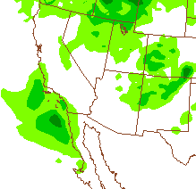
The early WRF-NAM composite radar echo forecast, from Atmo, for 4 pm this afternoon indicates widespread but light radar echoes. The WRF-NAM forecast of precipitation through midnight tonight (below) indicates that most of the echoes in the model forecast remain aloft, with rainfall reaching the surface most likely to our southeast. A stronger system may impact our area on the weekend, so something to keep an eye on.


Saturday, February 22, 2014

Today Is National Margarita Day

Who knows why such a day was declared - maybe Jimmy's behind it?


He's not a bad writer either and I recommend his book of short stories.


Fair Weather For February Events

February brings a number of annual events to Tucson, and this year, for the first time in several years, fair and warm weather has held sway for all of them.


Skies have alternated between perfectly clear and bright and periods with high clouds and somewhat dirty air. No threat of rain or snow this year. Above is shot from campus on one of the absolutely clear afternoons.

Out at the PGA Acupuncture Match Play tournament, an errant shot sent the gallery scattering and one poor soul had an encounter with a jumping cholla.


The annual Gem and Mineral show also brings some old fossils to town. The La Fiesta de los Vaqueros (aka Tucson Rodeo) begins its week with a parade. Below (bottom) shows the contrast from last year when snow was falling even here at the house on February 20th.


Friday, February 21, 2014

Yesterday's Storm Reports


Yesterday's severe thunderstorm reports (above) plotted on the 1630 UTC convective outlook from SPC. This morning (Friday, February 21st) the surface low is very intense (~970 mb) and centered over Lake Superior. The cold front is moving across the Appalachians toward the East Coast.

Thursday, February 20, 2014

Moderate Risk Of Severe Thunderstorms Late Today


For the first time in what I think is many weeks the SPC has issued an outlook for a moderate risk of severe thunderstorms occurring late this afternoon and evening (20 February) - see above.


As a strong 500 mb short wave (above is this morning's NAM forecast valid at 8 pm MST this evening) approaches the Great Lakes and Mississippi River Basin, strong winds at 850 (same forecast from NAM below) have transported GoM low-level moisture far north into the region where arctic weather has prevailed recently. In fact, at sunrise today the most unstable air was actually aloft over cold surface air and melting snow cover. Seems a sure sign that there will eventually be a Spring this year for those who have been besieged most of the Winter.


Contrasting Images On MAP List


These two images of airliners were posted on the MAP list this week by Kerry Emanuel and Cliff Mass.

They illustrate quite different attitudes and approaches. The Norwegian airplane above carries the image of Vilhelm Bjerknes, famous physicist and meteorologist from that country -

http://en.wikipedia.org/wiki/Vilhelm_Bjerknes 

The US airplane below carries the image of Mickey and friends.


Wednesday, February 19, 2014

Red Flag Warning This Afternoon


When I went to the NWS webpage this morning I saw that a large part of southeast Arizona is under a Red Flag Warning (above) because of conditions favorable for rapid spread of wildfires. The grid point forecast for the airport (TUS) also highlights "Red Flag Warning", as does the metro zone forecast below. However, when I read the actual text of the warning, I found that we are not under this warning here in the metro area, regardless of what all the graphics indicate. The Red Flag Warning is actually for areas east of a Safford - Douglas line, which is a small part of the area shown in red above, and not even close to the metro zone shown below. More than a bit confusing if a user just takes a quick look at the graphic products.

Regardless, it is quite early in the season for the wildfire threat to be starting - it's mostly due to the very wet summer monsoon period last year supporting enhanced growth of grasses. This has been followed by very warm and dry conditions, especially since December 1st.


Note that if a savvy user knows to dig deeper (under "Detailed Hazards" tab) within the NWS webpage, there is a graphic in there that shows the actual area affected by the Red Flag Warning, as per below.


Tuesday, February 18, 2014

Photos From Batavia, Illinois


Photographs from my sister Jan in Batavia, Illinois (right across the highway from the Fermilab). Above is looking out to patio by pool during yesterday's storm. Below is view from front porch this morning (Tuesday, February 18th) - Brrrrr.


More On Record High Temperatures

From the Tucson NWS webpage this morning:

Recap of Mid-February record to near record high temperatures
Strong high pressure that has been over the area since late last week brought near
record to record mid-February temperatures to the region through President's Day.
Near record to record highs can be expected again on Tuesday. Below is a recap for
select locations across southeast Arizona.
Tucson
Number of records set or tied - 3
February 15 - 88°; new record high; old record 85° in 1957
February 16 - 85°; tying daily record previously set in 1994
February 17 - 86°; new record high; old record 83° in 2004
The 88° from the 15th ranks as the 9th warmest February high on record, tied with three other dates.
The airport has recorded 5 straight days with highs of 80° or warmer, which ranks as the 4th longest
February streak on record. The record is seven straight days, which first occurred in 1989 and
then later tied 1995.
Tuesday forecast - 84°; February 18th record high is 85° from 2004.
If the record high is tied or broken on Tuesday, this would be the longest stretch of consecutive days
with daily record highs being broken or tied since there were 7 straight days in November 1999.
 ----------------------------------------------------------
There is currently a fire weather watch in effect for southeastern Arizona tomorrow (Wednesday, February
19th due to the high temperatures, low RH, and forecast gusty west winds.

In the longer term, the global models continue to amplify a ridge at 500 mb along the west coast.
                                     

The GFS ensemble mean and spaghetti plot for 500 mb above is valid at 5 pm MST on February 24th. The ridge 
is forecast to return with a vengeance; however, by 10 days out the models hint at a strong short wave breaking 
through the bottom of the ridge. Note that there is surprisingly little spread in the global forecast at seven days 
(right panel).

Sunday, February 16, 2014

Return Of The Dreaded West Coast Ridge?


Photo above is of the full moon setting over the northern Santa Rita Mountains - taken yesterday morning, Saturday, February 15th a bit before 7 am MST. It was very cold at sunrise but quite hot by midday near Sonoita. Here the house the lows on Friday and Saturday mornings were 36 F and 37 F with high temperatures each day of 86 F and 88 F - so very large diurnal swings of 50 and 51 F.


Have taken a look at the GFS ensemble forecasts for 500 mb for the coming week. Above average of the model's members is valid at 12 UTC this morning, Sunday, February 16. A low-amplitude, 500 mb ridge is centered over the U.S. and Canada. However, by 12 UTC next Sunday morning (the 23rd, below) the GFS and ECMWF models forecast a high-amplitude, bent-back ridge to rebuild along the West coast. The northern half of the western U.S. has benefited from the ridge's absence, with very heavy precipitation in many locations. But here in the Southwest we've had abnormal warmth and continued drought.


Friday, February 14, 2014

Thursday, February 13, 2014

Another Winter Storm In The East


Snow and ice is hitting much of the East today with wintry weather from Georgia to New England - web cam view above is from Harrisburg, Pennsylvania, this morning. Early morning surface plot below shows the extent of the current storm - I see many reports of moderate to heavy snowfall. More chaos in Washington D.C.


The GFS ensemble forecast averages for 500 mb indicate gradual changes for the coming week. Above is average forecast for 5 pm MST this afternoon, with a flat ridge affecting the Southwest. By next Wednesday afternoon, below, the Southwest ridge has been flattened away and there is a new, and stronger ridge over the Pacific north of Hawaii. It appears that the weather focus will remain to the north as per the winter so far.


Below is the operational GFS forecast of total precipitation through 5 pm next Wednesday, February 19th. The Northeast and Northwest are forecast to have heavy and very heavy amounts of precipitation. The dryness persists in this model forecast over all of the Southwest. So far there has been only 0.67 inches of rainfall here at the house since December 1st, 2013.


Wednesday, February 05, 2014

Bad Day To Be Travelling

Widespread winter storm is impacting travel this this morning from St.Louis - Chicago all the way to the northeast, where Boston currently reports heavy snow. I find conflicting information on line - Chicago O'Hare currently reports excessive delays while FAA reports no problems there - see below.


Most flights in and out of Boston's Logan Airport are currently cancelled, as per example for American Airlines below.


Monday, February 03, 2014

Moisture-Starved Short Wave To Move Across Arizona Today

First - a wrap-up on Saturday's showers. Here at house we ended up with 0.09" for the first day of February. Across the ALERT network 32 of 92 sites had measurable precipitation, with amounts generlly less than 2/10s of an inch. One station, CDO at Big Wash, reported 0.63", but I suspect that there are likely problems with that report.


The two PW graphics above (top from CIMSS at Univ. of Wisconsin for 10 UTC, and bottom from CIRA at Colorado State for 12 UTC) show that the short wave across southern California currently has little precipitable water with it. Color bar is shown for the top and for the bottom product: brown indicates less than 1/4 inch and the shades of greenish-blue are from 1/2 to 1 inch of PW.

The midnight NAM forecast (below) indicated no precipitation for southern Arizona through midnight tonight. However, the early run of the WRF-NAM indicated light precipitation amounts from eastern Pima County on across southeastern Arizona. So, likely some virga, mammatus, and sprinkles or light showers for parts of the metro area and eastward today.


Downton Abbey Trumps Superbowl


Who would have thought that this was how it would go and that many viewers would migrate to Downton Abbey as things progressed - but so it went. Ignore my post of yesterday.

Sunday, February 02, 2014

Superbowl Sunday And Groundhog Day All Together


East half of U.S. will celebrate Phil's forecast!
Edited to add: Well - blew that forecast. Surface map below is from time Phil supposedly saw his shadow. Sure looks very cloudy. Must have seen shadow due to all the stage lights and flash bulbs!


Go Broncos.


Saturday, February 01, 2014

Nice Surprise To Begin February


Above is a grainy view of clouds sitting on the Catalinas this morning - Saturday, February 1st.

Some light showers have fallen over northern parts of the Tucson area, especially around the Catalinas. The rain seems to have occurred after midnight, and January closes out here at the house with just a Trace for the month. But, February begins with 0.05" in the gauge at 6 am MST this morning. I see that 14 of the 92 ALERT stations had measurable rainfall during the 6-hours ending at 6 am. Amounts were light with only one site reporting 0.20". The morning dampness is very welcome.