Due to the interest generated by the blog thus far, we've decided to try opening up it up so that anyone can post a comment without having to be issued an individual inviation. So post away and we'll see how this works!!
We are also establishing a complementary webpage - this will allow postings of a more technical nature, including draft scientific papers. Some of these will hopefully be submitted to the Electronic Journal of Severe Storm Meteorology. Don't know about this publication media? Click on the ejssm link available on the blog links list for details. Regardless, we will announce the new webpage as soon as it is functional and has some content.
Wednesday, June 28, 2006
Another week and a half of storms amplifies the confusion
The monsoonal flow pattern setup again during the second half of June, and the associated thunderstorms and rain have created much confusion about whether the monsoon is causing these early summer rains in Arizona. The current state of weather affairs in southeast Arizona is illustrated below by two brief articles that have appeared in the "Tucson Citizen" newspaper:
Monday - June 26, 2006
Clouds and more Clouds
Moisture building now may bring early monsoon
Did you like the weather Sunday night? Mother Nature is expected to provide an encore every night this week, complete with high winds and possible rain.
Meteorologists believe the monsoon may even start this week.
'We're getting close,' said -----, a National Weather Service meteorologist in Tucson. 'Moisture is going to be increasing over the next couple of days.'
Up to 4,000 customers lost power during Sunday's storm, with electricity restored overnight.
Tuesday - June 27, 2006
Maybe soon
Signs say summer monsoon not yet upon us
It looks like it, it feels like it, but trust us - and if not us, the National Weather Service - the
monsoon has not yet begun.
For the monsoon to officially start the dew point must average 54 degrees on each of three
consecutive days, says -----, a meteorologist with the National Weather Service
here.
'We've hit 54 several times in the past few days, but we haven't averaged 54 yet on any given day,' -----said.
Sigh.
The average dew point Monday was 52 degrees.
We'll be watching.
Tuesday, June 27, 2006
Storms of Early June -- Monsoon or Not?
NOTE: The following comments were written 8 June 2006,
concerning the weather in Arizona during the first week of June.
--------------------------------
concerning the weather in Arizona during the first week of June.
--------------------------------
The tough question: "Are these storms the start of the Arizona monsoon or summer rainy season?" has already become an issue for the general public and the media in Arizona, and thereby also an issue for the NWS, and perhaps private forecast services. This question arises almost every year, but usually more toward the end of June or early part of July.
The weather: For the past week in Arizona (June 1- 7) there have been thunderstorms, lightning, rains, winds, some hail, some severe storms, and even two severe thunderstorm watches.
The synoptic pattern: Beginning a week ago, the pattern over the southwest US and northern Mexico became characterized by a strong anticyclone from 700 to 250 mb that has meandered around Arizona and the four-corners region. The high has now shifted eastward and is forecast by the models to relocate southward, toward a more typical position for mid-June. The flow pattern has been essentially a summer flow pattern with easterly to southerly winds aloft over southeastern Arizona. There has been enough moisture embedded with the flow, plus really serious moisture recycling from the rains, for there to be boundary layer CAPE somewhere in the state most every day for the past week.
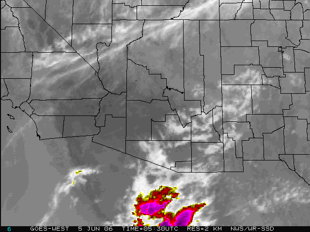
I've posted a June 6th satellite image (FIGURE 1) three upper-air charts (FIGURE 2 for June 4th, FIGURE 3 for June 2nd, and FIGURE 4 for June 7th ) along with a Tucson sounding for June 6th (FIGURE 5). Also posted is a map for June 6th showing lightning CG strikes to ground for the day (FIGURE 6).
What's a monsoon: The meteorological definition is that it is a distinct seasonal shift in the prevailing wind direction - usually the wind shift referred to is that of the surface wind. However, surface winds in this part of the world are typically dominated by diurnal flows generated by the complex orography, i.e., high elevation mountains in close proximity to low elevation desert. Thus, the average surface winds at Tucson are similar in July to those in January. So, we are forced to look aloft to find seasonal shifts from westerly winds to easterly winds. Note that clouds, rains, dewpoint temperatures, and other weather phenomena associated with a monsoon are not part of the meteorological definition of a monsoon.
Persistence: Arizona and parts of northern Mexico are far enough north that monsoonal flow regimes come and go during the summer as troughs in the middle and upper-level westerlies sometimes push across this region. These intrusions of the westerlies often produce "breaks" in the monsoon by bringing in drier, convectively stable, air from the eastern Pacific. However, the overland portion of the middle-level, subtropical high is usually located far enough north to result in average wind directions (300 to 600 mb) over much of Arizona during summer that are distinctly shifted from winter directions. The situation here in Arizona is thus one where periods of monsoonal flow develop intermittently from late spring through early fall, with the length of periods of monsoonal flow becoming longer during the second half of July and August. The occurrence of a summer monsoon is much better defined and persistent over portions of central and southern Mexico (the reason that Douglas et al. called it the Mexican monsoon).
Subtropical low-level moisture: During early periods of monsoon flow each year low-level moisture content (e.g., surface dewpoints) is not high. Often the only CAPE that develops during early monsoonal flow regimes is over the mountains, leading to high-based "dry" thunderstorms and the great wild fire dangers of late spring and early summer. By the middle of July, subtropical moisture, with much higher surface dewpoints and total precipitable water, has usually shifted northward, affecting much of central and southern Arizona. Swamp coolers become ineffective (they weren't doing such a great job here the last two days either!), storm bases lower, CAPE increases, and the heavily raining storms of summer occur.
The confusion: Much of the general public doesn't understand that the monsoon flow regime comes and goes. They want a yes/no answer regarding whether the monsoon has started or not. Unfortunately, there is no meteorological on/off switch at higher latitudes affected by the Mexican monsoon. Monsoon flow regimes are intermittent, the storms and high humidity are not a continuous daily phenomena. This has apparently led the public, and sometimes the media, to often refer to individual intense thunderstorms as "monsoons." As per, "Boy, that was some monsoon that hit us yesterday!"
The NWS yes/no definition: Since the public wants a yes/no answer, the NWS has developed a simple definition of the start of the monsoon. Here in Tucson there must be three consecutive days with daily average dewpoints of 54F or higher. The start of the monsoon is then declared to have occurred on the first of these three days. So, there is always a three day period of uncertainty before the NWS says, "Yes, the monsoon has "officially" started." (Note that Phoenix uses the same definition but with the threshold dewpoint being 55F.) The NWS at Phoenix and Tucson declares the start of the monsoon to have occurred based on observations at two points, leaving those interested in the weather in other parts of Arizona wondering whether the monsoon has "officially" started at their home yet.
Since there will usually be thunderstorms and rain within monsoonal flow patterns before the "official" onset of the monsoon, it is no surprise that confusion is unavoidable.
Monsoon or not: Finally, after all this long-winded background, my answer to this question. The storms of the last week have been, in my opinion, "monsoon storms" since they occurred in an unusually early, summer, monsoonal flow pattern. We'll experience a return to more normal westerly flow, and hot dry weather, before the monsoonal flow returns again. But, we've had a refreshing and interesting early start of our summer rainy season.
Monday, June 05, 2006
An early monsoon?
There's been a lot of talk and media articles about the SE Arizona storms of early June and whether or not they might signal the start of an unusually early monsoon. Let's look at this from a synoptic viewpoint . . . but first let's talk about what exactly is the monsoon in Arizona. My next post will address the storms of early June.
Sunday, June 04, 2006
The MadWeather Blog has begun!
I am establishing a weather blog so that I can comment on issues of weather interest here in the Southwest, and sometimes other places. Stay tuned for future postings. One of the benefits of being retired is that I can be a "free range" commentator on a variety of things that I think I know at least a smidgen about. During the coming summer I hope to address things like:
- The mystery of why there are about half as many thunderstorms observed in Tucson now as there were 5 to 10 years ago
- Conditions that lead to organized MCSs in Arizona
- The value, or lack thereof, of weather forecasts that call for climatological conditions and POPs each of the next 5 to 7 days
- The usefulness of seven-day forecasts in general
- Gulf of California moisture surges
- Whatever else might catch my attention.
This will be an "invited participant" blog, once we figure out how to get this component functional. When we do, all who have been alerted of the blog will be invited to contribute their opinions, comments, etc., when so moved.
Please feel free to "advertise" this blog to others who might be interested.
Subscribe to:
Posts (Atom)