Tuesday, November 30, 2021

Last Day Of Fall


Colorful cloud structures over the Catalinas this morning at about 7:00 am MST. 

The last three months have been mostly warm and dry here at the house. Total rainfall was 1.53" - but month by month it was: September 1.49"; October Trace; and November 0.04". So we have had two continuous months with virtually no meaningful rainfall.

The GFS forecasts for the next couple of weeks are shown here (above is precipitation through 18 UTC on December 7th and below is precipitation through 06 UTC on December 15th). So that model is indicating some hope for rain here after the first week of Winter.


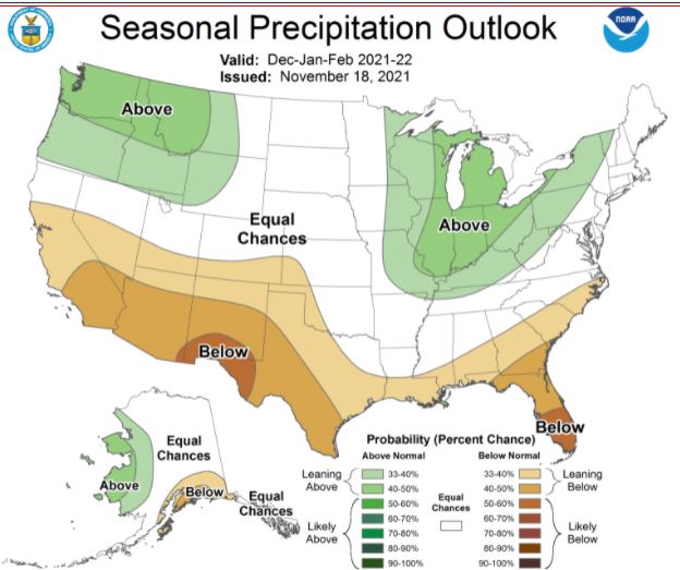
The seasonal outlooks (from the NWS Climate Prediction Center) for Winter - above and below - indicate that Winter here in the Southwest will continue much as did Fall - dry and warm. So it goes.

Wednesday, November 24, 2021

Bit Of Rain - Finally

Some sunshine peeking through a bit before 8:00 am MST this morning - from campus above and down in Bisbee at bottom.

Light showers moved across parts of the metro area after midnight last night: 24-hour amounts from the ALERT network (above) and from Univ. of Utah's MesoWest (below). Remember that Alert only records amounts of 0.4" and greater (which occurred only over the mountains). MesoWest indicates lighter amounts scattered across the metro area. Here at house we finally had measurable rain (first since September 30th), but amount was just 0.02", which was enough to dampen the patio and open ground. But, a very nice smell of moisture in the air early this morning.


Morning sounding at TWC/TUS (above from NCAR RAP) indicates low-level moisture up to just above 600 mb, and there appears to be a slight amount of CAPE present. The 500 mb analysis (below, also from RAP) shows two weak, short-wave troughs. One is over eastern Arizona, with a trailing trough across Nevada and central Californina. 

The trailing feature may bring another chance for light showers late today and tonight. The 12 UTC forecast from the WRF-RR (second below) forecasts only some widely scattered, very light showers over eastern Pima County through 5:00 am on Friday the 26th. Pleasant temperatures for Thanksgiving, but WRF forecasts also indicate some gusty east winds during the day.


Sunday, November 21, 2021

Heading Toward December

Gray skies this morning but with some patches fo blue showing. Down at bottom is view of some nice sunrise colors at Guaymas, Mexico.
The 06 UTC GEFS plumes for QPF (above) continue to show very slight chance for sprinkles on Wednesday. Plumes for temperature (below) indicate slight cooling for Wednesday and Thanksgiving day. The 06 UTC GFS forecast for precipitation through the 5th of December (second below) shows little in store for most of the Southwest.


Friday, November 19, 2021

Looking Ahead To Thanksgiving


View of sunrise this morning - above, looking east from San Simon. At bottom is a post-midnight view of last night's partial eclipse (photo by A. James McCarthy).

Above shows GEFS plumes for temperature at the airport for next eight days. Warm temperatures continue, but with slight cooling for Thanksgiving and end of week. The plumes for QPF (below) indicate chances for light showers on Wednesday night into Thanksgiving morning.


The 06 UTC GFS forecast for 500 mb (above) shows a fairly strong, closed low south of Tucson at 11:00 am MST on Thanksgiving day. Forecast for 24 rainfall from same run (below) indicates some chance for measurable rain for 24 hours ending at 11:00 pm Thanksgiving night. If this forecast verifies, it will be the measurable rain here since September 30th!


Wednesday, November 10, 2021

The Edmund Fitzgerald


Photo of the Edmund Fitzgerald, which was one of the largest iron ore transport ships ever built. The Fitzgerald sank in Lake Superior sometime after 7:00 pm CST on November 10th, 1975, as a intense surface low moved across and to the north of the lake. The 29 crew members on board all perished.

The probable tracks (above - from the NTSB investigation of the sinking) of the Fitzgerald and a following ship - the A. M. Anderson - on the 9th and 10th of November 1975. The approximate location of the surface low (below) about the time that the Fitzgerald broke apart in high winds and seas. Second below is a colorized IR image (from the Univ. of Wisconsin and NOAA) at about 2 hours before the disaster. There is more information about this legendary (as per Gordan Lightfoot's song - https://www.youtube.com/watch?v=9vST6hVRj2A ) disaster at:   https://www.weather.gov/mqt/

Monday, November 08, 2021

Just Some Photos


Sunrise this morning along I-10: above at San Simon and below at Wilcox.


Denver just after sunset last evening - above.

Mauna Lea above before sunrise. Old Faithful spouting this morning with very few viewers.


Monday, November 01, 2021

October Summary


 Midday view of campus and west end of the Catalinas.

October provided a full month of mostly Chamber of Commerce weather - mild, sunny, and dry.

There was a Trace of rain on the 12th and 26th, and a cold morning low here of 36 F on the morning of the 13th. Nothing else noted in my logbook. Rainfall across the ALERT network is shown below - keep in mind that ALERT does not record daily amounts that are less than 0.04 inches. Thus, the October totals from the network are biased on the low side.