Sunday, March 31, 2024

Morning Showers


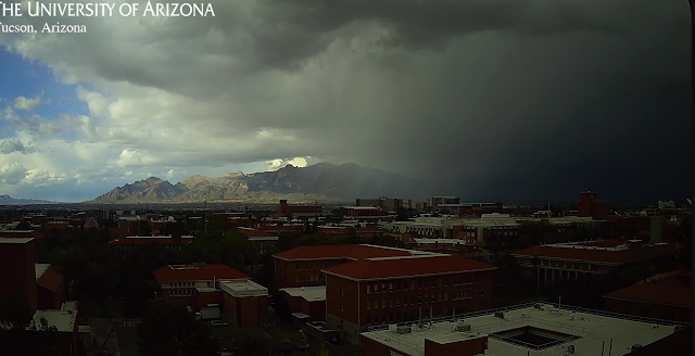
Showers on the Catalinas already this Easter morning(view above from 7:50 am MST). Light sprinkles here at house.

The 12 UTC GEFS plumes for QPF at the airport (above) don't get things really started here until around noon.

The 12 UTC runs of the WRF-RR at Atmo show a similar scenario - above is total precipitation through noon and below shows total precipitation through midnight tonight.

Friday, March 29, 2024

Showers Likely On Easter


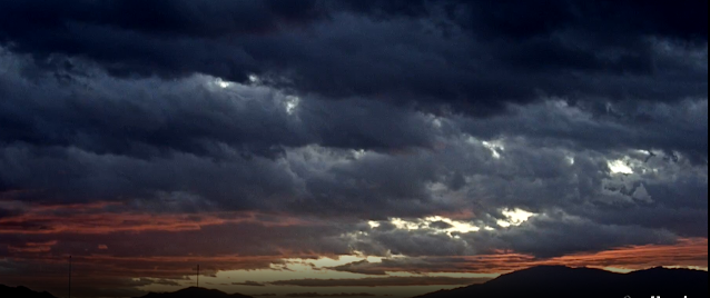
Some pre-sunrise color at about 6:05 am MST this morning - looking toward the Rincons.

The 500 mb forecast from 06 UTC GFS run showing strong trough from eastern Idaho south to central Baja. Precipitation forecast (from 06 UTC WRF-GFS - below) indicates significant precipitation event for most of Arizona through 5:00 am on Tuesday, April 2nd. The GEFS plumes from 06 UTC (second below) indicate averages for airport around 0.75".


Morning graphic from NWS TUS Forecast Office (below) summarizes situation through April 1st. The NWS forecast POPs are 70 to 80 percent at the airport from Sunday, through Sunday night and Monday.

Wednesday, March 27, 2024

Showers Last Evening


Storm in foothills at 4:50 pm MST yesterday afternoon. This one skipped by to our east, but there were heavy showers later, around 7:00 to 7:30 pm at the house. View at bottom is looking toward Redington Pass at 5:25 am this morning.


There were only isolated CG flashes in eastern Pima County yesterday. Above plot shows flashes detected through 0833 UTC this early morning (from Atmo and Vaisala). Graphic below shows 24-hour rainfall amounts ending at 15 UTC this morning (from Univ. of Utah). Here at house we had 0.12".


GEFS plumes from 06 UTC runs (above) are for precipitation at the airport. Plumes indicate an active, showery period on the 31st of March and 1st of April. The 500 mb forecast (below, from the 06 UTC run of the GFS) indicates a deep, positively-tilted trough over the Southwest at 00 UTC on April second - next Tuesday.


Monday, March 25, 2024

Showers Here Again


View toward the Rincons at 6:15 am MST shows a bit of color.

Light rains fell over much of the lower elevation Alert sites during the past 24-hours ending at 7:30 am this morning (above and below). Here at the house there were showers late in the afternoon and a couple of times during the night. Gauge showed 0.11" this morning.


Plot of detected CG flashes (above for 24-hours ending at 0803 UTC this morning) shows that most thunderstorm activity avoided the metro area.

The 06 UTC QPF plumes (below) suggest that a more significant event may develop for the first day or two of April.


Finally, there was a strange disconnect regarding the forecast on the NWS TUS website. Above graphic (issued 4:08 am) indicates fairly high POPs for today. However, the point forecast for the airport (below - issued at 5:47 am) indicates only slight chances for showers today.

Sunday, March 24, 2024

Update Midday Sunday


Snowy morning up in Summerhaven - view above is from 9:50 am MST.

ALERT plots (above and below) show rain amounts across the network for 24-hour period ending at 6:00 am this morning. Note that rain event occurred mostly from 3 to 5 am, early this morning. Here the house we had 0.25", as did Atmo; the airport reported 0.30" and DM had 0.36". Plot of detected CG flashes (second below - from Atmo and Vaisala) is for 24-hours ending at 1703 UTC this morning. There were thunderstorms in Pima County but they mostly avoided the metro area. Note that the airport did record a wind gust to 45 mph at 3:53 am.


Plot of 250 mb observations (above) shows that there is a very strong jet across northern Mexico and also that the trough axis is still to the west of Arizona. The current NWS morning forecast for the airport (below) continues with 60 POPs for tonight, as the trough axis passes by.

Friday, March 22, 2024

Showers Beginning Sunday


View to the east at 6:20 am MST this morning.


Forecast for 500 mb valid at 06 UTC on 25 March from the 06 UTC GFS run last night. Strong short-wave is across Arizona to west of San Diego.
QPF plumes for the airport from the 06 UTC GEFS runs, with several periods of rain indicated from early Sunday through through Tuesday. There a large range in the amounts of almost an inch.
Plumes for temperature (above) indicate strong cooling starting Saturday night, but with recovery to warm temperatures by end of the week. Plumes for wind (below) indicate several periods of strong winds during the week, beginning tomorrow afternoon.


The 00 UTC WRF-GFS run (above) indicates widespread precipitation across much of the state through 5:00 pm on Tuesday the 26th. Current morning forecast from the NWS for the airport (below) calls for high POPs on Sunday night. Winds gusting in the 30 to 40 mph range are, to me, a bit more than "breezy"!

Wednesday, March 20, 2024

Showers Possible On Weekend


View looking toward Rincons/Redington Pass at 6:15 am MST this morning.

GEFS plumes from 06 UTC for QPF. Showers indicated as likely Sunday into first part of next week.

 Plumes for wind (above) and temperature (below) indicate windy on the weekend. Plumes for temperature calling for much cooler on Sunday and Monday. At bottom is 00 UTC graphic for precipitation through 5:00 am on March 25th.

Saturday, March 16, 2024

Quick Summary


View of Table Mountain and Finger Rock at 7:40 am MST this morning.


Plot of detected CG flashes yesterday (above - from Atmo and Vaisala) for 24-hours ending at 0803 UTC today. There were just a few flashes in Pima County, but TUS and DM both noted thunder around 6:00 pm.


Precipitation reports from the ALERT network (above and below for 24-hours ending at 7:30 am this morning. Amounts were generally light, with a bit of a donut hole over metro Tucson. Here at the house there were off-and-on showers that left only 0.03" in the gauge; TUS had 0.01" while Atmo and DM both reported 0.04".


The GEFS plumes for QPF from the 06 UTC GEFS indicate chances for another very light event tomorrow and again around Tuesday. Note that the plumes yesterday over-did the event - see previous post. The temperature plumes (below) indicate gradual warming through the coming week.

Friday, March 15, 2024

Showers West Of Metro Area


View of pre-sunrise colors looking toward the Rincons at 6:35 am MST this morning. View at bottom is looking toward the Catalinas at 6:40 am.

At 500 mb this morning (above) the closed low is centered somewhere near Yuma. The low is forecast to linger over Arizona into early next week. The GFS forecast below is valid at 00 UTC on St. Patrick's Day.

This morning there are showers west of interstates, that are moving rapidly northward. The precipitation forecast from the 12 UTC WRF-RR (below) is valid for the period ending at midnight tonight. Widespread rain/snow covers all of Pima County. The morning NWS forecast for the airport is giving a 60 percent chance of measurable rainfall today.