Thursday, November 30, 2023

Waiting For Showers


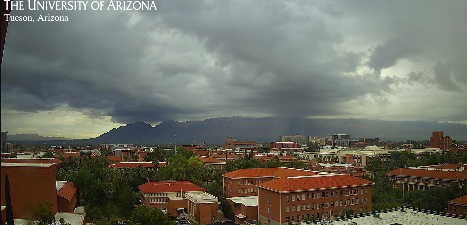
Clouds hanging on the Catalinas at 8:00 am MST this morning.

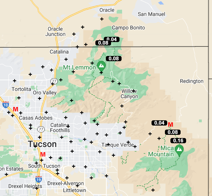
There has been a bit of light precipitation on the north sides of the Catalinas and Rincons during 24 hours ending at 8:00 am this morning (as per plot above - note that there was also 0.04 down at Elephant Head Butte on the northwest side of the Santa Ritas). Summerhaven webcams show that there was a skiff of snow up there overnight.

The TWC/TUS sounding this morning (above) has essentially no CAPE but is moist in middle levels, with strong, westerly winds above 500 mb. The 500 mb forecast (below from the 06 UTC GFS run and valid at 5:00 pm today) shows last night's shortwave to the east, but with another entering Arizona to the west.


The 12 UTC run of the WRF-RR (above) indicates continued dry conditions for southeastern Arizona, but earlier runs had considerable precipitation across our area - one needs to peruse the various runs to get a better feel for the WRF forecasts for this event. The current NWS forecast (below) calls for high POPs at the airport tonight and tomorrow - NWS also has out alerts for heavy snows at higher elevations - see the NWS webpage for TUS.

Wednesday, November 29, 2023

Chance Of Showers As December Begins


View of clear skies over the Catalinas at 7:30 am MST this morning.

Complicated situation this morning. The morning sounding for TWC/TUS (above) is dry and stable, with moderate westerly winds aloft. At 500 mb several, weak short waves will be crossing Arizona during next couple of days. The GFS forecast below shows 500 mb analysis valid at 06 UTC on December 1st.

The 06 UTC GEFS plumes for QPF at the airport (above) indicate several periods with chances for showers, with best chances centered on Friday. Current NWS graphic (below) calls for showers tonight. The morning forecast for the airport (second below) has 40 percent POPs for tonight and then again Thursday night and Friday.


The 12 UTC WRF-RR forecast from Atmo (above) shows dry conditions for all of southwestern Arizona through noon tomorrow - quite different than NWS forecast (second above). The 09 UTC WRF-HRRR forecast for precipitation through 2:00 am on Saturday the second of December (below) indicates light amounts across portions of eastern Pima County. Will be interesting to watch how all this evolves, as we head toward first weekend of December.

Sunday, November 26, 2023

Chilly Morning


Mostly clear this morning, but with a bit of cloud over Catalinas, perhaps an old contrail off to north of the mountains.


Yesterday morning's rain amounts across northern portion of the ALERT network (as reported in previous post - 0.20" here). Graphic below (from MesoWest) shows morning low temperatures across the metro area, with some readings into the 30s F here and there. Low at house was 35 F - making this the coldest morning for the Fall so far.

Saturday, November 25, 2023

Light Showers Across Metro - Updated

Skies have cleared at noon here and the morning showers have totaled 0.20".

Catalinas obscured by rain at 7:45 am MST this morning. View at bottom shows Summerhaven at 7:25 am, with light snow occurring.

ALERT data (above for 24 hours ending at 8:30 am) shows rain amounts of 0.04", and more, have occurred only over the northern part of the network. Here at the house there was 0.08" in the gauge at 8:30 am, but light rain was still falling.

The 500 mb analysis this morning (above) shows that yesterday's closed low has opened up and moved eastward. There is a primary shortwave from eastern Montana southward across central Arizona, with a trailing shortwave from northern Utah westward across central California. Features are expected to continue moving eastward during day today.

The morning sounding (above) from TWC/TUS shows moisture below about 650 mb, with dry air above. Winds continue strong and from the west. The GEFS 06 UTC plumes for QPF (below) end rain at the airport around noon today, but also show possiblity of a more signifcant event at the end of the month, continuing into first couple of days of December.


Friday, November 24, 2023

Unsettled Weekend


Colorful skies (purple to yellow/green) over the Rincons at 6:40 am MST this morning, as the long Thanksgiving weekend continues.

At 500 mb (above) there is a large, closed low over the Great Basin. This feature will move east-southeastward during coming two days and weaken markedly. The morning sounding from TWC/TUS (below) is very dry and stable, with strong winds aloft.


The 06 UTC GEFS plumes for QPF at the airport (above) indicate very slight chance for light showers at the airport tomorrow.

The current NWS forecast (above) indicates 30 percent POPS at the airport late today into Saturday morning. However, the 06 UTC run of the WRF-GFS at Atmo (below) keeps southeastern Arizona very dry through next Monday night, which certainly fits with the morning sounding. Regardless, our very dry November continues.

Wednesday, November 22, 2023

Windy

View of the Catalinas and deep blue, clear skies is from 9:00 am MST this morning.


It was a windy day yesterday and current NWS forecast for today calls for gusts as high as 34 mph at the airport.

Yesterday wind gusts of 30 to 40 mph were common across southeast Arizona. Pioneer Air Field, near Ft. Huachuca, reported gusts to 43 mph and the RAWS at Mt. Hopkins hit 78 mph. Here at the house, I estimated gusts from the east in the 35 to 40 mph range.

Sunday, November 19, 2023

Event Summary

Hard to see, but this image from 3:00 pm MST yesterday captures a partial rainbow.


ALERT rainfall reports for 24-hours ending at 7:30 am this morning. There were a couple of heavy reports north part of Catalinas, but most amounts were quite light. For the entire event, which started before 7:30 am yesterday, we had 0.10"; as did the airport and DM; Atmo reported 0.15".


Looks like we now will have a dry spell that could extend through the end of the month. Forecast below (from the 06 UTC run of the GFS) shows rainfall through 12 UTC on Friday, December 1st.

Saturday, November 18, 2023

More Showers

Showers moving in from the west at 8:15 am MST this morning (view above and radar base scan below).


Precipitation for 24-hours ending at 7:30 am (above from ALERT network) was concentrated in a band from south of Three Points northeastward to the Catalinas. Here at house there was 0.06" in the gauge.


The upper-air sounding from TWC/TUS (above) this morning is very similar to yesterday morning's - PW over an inch, bit of CAPE, and strong winds aloft. Current NWS morning forecast below.

Friday, November 17, 2023

Light Showers Last Night


View of the Catalinas at 7:48 am MST this morning, with a bit of fractus at east end.

Plot of detected CG flashes for 24-hours ending at 0813 UTC (above from Atmo and Vaisala) shows that there were some thunderstorms in northern portion of eastern Pima County - didn't hear any thunder here.

Showers were fairly widespread across the ALERT network - plots above and below show 24-hour rain amounts ending at 7:30 am this morning. Amounts were generally light: here at house we had 0.08"; the airport reported 0.04"; DM had 0.02"; and Atmo recorded 0.05". Most of rain occurred after dark last night from around 8 to 11 pm.


Morning sounding from TWC/TUS (above) has over an inch of PW, even with very dry mid-levels. Winds aloft are westerly and remain quite strong above 500 mb. Sounding has perhaps a sliver of CAPE.


Forecast above is for total precipitation through midnight tomorrow night and is from the 12 UTC WRF-RR run at Atmo. The current NWS forecast this morning (below) calls for best chance of additional showers occurring tomorrow.

Thursday, November 16, 2023

Quick Update Thursday November 16th


View of the Catalinas from campus at 7:50 am MST this morning shows a gloomy start to the day.

IR image from 7:10 am (above) shows plume of clouds with colder cloud-top temperatures just nudging into southern Arizona. The morning sounding (below from TWC/TUS) indicates deep moisture, with almost an inch of PW, but essentially no CAPE. Most noticable aspect of the upper-air data are the strong winds, greater than 100 kts, above 400 mb.


Forecast of total precipitation (above - from the 12 UTC WRF-RR run) indicates widespread, but mostly light precipitation across most of southern Arizona through 6 am tomorrow.

Graphic above (from the NWS Forecast Office) shows POPS for measurable precipitation through 11 pm tonight - value for the airport is 38 percent. Current forecast for the airport (below) indicates highest POPS during the day on Saturday. Still waiting for first November rain here at the house.