Monday, July 31, 2023

More Nighttime Showers


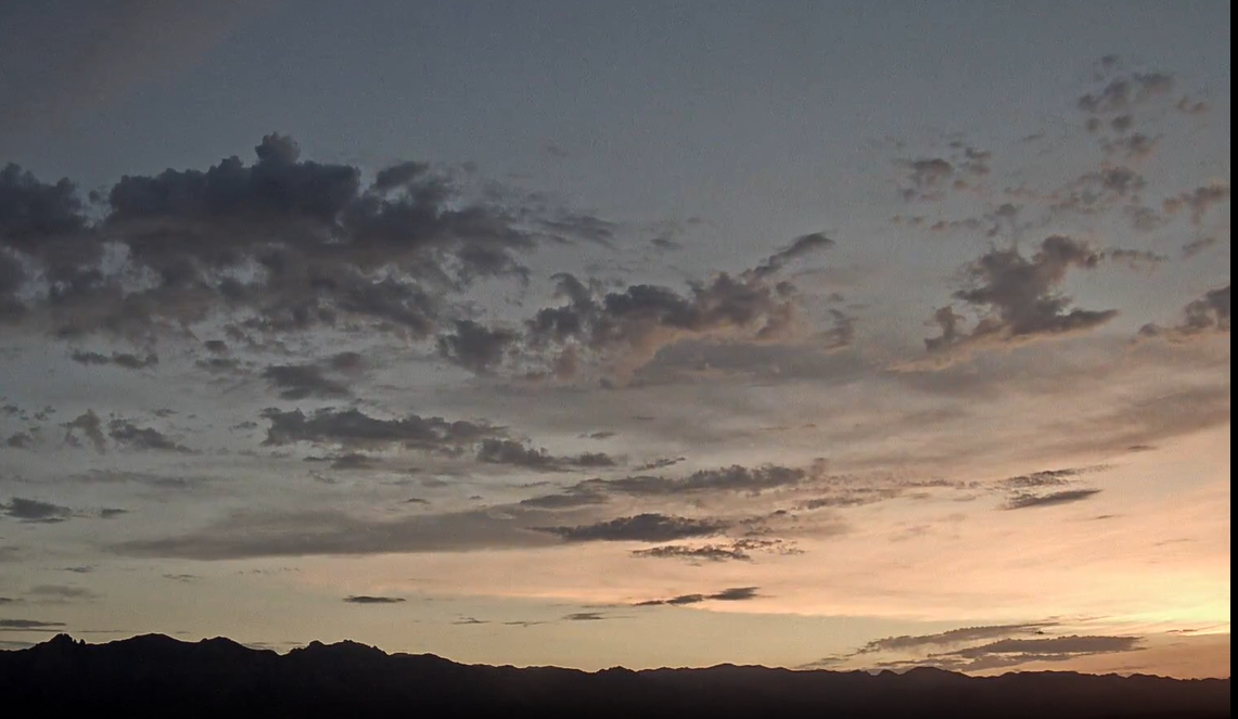
View looking toward the Catalinas at 4:50 am MST this morning.


Plot of detected CG flashes through 0713 UTC (around midnight) shows some storm activity in eastern Pima County, but with very active  and large area to the west. There may have been a bit of thunder here.

Plot of rain reports from MesoWest (Univ. of Utah - below) through 7:00 am this morning shows light showers west, foothills, and east toward the Rincons. Report of 4.67" near downtown is obviously from a bad gauge. Although TUS, DM and Atmo reported no rain, we had 0.05" around midnight.

Several large MCSs moved westward along the Borderlands. This one at 0915 UTC IR image below) is moving into southern California, where there four reports of severe winds.


The 500 mb inverted trough that was supposed to move by today appears to have weakened dramatically and already passed by our area (above 12 UTC 500 mb chart from NCAR RAP).

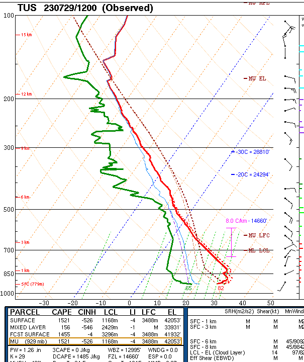
The morning sounding (below) from SPC has moistened considerably in lower levels (finally) and has considerable CAPE with southeast steering winds. However, there is a capping layer around 700 mb that will have to be overcome.


Several of the recent WRF runs have really zeroed in on the metro area - as per above 12 UTC WRF-RR forecast of rainfall through midnight. Below is the morning storm graphic posted on the NWS website. The NWS POPs for measurable rain at the airport are 80% today and 60% tonight.

Sunday, July 30, 2023

Storms After Dark Yesterday

Vivid CG flash strikes Flat Top at about 1:00 am MST this early morning.

Detected CG flashes since 1003 UTC this morning, showing abundant thunderstorm activity over eastern Pima County during the night.

Plots of ALERT rainfall for 24 hours ending at 9:00 am this morning. Rain reports mostly in southern two thirds of the network, with area coverage around 50 percent.

Here at house we had had thunder and 0.13" after dark; the airport had 0.18" DM reported thunder with gusts to 51 mph and 0.32"; and Atmo had about 0.32".


Forecast above is for rainfall through 6:00 am tomorrow morning - from the 12 UTC WRF-HRRR. Current am graphic from the NWS below - note POPs at airport currently 30 today, 50 tonight, 80 tomorrow and 60 tomorrow night. Quite a difference again in the forecasts for today and tonight.

Saturday, July 29, 2023

Severe Storms Yesterday


Large thunderstorm over the eastern Catalinas at 5:15 pm MST yesterday afternoon.

Heavy thunderstorms moved across much of the metro area during the evening yesterday - detected CG flashes (above, from Atmo and Vaisala) for 24 hours ending at 0733 UTC early this morning. Here at the house we had thunder, gusts estimated 50 to 60 mph and 0.16" of rain. Power went out about 6:30 pm and didn't come back until after 5:00 am this morning. 

The airport reported thunder, gusts 64 mph and a Trace; DM had thunder with gusts to 58 mph with rainfall details missing; and Atmo reported gusts to 57 mph and 0.31" of rain.

ALERT reports through 7:00 am this morning (above and below) show widespread rain over the northeastern portion of the network. Some amounts ranged from a half to over an inch.


The morning 500 mb analysis (above from NCAR RAP) shows the anticyclone centered over southern Colorado this morning. Moist, easterly to southeasterly flow prevails from southern New Mexico across much of Arizona. An inverted trough is over northeastern Mexico and southeast Texas. This feature, and the upper-level low with it, are moving our direction and will play a significant role in southern Arizona weather next couple of days.

The morning sounding (below from SPC) again does not look particularly favorable for storms today. Winds are generally eaterly at 20 kt or less, and deep-layer CAPE is quite small. I have been fooled by poor morning soundings several days recently. However, I would not anticipate widespread storms with this sounding, especially given that drier air is lurking just off to the east. 


However, the NWS morning forecast indicates very high POPs for today (above), and the 06 UTC WRF-GFS forecasts widespread rains across much of Pima County (below). Time will tell.

Friday, July 28, 2023

Winds But No Rain


Morning view of Catainas at about 5:30 am MST today.

There was considerably reduced CG activity over eastern Pima County yestery (plot of dtected CG flashes above through 0803Z this morning). There was enough lighting nearby to knock out our power for over an hour just after dark. Atmo reported a gust to 40 mph. Note the cluster of flashes out west in La Paz County - this storm over-turned, or jacknifed, about 10 semis on I-10.

Only thirteen reports of rainfall across entire ALERT network during 24 hours ending at 6:30 am. Yesterday's WRF forecast verified quite well - see previous post.


The 12 UTC upper-air sounding for TWC/TUS (above) is still very dry with very deep boundary layer. Considerable low-level cooling, plus just a sliver of CAPE, are again not very favorable for low-elevation storms.

The 12 UTC WRF-RR run (above) forecasts almost nothing for eastern Pima County through 6:00 am tomorrow morning. The morning NWS forecast below continues more agressive than the WRF forecasts. An inverted trough in the easterlies will swing by this weekend, hopefully pushing more low-level moisture into southeast Arizona.

Thursday, July 27, 2023

Another Stormy Evening


View of storms over eastern Catalinas at 7:20 pm MST last evening.


Eastern Pima and Pinal Counties were the focus of thunderstorm activity yesterday - as per plot of detected CG flashes through 0703 UTC (from Atmo and Vaisala).


Rainfall was widespread across much of the ALERT network (plots for rainfall reports through 06:30 pm). We were in the donut hole over northwest metro area. Considerable thunder here but only light sprinkles. There were quite a few reports greater than a half an inch, and two reports of more than an inch.

There were also six reports of severe wind gusts northwest of Tucson last evening - as per SPC Reports map, second below.


This morning's TWC/TUS sounding (above from Univ. of Wyoming coninues with limited PW, perhaps a sliver of CAPE. The deep, old BL sits above a very cool surface layer produced by yesterday's storms. Hard to see this sounding supporting thunderstorms.


The 12 UTC WRF-RR (above) has only isolated storm activity through noon tomorrow, while the NWS is forecasting storms later today - above and below.

Wednesday, July 26, 2023

Showers Here

View of Orion over the Rincons at about 4:40 am MST this early morning.

Plot of detected CG flashes for 24 hours ending at 0923 UTC this morning (above from Atmo and Vaisala) shows only isolated thunderstorm activity over eastern Pima County. Plot of 24 hour precipitation (below from MesoWest) shows rain at only a few locations across the metro area. 

Here at the house we had thunder, wind gusts to around 40 mph and 0.05" a bit before 7:30 pm. The airport had thunder, gusts to 32 mph and 0.11", DM had thunder but no rain, and Atmo reported 0.09", making yesterday a fairly minor event.


The 500 mb anticyclone is elongated east-to-west this morning (above from SPC), with the center over the northeastern corner of New Mexico.  

Plumes from the 06 UTC run of the GEFS models (above) indicate increasing activity over the weekend. The NWS morning forecast has POPs of 70 percent each forecast period from Sunday through Monday night - these are agressive POPs for so far out during summer.

Forecast below is from 00 UTC WRF-GFS and is for precipitation totals through noon on Tuesday August 1st. Model forecasts a wet end for what's so far been a pretty dry month.

Tuesday, July 25, 2023

Isolated Storms


Large thunderstorm over the Catalinas at 6:00 pm MST yesterday afternoon.

Plot of detected CG flashes (above, from Atmo and Vaisala) for 24 hours ending at 0730z this morning. There were some flashes over the metro but most activity was over and west of the Catalinas. Plot below shows ALERT rainfall data through 8:00 am this morning - isolated storms at low elevations but many reports over and near the Catalinas. We had plenty of rumbling thunder here, but no rain.


Here are three rainfall outlooks for today: above from NWS showing their POPs; below from 12 UTC WRF-RR through noon tomorrow; and bottom from 06 UTC GEFS showing plumes for coming seven days.

The NWS is quite optimistic compared to the model forecasts.


Monday, July 24, 2023

Scattered Storms


Nice view looking toward the Rincons at 5:30 am MST this morning.

Considerable thunderstorm activity over most of eastern Pima and Santa Cruz Coutnies yesterday afternoon and evening - as per plot of detected CG flashes for 24 hours ending at 0803Z this early morning. There was rumbling thunder here for a long period in the evening.

Rain was scattered through much of the ALERT netwrok - plots here for 24 hours ending at 7:00 am this morning. Note that several sites had more than half an inch.

Here at house: first - I neglected to check the gauge yesterday and when I did I found that there had been 0.02" during the night Saturday. Light sprinkle showers around dark yesterday left only 0.01" in the gauge this morning.


The 500 mb analysis this morning (above from SPC) shows an impressive anticyclone centered over southwestern Colorado. However, warmer and drier air is upstream and threatens to impact our area.

The morning sounding (below) has considerable CAPE, but still has large T/Td spreads below 700 mb. Given my problems with the soundings last few days, I'm not sure what to make of today's situation. Several pluses and minuses are at play. The WRF runs this morning tend to keep storms to our south and west later today. The NWS morning forecast keeps airport POPs at 30 to 40 percent through Wednesday. I am just going to have to be an observer this afternoon, while hoping for the best.