
Morning view looking toward Redington Pass at 5:45 am MST today.


Morning view looking toward Redington Pass at 5:45 am MST today.

Pre-dawn view looking toward Redington Pass at about 5:40 am MST this morning


The 06 UTC run of the GFS (below) for total precipitation (below) indicates dry conditions for all of the Southwest through 06 UTC on November 12th. Basically we are looking at beautiful Fall weather for next couple of weeks.


Clean, crisp skies this morning at 7:20 am MST, with only a few scattered clouds over the Catalinas.

Plot of detected CG flashes (from Atmo and Vaisala) for 24 hours ending at 1:03 am this early morning indicates widespread thunderstorm activity across eastern Pima County.

Data from the ALERT network (above and below for 24 hours ending at 7:00 am this morning) show widespread rain reports, except fr the northwest corner of the network. Many amounts were over half an inch, with three sites exceeding an inch. Here at the house we had 0.69", most of which fell shortly after 1:00 pm. DM reported 0.58", the NWS reported 0.19" at the airport, and Atmo had only 0.05". It was most rain here at the house since mid-July (0.82" on July 17th).


In the eastern Pacific Hurricane Otis (shown in IR image above just after landfall near Acapulco) intensified rapidly as it approached Mexico. The storm went ashore around 0625 UTC as a Category 5 hurricane with sustained wind speeds around 165 mph. Graphic below relates some details regarding Otis' strength. There was probably very serious damage across the Acapulco area.


Cb over west end of Catalinas at 8:00 pm MST last evening. We had some thunder here a bit after 8 pm, but no rain.


Have been away this morning, but here's a quick update. View above is looking toward Redington Pass at 6:15 am MST this morning.

A significant, 500 mb short wave is digging into Arizona and northwestern Mexico. The forecast above (from the 12 UTC GFS) is valid at 18 UTC tomorrow and indicates strongest vorticity-advection occurs to our southeast,

The WRF-RR run from 12 UTC this morning forecasts a nice event for the metro area (below forecast valid for period ending at midnight tomorrow night). Fingers crossed.


View of Catalinas at 6:10 am MST this morning, again showing cloudless skies.


View toward the Rincons before sunrise this morning, showing nearly cloudless skies. Even though it is late October, temperatures remain summer-like over southeast Arizona. The high temperature at the airport yesterday reached 100 F, breaking the old record from 1921 of 99 F. High today could also hit record levels (record currently 97 F in 2003).

Most interesting weather is far to the south, as Hurricane Norma moves slowly northward toward southern Baja (IR image from 1520 UTC this morning shown above). Norma briefly reached Category 4 strength yesterday afternoon (sustained winds reached 115 kt). Current morning outlook for Norma's track (below from NHC) indicates storm brushing southern Baja and going ashore in central Mexico.


View toward the Rincons at 6:15 am MST this morning.

The morning upper-air sounding from TWC/TUS (above) shows a very deep, well-mixed, residual boundary layer (BL) that has a small amount of CAPE above 600 mb. The radar image from 9:15 am (below) shows a small area of storm echoes generally along I-19 toward Nogales - note that these data are from the 4rth tilt (3.1 degrees) because of the large area of terrain blockage that occurs southwest of the radar. Second below shows detected CG flashes (from Atmo and Vaisala) through 1613 UTC.


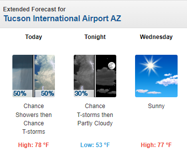
Forecast above is from the 12 UTC WRF-HRRR and shows rainfall through 6:pm this evening - all the rainfall in our area is over by this time in the WRF forecasts. Current POPs from the NWS (below) are valid through midnight tonight.


View of the Catalinas at 8:15 am MST today shows another morning with cloudless skies.

Analysis of TPW (above - from 15 UTC) shows very dry conditions across almost all of the continental US. While the 12 UTC morning sounding from TWC/TUS (below) shows low PW, no CAPE, and quite variable winds aloft.


Somehow the WRF model runs forecast an increase in PW during the day today, with light showers at, or near, the airport. Forecast above is from the 00 UTC WRF-GFS and is valid through 5>00 am on October 23rd. Very warm forecast for next five days from the NWS this morning (below) indicates that slight chance for the airport tomorrow. Looks like we've still got some waiting to do before "Fall" makes an appearance!


Heavy storm over the eastern Catalinas on afternoon of July 30th (above). A CG flash to the western Catalinas at 1:00 am MST on July 30th (bottom).
Precipitation amounts during summer 2023 here at the house: June 0.00"; July 1.73"; August 0.53". Total June through August 2.26" - this was the second driest summer total since I started keeping records in 1999. Driest year was 2013 with 1.51" (wettest year was 2021 with 10.98").
Adding in September gives a total of 2.57" (second driest for this period) this year. Driest for this period was 2020 with 2.28" and previous wettest was 12.47" in 2021.
I noted thunderstorms here on 11 days during July and August (there may have been a few others, but I did not hear the thunder). There was a severe thunderstorm here on July 17th, with estimated gusts 60 to 65 mph, which produced some significant tree damage on our circle.
For contrast and comparison, the two charts below show rainfall across the ALERT network for June through September.
.PNG)

