Friday, September 30, 2016

Matthew Now Category 4 Hurricane

I had some computer problems this morning and wasn't able to post. There have been some thunderstorms around the metro this afternoon, but considerably reduced relative to yesterday. Thunder here but only 0.01" of rainfall. ALERT rainfall for 6-hours ending at 5:00 pm MST is shown below.


Matthew has rapidly intensified into a 150 mph, Cat 4 hurricane today and is currently just north of the coast of Columbia. A 2315 UTC vis/IR satellite image of the storm is below. Matthew is forecast to move westward and then to turn sharply northward on Sunday (bottom), heading toward Jamaica and Cuba. The storm is so far south that the track forecast may be prone to more uncertainty than is usual.


Thursday, September 29, 2016

Heavy Storms East Side / Recent Photos


We've been out this evening and were caught in heavy storms a bit south and east of here. View above is of some of the storms at 6:00 pm MST. The ALERT rainfall map below is for 6-hours ending at 6:30 pm - 12 sites with more than half an inch. Alas, only 0.04" here at house when we returned. Second below shows detected CG flashes, most from 3-hours ending at 6:30 pm (from Atmo and Vaisala).


-------------------------------------------------------------------------------------------------------------------------

These two photos from yesterday afternoon. A heavy thunderstorm north of Kitt Peak above and a rainbow just to our northeast during the late afternoon.


Magnificent skies at sunrise today, above and below, with a double, partial morning rainbow off to west (bottom).


Quick Look At today's Difficult Setting


Fairly widespread rains yesterday as there were a number of thunderstorms in eastern Pima County. Amounts were mostly light, but I see six ALERT sites had more than half an inch for 24-hours ending at 7:00 am MST (above). Here at house we had thunder and several slight power surges, but only 0.03". The plot of detected CG flashes for 24-hours ending at 7:00 am (below, from Atmo and Vaisala) indicates an active, late September day for much of the state.


Morning showers again (composite radar above for 7:08 am) will complicate today's forecast. This morning's TWC upper-air sounding indicates over 1.40 inches of PW with CAPE between 500 and 1000 J/kg, and the WRF models (from both 00 and 06 UTC runs) forecast thunderstorms again this afternoon over eastern Pima County. The WRF-NAM versions forecast quite strong storms, while the GFS version forecasts are not nearly as impressive.


However, none of the WRF forecasts did well with the morning showers. Only the 00 UTC WRF-NAM forecast early am showers, but they occurred several hours too soon and moved rapidly off to the northwest. Below is the forecast of OLR (W/m**2) from the 00 UTC WRF-NAM valid at 7:00 am - compare to visible satellite image (above) for nearly the same time. There is much more cloudiness over southeast Arizona than the model forecasts indicated. Best strategy now is to watch the observations and wait for the 12 UTC WRF forecasts.


Wednesday, September 28, 2016

Thunderstorms In Area Yesterday Afternoon


After the early storms yesterday, things were somewhat suppressed in the afternoon, but storms did develop here and there. The photo above is from Mike Olbinski and is of a storm with rotation near Three Points about 3:25 pm MST. His video seems to show one or two gustnadoes and funnels aloft perhaps trying to hook up. The plot of CG flash density below is for 12-hours ending at 7:00 am this morning.


There were apparently some problems with the WRF forecast runs, and I've just taken a quick look at NWS model forecasts. The GEFS plumes from 00 UTC last evening (above) are erratic with shower forecasts for the airport at widely varying times and amounts, before flatlining for first week in October.. The new 12 UTC NAM forecast this morning is quite a bit more aggressive with storms and precipitation - especially on Friday, as the rest of the 500 mb trough off Baja comes by. The forecast below is for total rainfall through 12 UTC on Saturday morning, October 1st.


The NHC has just issued its first forecast advisory (below) for Tropical Storm Matthew, which is forecast to become a hurricane over the central Carribean. The long range model forecasts are very different when the GEFS ensembles are compared to the operational ECMWF. Matthew could become a serious concern next week for the Southeast, from Cuba to Cape Hatteras and points between.


Tuesday, September 27, 2016

Very Much Off Topic - "The First Debate"

While what was on TV last night was certainly not a debate - more akin to a circus sideshow - it got me recalling debates from the past. I've grabbed a few photos from two famous debates and these are below.


More Satellite Options


Bill E has left a new comment on your post "More On The Satellite Images":

I use this all of the time: http://weather.cod.edu/satrad/. You can add what overlays you want from the bottom check boxes. The loops auto-update as well.
Bill Eckrich

----------------------------------------------------------------------------
Thanks Bill - another source that was right under my nose! 

Thunderstorms At Sunrise

Yesterday was mostly sprinkle showers and strong east winds, although a few spots in metro may have had a hundredth or two. We had a Trace here, along with quite strong winds. During the afternoon and evening, 3:30 pm MST until after dark, winds gusted intermittently here to at least 35 to 50 mph, with a few small branches down in the yard. I actually feared for the rest of our large desert willow a couple of times.


First thing I saw when I got up and was walking through the dark house was a lightning flash. Before I could get out to get the paper it had started raining. So thunderstorms at sunrise here with about 0.08" of rain so far. Composite radar charts here are for 06:12 am above and 06:47 am below. Activity appears to be increasing to southeast of metero area. Second graphic below shows detected CG flashes for 24-hours ending at 06:00 am - white to purple are flashes during past 3 hours or so.


The ALERT rainfall for 3-hours ending at 6;45 am is shown above - measurable rain already widespread across the metro area, but amounts are light with only a few sites having over a tenth of an inch.

The morning sounding plot (skewT below from SPC) for TWC indicates elevated CAPE from about 800 to 650 mb, with steering flow from the southeast.


Although forecast high today is 86 F for the airport, the morning rains have produced cool temperatures in the upper 50s to low 60s F. Will probably be very hard to realize the temperatures forecast - below is 06 UTC WRF-NAM forecast of surface conditions valid at 02:00 pm this afternoon.

Mike Leuthold cautioned yesterday, in his special WRF Discussion:

All model runs allow full heating tomorrow and as past history has shown, the model does have issues with insufficient clouds so if we wake up to clouds tomorrow, there may be much less activity than predicted. 

The 06Z WRF forecasts did not forecast our sunrise storms, so I have not looked at the details. 


Monday, September 26, 2016

Windy Sprinkles Now - WRF Forecasts Wet Next Several Days


The morning sounding data from campus (above skewT plot from SPC) indicated saturated conditions above 700 mb, with strong east winds through the troposphere. The composite radar depiction (below) at about 6:40 am MST this morning indicated light showers over much of southeastern Arizona. Here at house we have been having sprinkles with wind gusts around 30 to perhaps 35 mph.

The NWS has a wind advisory in effect for today, and I've been out front picking up paper trash that's been blowing in the wind.


Winds are very strong at some of the nearby observatories. The RAWS site on Mt. Hopkins (near the Fred Lawrence Whipple Observatory) have been gusting over 80 mph since a bit after 3:00 am this morning, with a max gust so far to 91 mph (see plot above).

Out west at Kitt Peak the weather station at the 4 Meter telescope site has been recording winds of 50 to 60+ mph for the last few hours (below).

I would love to see a very high-resolution modeling study of strong wind situations around the Santa Ritas and the Huachucas (strong winds impact the observatory and the military activities in/near these Sky Islands - how many multi-million dollar blimps have been lost at Ft. Huachuca?). It is not at all obvious why the winds on Mt. Hopkins reach such extreme speeds during strong easterly flow. The sounding from campus certainly doesn't seem to indicate a classic mountain wave situation - so what exactly goes on up there?


The current 500 mb analysis above (12 UTC from NCAR) indicates the maverick closed-low now over central Baja. This feature, and its interactions with the trough to its west, will affect our weather here in Arizona at least through Thursday. Tropical Storm Roslyn is forecast to remain well off to west of Baja (i.e., to remain west of 155 degrees W through its life) and thus may not get into the various interactions impacting us.

The 06 UTC runs of the WRF models at Atmo forecast mostly light rainfall around the metro through midnight tonight (just below). But both versions of the model forecast more significant rainfall for our area, and all of state, through 11:00 am on Thursday the 29th (bottom panel). 


Sunday, September 25, 2016

Miscellany

Very nice, cool morning here with the low temperature falling below 50 F for first time this Fall (low was 49 F). Saw lows of 43 F at the RAWS stations down at Empire and Sasabe.


Mike Leuthold pointed out that the high-res, visible satellite image (above is 1 km res with county boundaries for most of Arizona) I was looking for was right under my nose on the Atmo page at:

http://www.atmo.arizona.edu/gifs/VISAZ.GIF

Meanwhile, the 12 UTC WRF forecasts for tomorrow indicate a very windy day for us, as strong easterlies blow for much of the day. Below is WRF-GFS forecast of 10-m winds valid at noon tomorrow.


Quick Look Next Week


Not much time this morning, so I've just taken a quick look at the 06 UTC WRF model forecasts from Atmo and the NHC morning outlook. The WRF forecasts (NAM version above and GFS version below) indicate a more significant precipitation event during the next few days than current public forecasts indicate. Shown here (on 5.4 km grid) are forecasts for precipitation through 11:00 am MST on Wednesday the 28th. Both models forecast a fairly substantial event for much of Arizona, northern Mexico, and parts of Texas.

After Wednesday the GFS version is very aggressive with a new tropical storm (see this morning's NHC 5 day outlook at bottom), bringing it across northern Baja and into play for southern Arizona by end of the week. So, a very interesting weather situation to watch as the month comes to a close.


Saturday, September 24, 2016

More On The Satellite Images

I asked what was wrong with this image yesterday.


Comments I got went:

John Hinsberger has left a new comment on your post "What's Wrong With This Satellite Image?":

>From what I gather, imagery is no longer being generated at the Western Region level, but is coming from NESDIS. Hopefully, the county lines will come back again soon. 

Jack D has left a new comment on your post "What's Wrong With This Satellite Image?":

In my humble opinion, it is hardly Tucson centered. Not even if you consider the entire CWA. There needs to be much more coverage to the south and to the east, outside of cool-season systems, for which the Phoenix-centered image compensates, there is no coverage south of 31N nor as far as 108W. It "seems" to be centered just east of the jct of I-8/I-10 which is, in fact outside the Tucson CWA. 

Jack D has left a new comment on your post "What's Wrong With This Satellite Image?":

For what it's worth, you can get a more "customizable" version (lat/long, highway, etc) of the same image at the URL: http://www.ssd.noaa.gov/goes/west/wfo/twc.html 

Chris Reynolds has left a new comment on your post "What's Wrong With This Satellite Image?":

I do miss the old links.. I like this : http://weather.msfc.nasa.gov/GOES/ 
---------------------------------------------------------------------------------------------

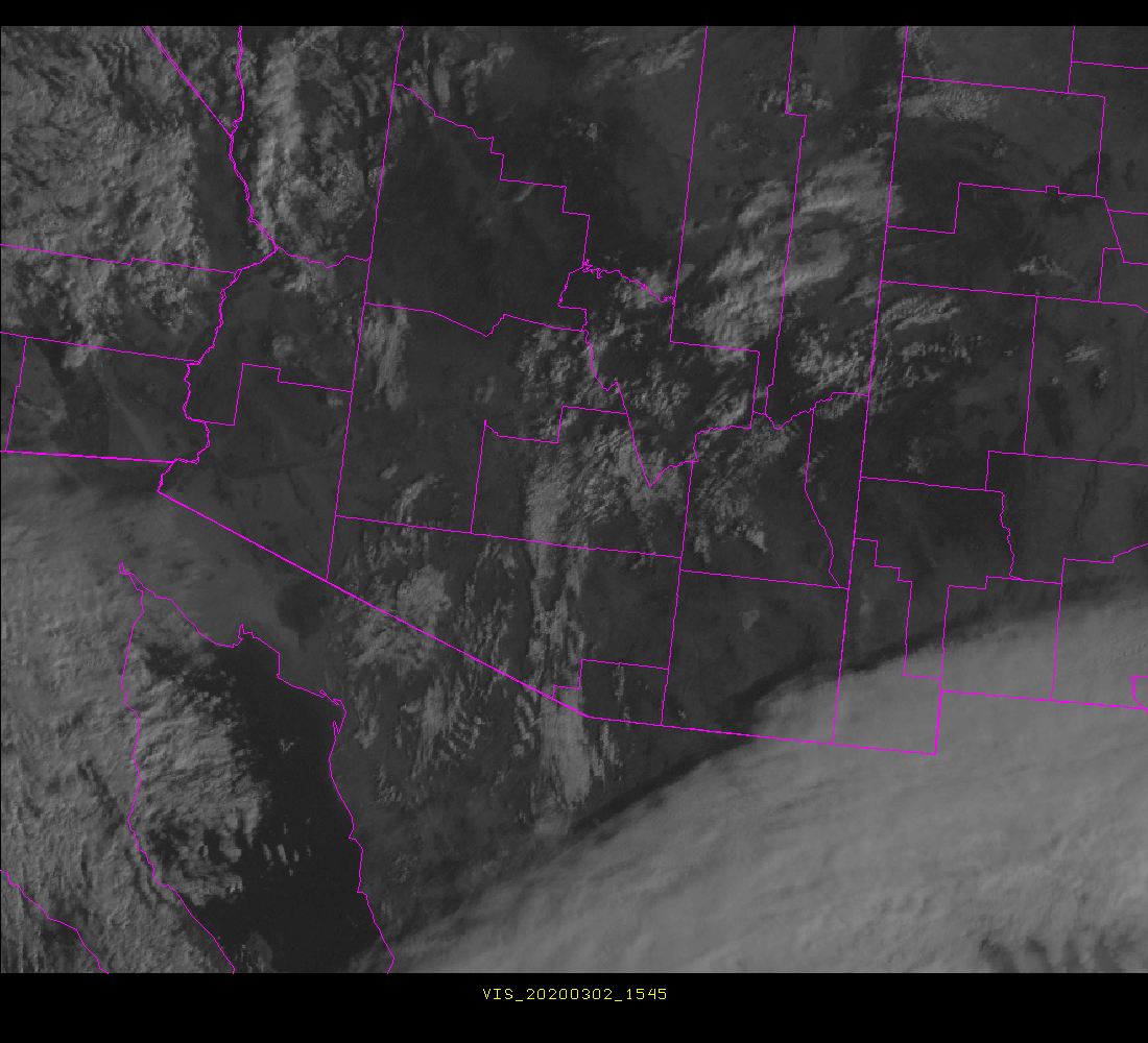
All the comments are relevant, but I have been upset with the lack of county outlines, which makes geographical interpretation difficult. As per old version (different day) below:


While it is nice to be rid of the black void at bottom of image, the county boundaries were very useful to me. I have searched various sites and the only image I can find with county boundaries is from NCAR, as per:


But this is not very useful since it's centered over Hermosilla, Mexico. If anyone can steer me to a nice visible sector for Arizona with county boundaries, please let me know.
----------------------------------------------------------------------
Since I'm going on about this, I must say that I really dislike the IR and WV sectors now and the link that Jack D. provided is much better, given greater flexibility. The NWS link to western IR now produces:


I really dislike this Funktop enhancement curve - perhaps because of multi-decade familiarity with the AVN curve. The Jack D link lets you chose the old color enhancement, as per:


Both the NOAA enhancements are of minimal use, since they don't quantify the temperatures that correspond to the colors - very sloppy science.