Saturday, June 21, 2025

Spring Summary


Yesterday was the summer solstice - the first day of astronomical summer and the longest day of the year.

Image above is from 4:35 pm MST on March 7th. Here is a brief summary of Spring (March, April, and May) here at the house. Precipitation occurred on only 6 days: 4 days in March totaled 0.59"; 1 day in April totaled 0.01"; and 1 day in May totaled 0.05", for a total of 0.65" during the Spring. I noted no thunderstorms here and no unusually strong winds. All-in-all it was a quiet Spring, that was the tenth driest since 2000.

Thursday, June 19, 2025

Look Ahead


View of the Catalias at 7:25 am MST this morning.


At 500 mb (above) this morning a large anticyclone is centered over northern Sonora, Mexico. The GFS forecast however (below), valid at 06 UTC on 24 June indicates a strong trough over the western U.S.


As the trough moves across our area, the GEFS plumes for QPF (above) indicate chances for showers at the airport from the 23rd on through the 27th.

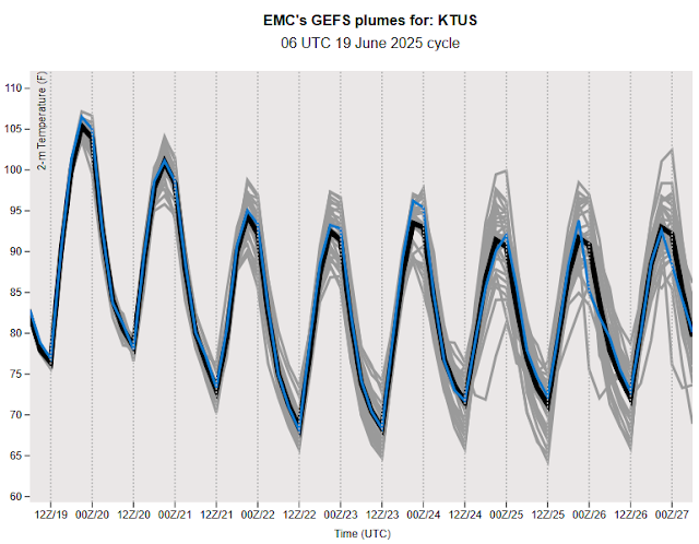
The plumes for temperature (above) indicate a cooling trend, after hot days today and tomorrow. The plumes for wind speed (below) indicate windy conditions tomorrow and Saturday, but with lighter winds the rest of the coming week. So, it looks like there is some chance for the summer storm season to start before the end of June - something we'll keep an eye on.

Erick Strengthened Rapidly


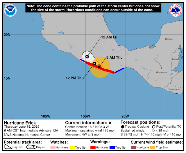
An IR image from 14 UTC (above) shows Erick's cloud masses after it came ashore early this morning in southern Mexico. The storm had intensified rapidly, briefly reaching Cat. 4 strength (113 to 136 kts), before coming ashore as a Cat. 3 storm (96 to 112 kts). Current outlook from the NHC (below) indicates Erick will weaken rapidly, before dissipating tomorrow.

Wednesday, June 18, 2025

Update

 Just a note - TS Erick was upgraded to a Cat. 1 hurricane by NHC early this morning.

Tuesday, June 17, 2025

TS Erick


Tropical Storm Erick developed around 3:00 am CST this early morning. The storm is forecast to become a Hurricane (below) and eventually strike the coast of southern Mexico.

Monday, June 09, 2025

Hurricane Barbara


The 1640 UTC visible image above shows Hurricane Barbara off the Mexican coast, with tropical storm Cosme further to the west. Barbara is the first eastern Pacific hurricane this season, The storm is forecast to remain a weak, Cat. 1 storm during its brief life. See the forecast below from the NHC.

Thursday, June 05, 2025

Hot And Dry


Pre-sunrise view this morning looking toward the south end of the Rincons.

Plumes from the 06 UTC runs of the GEFS members for temperature - remember the GEFS has a cool bias. Highs will hoover around a 100 F, or bit higher, for the coming week.


Plumes for wind (above) indicate a couple of breezy days later in the next seven days.

The 06 UTC GFS forecast for long-term rainfall through 06 UTC on June 21st (below) indicates no precipitation for almost all of Arizona. We will have to look forward to the start of summer thunderstorm season sometime around early July.

Monday, June 02, 2025

Occasional Showers Yesterday

Light showers looking toward the Rincons at 9:30 am MST yesterday morning.

Showers occurred here, off and on, from early morning to evening. The total here was 0.41", which is comparable to other amounts around the ALERT network - graphic below shows ALERT totals for the event.