Tuesday, February 12, 2019

Models Bounce Toward Wetter Event


Photo of Saturday sunset west of Chandler, taken by neighbor Jodi Ferner - looks like three cloud layers with lowest layer resulting in greenish hue, top left corner, portion of middle-cloud deck.

Another cold morning here, with a hard freeze (low at house 22 F).

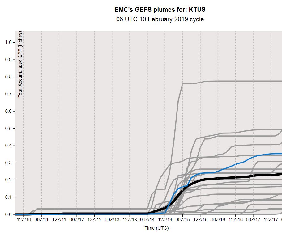
Forecast models continue bouncing around with their forecasts for Thursday and Thursday night. Current 06 UTC runs now wetter than were yesterday's. Above is GEFS plumes for rainfall amounts at TUS, while below is plot of probabilities of measurable rainfall during 3-hour periods.  


The WRF-GFS forecasts have changed in similar way in the 06 UTC runs at Atmo. Above is forecast (on 5.4 km grid) for PW valid at midnight on Valentine's Day, bringing the subtropical moisture plume eastward across most of southern Arizona. Below shows forecast total precipitation through 6:00 am MST on Friday the 15th, indicating a fairly significant event for most of the state.

Moisture plume currently far off of West Coast, between Hawaii and California, so need to keep watching evolution of situation next two days.


Monday, February 11, 2019

Models Trending Bit Drier This Morning


At 7:26 am this morning campus webcam shows band of low clouds from west across the Catalinas.

Down at bottom is photo of "hail" at Pebble Beach yesterday - although it was reported as hail, it may have been graupel. Nevertheless, two weather delays there kept the tournament from finishing yesterday.


The GEFS forecasts from 06 UTC last night are trending drier relative to yesterdays. The QPF plumes (above) show considerable uncertainty, both in timing and possible amounts, for the airport. from mid-week through the weekend. The PW plumes still forecast a significant increase, peaking on the 16th. However, most members are shifting the broad plume of subtropical northward into southern California, as per, the 06 UTC WRF-GFS PW forecast (second below on 5.4 km grid) that is valid on the 14th at 11:00 am. Clearly a "watch and see" situation for 14th through the 18th.


Sunday, February 10, 2019

Strange Dry-Out Yesterday And Quick Look Ahead


There was a precipitous drop in Td yesterday afternoon (from about 1:00 pm MST until a bit before 6:00 pm), as shown above in the T and Td trace above from ATMO. During the period of Td around zero to 5 F, the winds became west-southwesterly, but T did not change noticeably, nor did wind speeds which dropped slightly. A very strange episode that appeared to be localized from Tucson southward and westward (Nogales data showed this behavior). Data are very sparse to the west and southwest, and virtually non-existent for today and yesterday, as the RAWS observations are off-line.

Below is the 00 UTC plot of the TWC upper-air sounding (release time about 4:00 pm), taken during the dry event. The BL has three three slightly separate layers - but essentially it is well-mixed and very dry up to 600 mb. Apparently it managed to warm enough to develop this structure (which may also have been due to advection here from our southwest). Regardless, an unusual event occurring under heavily cloud-covered conditions.


Finally, the GEFS plumes for QPF at TUS are shown below (from the 06 UTC run). Many of the members are forecasting rain here on Valentine's Day (spread in forecast amounts is from nearly 0.80" to three members which forecast zero amounts). Although the trough associated with this is centered well to our north in the forecasts, the flow aloft becomes west-southwest with a long fetch from the Pacific, which brings in very moist, sub-tropical air. The degree and timing of the moisture plume will play the key role in determining timing and amounts of precipitation over Arizona.

Bit About Pebble Beach Tournament


The weather during the Pebble Beach tournament is often unsettled to downright nasty. Yesterday was wildly variable. Photo above of Phil Mickelson is early afternoon in wind, bit of showers, and cold. But photo at bottom is of Jordan Spieth during late afternoon finishing holes, when it had turned into a beautiful day. I can remember many years when the event was delayed due to nasty weather - including hail, graupel, and snow. Which leads to question: Why is a golf tournament scheduled so early in the year, during mid-coast California winter?

I checked around a bit and here's some history of the tournament. Originally this was the Bing Crosby Clambake sponsored by Crosby - featuring both amateurs and pros (which it still does). He had the early tournaments in San Diego. However, after several years the event became so popular that he had to move it so that it could be played out on several courses. Thus, he moved it north to Pebble Beach, where there were several championship courses very close to each other. 

Forecast today: showers, wind, and high around 50 F.


Friday, February 08, 2019

January Summary And Quick Look to Northwest

A bit late, but this is January 2019 summary for here at the house. Days with measurable precipitation 5. One day with a few snowflakes, but very short-lived. Total rainfall here was 1.02". Month was mostly quiet, with most weather action occurring during first week. Morning lows: days at 32 F and below = 13; days at 28 F and below = 6. Coldest morning was 22 F on the morning of the third. February has started out much as did January.


Nasty storm in the Northwest as strong short wave (500 mb analysis this morning above from NCAR) digs south-southwestard across Washington state. Forecast for Seattle calling for 4 to eight inches of snow through tomorrow morning. With the strong troughing over Northwest, the Pebble Beach PGA golf tournament (on the south side of the Monterrey Peninsula) is looking at a rugged final three days - rains and perhaps a bit of snow.

Forecast below is of total precipitation from the operational GFS for next ten days (below) is for period ending at midnight on February 18th.

Although California rain extends down coast past LA Basin, southern Arizona remains mostly dry, as just the tail ends of short waves brush across our area.


Wednesday, February 06, 2019

Chaff Streaks This Afternoon

First - rain event here at house ended about 10:30 am MST. Amount here was 0.25" and which makes total for February, thus far, 1.01".

For tonight the NWS has a hard freeze warning in effect (low of 28 F or colder). I checked the lows here at house and found that there have already been 8 hard freezes, during December and January this winter, here along the Rillito - not surprising since airport is routinely much warmer for morning lows than we are here. 


This afternoon I checked the radar and found that there was very strong echo out along the western edge of Pima County (above is KEMX composite reflectivity at 2:40 pm). This was likely a chaff plume coming off the test ranges. These used to be quite common, but I have not noticed a chaff event for quite awhile (the streaks of weaker echo between Ajo and Tucson are also chaff).


The radar charts here are from KIWA (above) and KYUX (below) with data from the base scans (both at 22:17 UTC). Looking at higher scans (available on the CoD weather page) the echoes were essentially gone at the third scans. I checked radial velocities (also at CoD) and found that velocities ranged from about 15 to 60+ kts (outbound from KYUX and inbound at KEMX). Velocities were highest for the strongest reflectivies - meaning that the high reflectivites were at higher altitudes than the weaker trailing plumes. A check of the hydrometer products at the CoD site indicated that the echoes were from birds or insects - the algorithms don't or can't specifically identify chaff.

At bottom is visible satellite image at 22 UTC, showing basically clear skies out where the echoes were present.


Cold, Rainy Morning Here


Another cold and rainy morning here - above view to north from campus was at 7:52 am MST. Down at bottom is view at General Store in Summerhaven, showing several inches of new snow up there.


Composite radar above from 7:32 am - first band of showers has moved eastward, while a post-frontal area of more showers is moving into metro area. ALERT rainfall measurements for this event below for northern portion of network. Amounts are generally light at this time. MIMIC TPW analysis for 12 UTC (second below) indicates that the plume of low-latitude moisture did indeed stay well to our south during the night.


Tuesday, February 05, 2019

Stormy Start To February Continues


Heavy, low cloud cover overhead and on the Catalinas at 7:35 am MST this morning.

There were some light showers here yesterday during the day that added 0.03", making total for day 0.25" and for event right at 0.75". So, quite a wet start to February.


Cold low at 500 mb has come ashore in northern California this morning (12 UTC 55 mb analysis above from SPC). Right now the trough to south of low is very flat, but this morning's forecast from the 12 UTC NAM (500 mb below, valid at 12 UTC tomorrow morning) indicates a marked sharpening of the southern portion of the trough as it moves into Great Basin and Southwest.


The current (12 UTC - above) MIMIC analysis of TPW seems to indicate that the low-level moisture plume will stay south into northern Mexico. If the approaching trough were to shift the plume northward, it would have significant impacts on precipitation amounts this side of the border. The 06 UTC forecast from the WRF-GFS (below on 5.4 km grid) shows model forecast precipitation through midnight on the 7th, with heavy precipitation to our north and also over northwestern Mexico to the south. Will take another look at the TPW later this afternoon and evening.


Monday, February 04, 2019

Quite Some Rain Event


First, a look at the ALERT rainfall reports. Above shows the rainfall for the six hours ending at 6:00 am MST this morning. Measurable amounts reported for entire network except fo 3 sites. The heavy amounts on Mt. Lemmon seemed a bit suspect, but I looked at hourly amounts (below) for Mt. Lemmon staring at midnight. So, it appears that just in last 7, or so, hours almost 3 inches of RAIN has fallen up on the mountain! Here at house 0.22" has fallen since midnight.


These two ALERT plots show rainfall for entire event as of about 6:30 am this morning. Above shows northern portion of network, while southern portions are below. Amounts have been surprisingly large locally. Total here at house has been 0.72"; at TUS 0.52"; and at DM 0.61". I suspect that the intrusion of low-latitude moisture that got into southeastern Arizona yesterday morning help considerably in producing the heavier amounts. Mt. Lemmon comes in with rainfall over 4 inches, and most of main metro area received 1/2 to 3/4s inches.


The 09 UTC plumes shown in yesterday's post (details there, but graph shown again above) seriously under-forecast QPF amounts in metro area, as did other forecasts. I certainly would not have gone for such large accumulations.

Just for background, the 12 UTC 500 mb analysis (below from NCAR) for this morning shows the deep low and trough continuing along the West Coast. This pattern has been producing huge amounts of snowfall in the northern California Sierras, and serious flooding along southern coastal sections. Looks like the trough pattern will bring us continued risks of showers through Wednesday.

Sunday, February 03, 2019

Showers Moving Into Metro Area


View from campus above shows showers moving into northwest metro area - composite radar below is from 7:30 am MST. Second below is this morning's MIMIC analysis of total PW from 13 UTC this morning. The system moving across Arizona and Great Basin has picked up a nice moisture intrusion into southern Arizona.


The SREF QPF plumes for TUS (above) are from the 09 UTC runs. Most members fore a morning precipitation event here, but a some keep rain chances going into tomorrow. Below is forecast of total precipitation through 6:00 pm tonight from the 12 UTC WRF-RR. Best rain accumulations forecast on Catalinas and to the north.

Looking around the Arizona observations, I see that most rainfall so far with this event has occurred over northwest third of the state. Flagstaff reported over an inch of RAIN!

Saturday, February 02, 2019

Ground Hog Day 2019


Visible satellite image from 14 UTC indicates Pennsylvania mostly covered with low clouds this morning.


And indeed, fearless prognosticator (Punxsutawney Phil) did not see his shadow - this supposedly means an early spring this year. That's news that was probably well-received in much of the Eastern U.S. Other photos indicate that crowds were large but well-bundled up in the pre-dawn cold.

If interested, map at bottom shows that this event took place in western Pennsylvania to the northeast of Pittsburgh.


Friday, February 01, 2019

Quick Look At Today


Weaking 500 mb cyclone will move across Arizona today (12 UTC 500 mb analysis above from SPC). Core of the coldest air appears to be nearly overhead this morning, and it has been associated with isolated thunderstorms during the night. There is CAPE in am TWC sounding and a bit of sunshine and heating this morning could produce a few more showers around eastern Pima County.

Composite radar below from KEMX is was at 7:00 am MST.


A few stations in ALERT network had light, but measurable rainfall during last 24-hours - mostly in and west of the Catalinas.

This morning's QPF plumes for TUS from the GEFSS forecasts continue to indicate chances for more significant events on Sunday and again during mid-week.