
In the previous post I had focused on the very large difference between the 500 mb forecasts from the GFS and ECMWF operational models out at 5:00 pm MST on January 20th. This is now only 96-hours out from 00 UTC last evening, and I show those forecasts here. These forecasts are now very similar, with the ECMWF trending toward the GFS solution, so that now the forecast 500 mb heights over Tucson for Wednesday afternoon are now essentially the same. The GFS appears to have prevailed in this situation.The short wave heading onto the Southern Plains in both forecast models becomes a major storm system by next weekend - see below.


Here in the Southwest we started January with a very typical El Nino pattern and had a wet period in the first week of the month (i.e., the 4th through the 7th). However, that El Nino type pattern quickly flip-flopped wrt to precipitation and has left us high and dry in southern Arizona. The above graphic shows the GFS operation forecast of total precipitation for the next ten days, ending at 5:00 pm on January 26th. The model forecasts threaten to leave us high and dry for the remainder of the month.
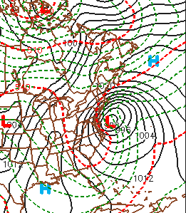
Finally, weather chatter this coming week will focus on the possibility for the first major Mid-Atlantic to Northeast storm of the winter. The models are forecasting a classic Noreaster to develop off shore from Friday through Sunday. The ECMWF surface forecast below is valid at 00 UTC on January 24th. The GFS forecasts are similar and a major storm may be in the offing; one that could alleviate the snow-drought that much of the Northeast has been experiencing. Impacts from such a storm, if it materializes, would be substantial but minimized some by its weekend occurrence.
No comments:
Post a Comment