
We have been away on a trip and just returned last evening - we drove north during the last phases of last Sunday/Monday event. Very interesting north of here, and I'll cover in later post (only 0.13" in gauge here from Monday afternoon).
This morning - early am webcam photo from Kingman, where very heavy snows have been occurring during night/morning - total water equivalent out there stands at 0.68". Down at bottom is General Store in Summerhaven at 7:00 am MST - showing an apparent skiff of new snow (this will make for interesting comparisons from the store as event progresses).
Just a brief overview here, since Mike L. has been covering the ATMO WRF forecasts in detail last couple of days.
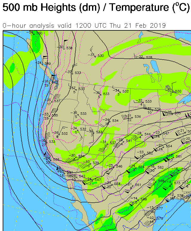
This morning's 500 mb analysis (above, from NCAR RAP) shows current position of western trough and indicates that cyclonic circulation seems present over southwest Nevada. Very cold air at 500 mb with this system as shown - temperatures colder than -30 C are widespread, with perhaps as cold as -38 C in core of circulation. Cold air and trough forecast to continue digging south, before heading east across Arizona tomorrow. This system brings a distinct threat of some snow accumulations across the metro area - appears bad for beginning of the big rodeo thing that starts today and goes into weekend.
The PHX (KIWA) composite radar (below) at 7:00 am this morning indicates most of precipitation still northwest of our area - but current local radar seems to indicate that some light showers maybe developing over northern portions of metro.


Current NWS forecasts are less aggressive with a slight chance of rain/snow mixed at airport after 2:00 am tomorrow night. Look forward to morning wrf runs and Mike's discussion!


No comments:
Post a Comment