
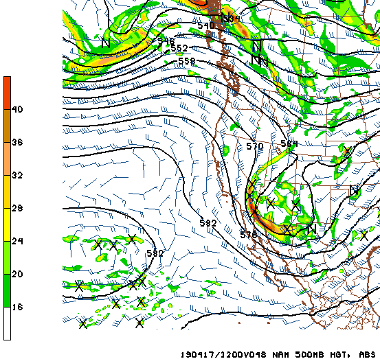
Will show a variety of model products this morning. Above is NAM 12 UTC 500 mb analysis this morning. The 500 mb short wave off of Washington coast is forecast to dig southeastward and impact Arizona. The 48-hour forecast from that run (below, valid at 12 UTC on the 17th) for Wednesday morning indicates the system closed-off over Arizona. The approaching system will bring gusty southwest winds this afternoon and tomorrow to our area, as well a chance for thunderstorms and light precipitation. This short wave is again moisture-starved, as per recent waves - no measurable rain here at house since the event of March 13th.


The 06 UTC WRF-GFS forecast (from Atmo) above forecasts very light rainfall totals for southeast Arizona (better amounts for mountains to our northeast) - however forecasts this morning are trending a bit wetter. Below is forecast TWC skew-T valid at 03:00 am MST on Wednesday morning - CAPE is about 150 J/Kg and PW is at 0.60". The forecast vertical structure is favorable for nighttime thunderstorms over our area.


Forecast from this morning's 12 UTC WRF-RR model run above is for composite radar echoes valid at 01:00 am early Wednesday. This run forecasts QPF of 0.10" at the airport. Forecast QPF plumes for TUS form the 09 UTC morning run of the SREF ensembles is shown below (from SPC page - note I goofed my clip some and amounts range from zero to a bit over 0.6" with average a bit below 0.20" - quite a large range for a moisture-short system (probably reflecting the possibility of thunderstorms at airport). However, there will be another period coming where there will be some weather to watch. Hopefully there will be enough rain to clean the air, after the gusty winds stir up some dust and abundant allergens tomorrow.

No comments:
Post a Comment