skip to main |
skip to sidebar
Chaotic skies over the Catalinas at a bit after 7:00 am MST this morning. Was delayed this morning and didn't get a post done, so this is a quick, midday look toward tomorrow.
Models continue to swing strong 500 mb trough across Arizona tomorrow - forecast above from 06 UTC GFS valid at 5:00 pm tomorrow afternoon.
Water vapor image at 11:00 am today shows a strong dry intrusion, ahead of the low west of California.
Forecast below is for total precipitation though 6:00 am on Thursday morning - from the 12 UTC WRF-GFS run at Atmo this morning. Forecasts look somewhat similar to the event at end of last week.
Beautiful, clear skies again today.
However, next system will affect us in a couple of days - morning forecast from NWS above. Below are the GEFS plumes from 00 UTC last evening. Plumes have been consistently forecasting around half an inch at airport from Wednesday into Thursday morning.
The precipitation occurs as a very sharp trough at 500 mb swings northeastward across Arizona. The GFS forecast above is valid at noon on Wednesday. Precipitation forecast from the GFS (below) is valid through midnight Thursday night.
The GEFS forecasts were too wet for last event, and recent runs from the WRF models at Atmo have been considerably drier with amounts at airport ranging from a trace to 0.20 inches.
I was too optimistic yesterday about clearing out from the west. Clouds and some light showers hung in all day, although some sun was also breaking through, as per afternoon view above.
Down at bottom is virus warning sign at LAX airport.
I've shown seven day rainfall totals from the ALERT network this morning (above and below). Totals are mostly from event just ended, although mostly light amounts from east part of network on the 8th are included. Our total here at house was 0.50" - which included 0.04" from the 8th.
Deep 500 mb trough will continue over the West through the coming week, as an Omega block persists from northeast of Hawaii north to Alaska. Forecasts from the 06 UTC GFS are shown here: above is at 84 hours valid at 18 UTC on March 17th, and below is 168 hours at 06 UTC on the 21st.
The QPF plume forecasts from the 06 UTC GEFS runs (2nd below) are consistent; forecasting next precipitation event here from Wednesday afternoon through morning on Thursday the 19th.
At a bit before 8:00 am MST there clearing skies to the west, but a few lingering showers over parts of metro area. View at bottom of Sawmill restaurant in Summerhaven indicates a bit of snow at end of event.
For unknown reasons current upper-air observations are largely missing this morning - so it's a bit hard to assess how widespread the morning showers may be, before the upper-air trough moves by later today.
ALERT observations for 24-hours ending at &:30 am (above and below) show that event was widespread - only Marana site indicating amounts less than 0.04" - problem at that gauge? Here at house we had 0.31" during past 24-hours, most falling after midnight last night. Amounts were generally greater to our northwest. Phoenix area had widespread amounts near and over an inch.
Satellite IR image above is from about 7:30 am MST - the upper and middle level trough is over western Arizona and southern California. Forecast below from 06 UTC GFS is valid at 5:00 pm this late afternoon and indicates the weakening 500 mb trough over Arizona, as a new and strong short-wave digs southward along the west coast.
The weekend should bring warm and mild and very nice weather, extending into early next week - enjoy.
Heavy clouds continue, but no rain in gauge here during past 24-hours. Very wet driving conditions on the Phoenix freeways this morning (bottom).
Most precipitation at ALERT sites past 24-hours was over northeast corner of the network - above.
Below is composite radar plot for about 8:20 am MST showing heaviest rains out in west-central Arizona.
Current NWS graphics and forecast for the airport, above and below.
Forecast QPF plumes from GEFS for airport (above) continue to be much heavier than forecast from WRF runs at Atmo (below from 12 UTC WRF-RR).
What will I find in gauge tomorrow morning?
Damp and foggy up in Summerhaven this morning - no snow on ground at the General Store.
Showers finally began here at house a bit before 6:00 pm MST last evening. Gauge here has 0.15" this morning. Amounts across ALERT network (above and below) were generally 0.15" or less and a few sites had less than 0.04". Greatest rainfall was up on Mt. Lemmon.
At 500 mb (above) the 12 UTC analysis indicates a closed circulation center near Vandenberg AFB, California, but with the larger trough extending far to the southwest. Satellite loops show a couple of circulation centers within the trough. Water vapor image below is from 7:00 am MST. There's a strong inflow of very dry air air from south of the circulation centers northeastward across southern California and into Nevada. This dry air could impact how things evolve over Arizona next couple of days.
The 06 UTC GEFS plumes for QPF (above) are now focussed on tomorrow and tomorrow night as a significant event for the metro area (average of plumes over 0.60" at airport). However, the 06 UTC WRF-GFS run from Atmo has a much different forecast (below for total precipitation through 5:00 pm on Friday the thirteenth). Note the very large, donut hole minimum centered just north of eastern Pima County and the zero amount at the airport.
Hope the outcome next couple of days favors the GEFS.
Rainy morning at the Prescott airport above. Rains in Arizona during the night have stayed well north to west of our area, and it will be interesting to see whether showers reach the metro area by afternoon.
The 500 mb charts here are from the 06 UTC GFS forecasts. Above is valid at 12 UTC (5:00 am MST) today, while below is for 12 UTC on Friday the 13th. The slow moving, closed low will be finally crossing Arizona by the end of week.
Above is IR satellite image from 13 UTC this morning, while below shows MIMIC PW from 12 UTC. Both indicate that the closed low is well west of San Diego (as per first 500 mb forecast above). The PW analysis indicates a broad plume of very moist air pointed toward the Southwest. This will be the first significant intrusion of subtropical moisture into Arizona for 2020.
At bottom is regional radar from 5:00 am MST, showing precipitation over parts of central Arizona north of Phoenix.
Heavy clouds with yesterday morning's rains have given way to sunny skies this morning.
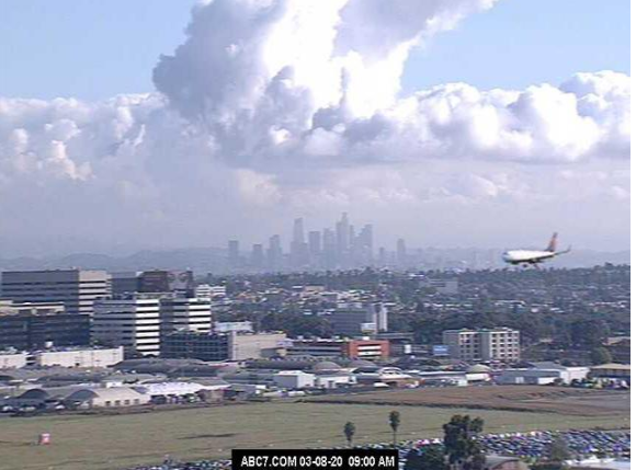
View down at bottom (from Jack Hales yesterday) shows plane on final approach at LAX with Los Angeles in background.
There was a strong southeast to northwest gradient across ALERT network (above) for yesterday's rain amounts. We were on the very edge here, with only 0.04 inches. However, MesoWest reports (below) show very heavy amounts across Cochise County (many sites set daily or March records).
At 500 mb this morning, Pacific closed low remains west of southern California. During coming week the low is forecast to shift toward northern Baja and then consolidate slowly northward (as per 00 UTC GFS forecast below that is valid at 5:00 pm MST next Sunday afternoon).
The meandering low and trough to our west bring a very wet week for us (at least in the forecasts). Above and below are this morning's NWS forecasts for chances of rain this week. Second below shows the 00 UTC WRF-GFS forecast from Atmo for rainfall totals through 5:00 pm MST next Sunday afternoon. If those amounts verify, it would be the wettest week here at the house in a very long time.