Yesterday's early WRF-GFS forecast was quite good for the local area. Model forecast storms westward to the Rincons and then just debris cloud west of the mountains. Pretty much exactly how the afternoon played out. Only 3 stations in the ALERT network had light showers (up to 0.12") during past 24-hours. One was on Redington Pass and the other two were in the Vail area. There are some light sprinkles and a patch of middle cloud to the south this morning, but nothing really substantial.
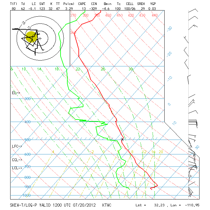
The morning skewT plot of the 12 UTC TUS sounding is shown above. There has been a slight increase in moisture near the surface, produced by weak outflows from the south during the evening. Precipitable water remains about the same as yesterday - at Tucson and across southern Arizona - with values a bit either side of 1.25". Deeper moisture and subtropical mT air remains south of border in Sonora. Winds aloft this morning are nearly light and variable, with a bit of easterly steering flow above 500 mb. I can estimate a tiny bit of afternoon CAPE for this sounding, but cloud bases remain up around 600 mb. The WRF-GFS forecast TUS skewT for 3 pm MST this afternoon (below) has increased middle-level winds, as an inverted trough at 500 mb approaches along the Borderlands. Forecast PW is only 32 mm (~1.25"). The surface lifted parcel yields decent CAPE, but it is an over-estimate for the deep mixed-layer that will be present this afternoon. My subjective estimate is again just a sliver of CAPE at low elevations.


The WRF-GFS forecasts some weak showers over eastern Pima County this afternoon (forecast composite radar echoes at 3 pm above). Total rainfall forecast through midnight is shown below. The model again forecasts best chances and amounts of rainfall on the higher elevations from north to east to southwest of the metro area. If the model forecasts verifies well, we could see light showers and gusty winds down here at lower elevations. If the PW were to increase nicely during the day, it would be a more optimistic outlook. It is of note that the model forecasts more storm activity approaching from the east near midnight - however, these storms also decay around the Rincons. Today would be an excellent day for an 18 UTC sounding at Tucson, and certainly a day to monitor the afternoon GPS PW trends.

No comments:
Post a Comment