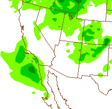
First - a wrap-up on Saturday's showers. Here at house we ended up with 0.09" for the first day of February. Across the ALERT network 32 of 92 sites had measurable precipitation, with amounts generlly less than 2/10s of an inch. One station, CDO at Big Wash, reported 0.63", but I suspect that there are likely problems with that report.
The two PW graphics above (top from CIMSS at Univ. of Wisconsin for 10 UTC, and bottom from CIRA at Colorado State for 12 UTC) show that the short wave across southern California currently has little precipitable water with it. Color bar is shown for the top and for the bottom product: brown indicates less than 1/4 inch and the shades of greenish-blue are from 1/2 to 1 inch of PW.
The midnight NAM forecast (below) indicated no precipitation for southern Arizona through midnight tonight. However, the early run of the WRF-NAM indicated light precipitation amounts from eastern Pima County on across southeastern Arizona. So, likely some virga, mammatus, and sprinkles or light showers for parts of the metro area and eastward today.
Monday, February 03, 2014
Subscribe to:
Post Comments (Atom)


No comments:
Post a Comment