Monday, September 14, 2015
Storms In This Part Of Town Yesterday
Storms appeared to develop along the Tucson Mountains yesterday and shifted a bit eastward into parts of the metro area. View above is of weakening storm along the Rillito at 4:26 pm MST - note that Jim Toth ( a couple of miles northwest of here) got over 0;75" from this storm with winds estimated over 40 mph. Here at house we were on the fringe of the storm and had thunder, winds of 35 to 45 mph, and 0.22", but the Dodge at Rillito ALERT gauge - less than a mile to east - had only 0.04".
Plot of CG flashes below is for 24-hours ending at 1;00 am this morning (from Vaisala and Atmo) and it shows several interesting things. First, the high elevation mountains had no thunderstorms yesterday - this happens a couple of times each summer and the reasons for this would make a nice research project for someone. Second, there were early morning storms up in Maricopa County and Sky Harbor actually got some rain - more on this below.
The ALERT map, second below, is for the metro-west sector of the network and shows the rainfall that fell in this part of town. Across the network 30 sites reported rain, and these were mostly in the west and southern portions of the network. The greatest amounts were 1.02" at the gauge at CDO Wash @ Ina, followed by 0.98" at the Santa Cruz @ Ina site.
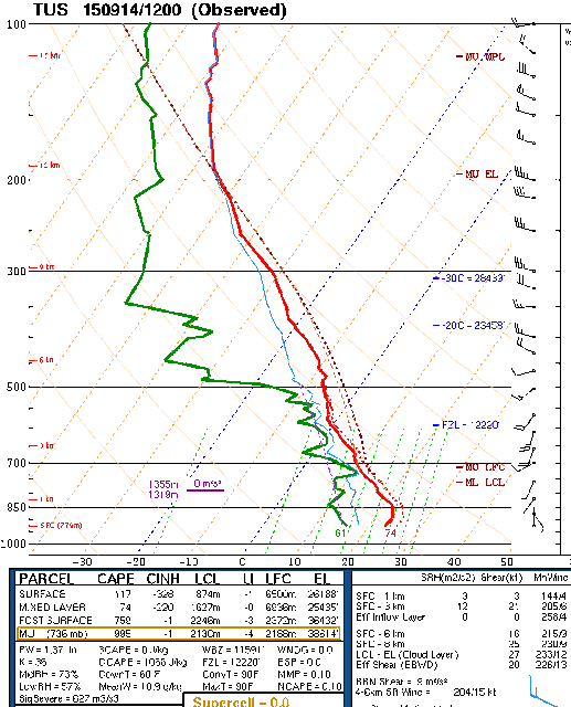
The skewT plot of the TWC 12 UTC sounding data is shown above (from SPC). The sounding exhibits a Plains-like wind profile that is often associated with severe thunderstorms. Dry air is moving in above 500 mb, but the lower atmosphere is still moist and there is still CAPE present. The south-southwest to west-northwest vertical wind profile is very typical of transition events.
What will the day bring? A difficult question to answer. I took a careful look at the 06 UTC WRF model runs but couldn't get a good feel for either version, since there were considerable ambiguities. The early morning activity in Maricopa County was more substantial than forecast by the NAM version, but not nearly as strong as forecast by the GFS version. Both versions do forecast isolated thunderstorms this afternoon but the details are not clear. I do note that both versions forecast storms to come into this part of town from the Tucson Mountains - having this happen on two consecutive days would be quite something. Beyond that, I'll wait for Mike's discussion of the 12 UTC forecasts.
Last question - Is this the final transition event that will usher in Fall? Again the models (global versions) are ambiguous and provide no clear cut answer as to whether the anticyclone will build back our way toward end of week and allow mT air to continue to seep into the Southwest from an active east Pacific.
Subscribe to:
Post Comments (Atom)


No comments:
Post a Comment