skip to main |
skip to sidebar
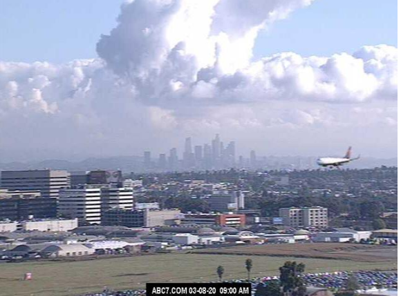
Heavy clouds with yesterday morning's rains have given way to sunny skies this morning.
View down at bottom (from Jack Hales yesterday) shows plane on final approach at LAX with Los Angeles in background.
There was a strong southeast to northwest gradient across ALERT network (above) for yesterday's rain amounts. We were on the very edge here, with only 0.04 inches. However, MesoWest reports (below) show very heavy amounts across Cochise County (many sites set daily or March records).
At 500 mb this morning, Pacific closed low remains west of southern California. During coming week the low is forecast to shift toward northern Baja and then consolidate slowly northward (as per 00 UTC GFS forecast below that is valid at 5:00 pm MST next Sunday afternoon).
The meandering low and trough to our west bring a very wet week for us (at least in the forecasts). Above and below are this morning's NWS forecasts for chances of rain this week. Second below shows the 00 UTC WRF-GFS forecast from Atmo for rainfall totals through 5:00 pm MST next Sunday afternoon. If those amounts verify, it would be the wettest week here at the house in a very long time.
Clouds and light showers around the area this morning, but also some blue sky peeking through.
Radar from about 7:10 am MST (above) shows most of the shower activity to the east and south of Tucson, and IR satellite image from 7:15 am (below) shows band of coldest cloud cover over Cochise County. Fort Huachuca has gotten 0.20" of rain so far this morning. There still could be some light showers/sprinkles in metro area this morning.
The NWS has issued a flood advisory (bottom) for this morning for the far southeast corner of Arizona - this means that could be localized flooding during the rest of the morning for that area.
Sunrise views: from campus above and from Cabo San Lucas at bottom.
The anticipated short wave for this weekend is now forecast to to minor-out rapidly, crossing Arizona tomorrow as a minor blip - 500 mb forecast above from the NWS GFS forecasts at 06 UTC last night.
The GEFS plumes for the airport from same model runs are below - these forecasts say maybe a sprinkle or two at most tomorrow with the better chances for precipitation toward end of coming week. Contrast these plumes with those shown in previous post - dramatic changes in chances for measurable rain at airport at very short time ranges! Not good, since we expect models to be more consistent at shorter time ranges.
The 06 YTC WRF-GFS forecasts for noon tomorrow also indicate a very moisture-starved system with the precipitation almost totally avoiding Arizona.
Will need to water our very dry yard/plants/shrubs/trees later today.
Rising sun reflected off of downtown Denver building above; Old Faithful and Teton Pass in Wyoming, two below.
The QPF plumes above are from the 00 UTC run of the GEFS models. Models continue to forecast showers on Sunday, but amounts range zero to 0.70 inches. Current NWS forecast this morning for Sunday is for 30% chance of 0.01" or more at airport.
More winds again today - past 24-hours winds have gusted to 65 mph at Mt. Hopkins RAWS site; around 50 mph at the telescopes on Kitt Peak and Mt. Hopkins; and 33 mph at the airport.
Another beautiful sunrise below at Cabo San Lucas.
Pre-sunrise, morning lights of Tucson (above) and Denver (below). Appears to be some thin, high cloud here, while Denver has a heavier overcast.
Mild and occasionally windy conditions will prevail here into the weekend. Current midlevel ridge over the West will shift slowly eastward, as a deep trough develops along the west coast bringing some chances for showers by Sunday.
The 06 UTC GFS forecast for 200 mb level (above, valid at 18 UTC - 11:00 am MST - on Sunday the 8th) shows both the main trough and a weakening short wave approaching Arizona. Note the very strong jet stream wind speeds over Arizona by noon on Sunday (red indicates speeds over 150 kts, or about 175 mph). At 500 mb (below, from same model run and also valid at 18 UTC on 8th) the short wave is more distinct.
Continuing with same model run - above is forecast for 850 mb winds and precipitable water (inches). The strongest push of higher PW appears again to be across Baja and into Sonora. Below is the forecast for precipitation during 36-hours ending at 5:00 am MST on Monday morning. Forecasts are indicating an event for southeast Arizona somewhat similar to that of early this week.
Clear skies have returned this morning, after the first weather event of March skirted by Tucson with little precipitation. Cochise County did much better with some amounts in Huachucas reaching over an inch of rain. Art Douglas reported 0.67" in Ash Canyon, south of Sierra Vista. Rest of week will be mild into weekend, but also windy at times.
Note view at bottom is today's sunrise seen from Bedford, Wyoming, which is a bit south of Star Valley Ranch in western Wyoming (from Jack Hales webcam wall).
Forecast above is from the 06 UTC WRF-GFS and is for 10-m winds valid at midnight tomorrow night. Model forecasts winds to continue into Friday morning, the 13th.
Here are three forecasts from the 06 UTC GEFS models. Above shows forecasts for temperature now through Sunday - a warm week until Sunday, when the next weather system comes by.
The ensemble forecast plumes for PW (above) indicate a significant spike in PW next Sunday and then they become wildly divergent after that - note huge spike in PW forecast by the operational GFS (blue). The plumes for QPF at airport (below) forecast an event for airport on Sunday but spread is large at almost an inch. Note that the operational GFS goes bonkers with large precipitation amounts at mid-week. For now, I'll just hope for a better event here next Sunday.
Heavy clouds over Catalinas this morning, as light showers and sprinkles affect the metro area. At bottom is photo from Nashville, Tennessee, where deadly tornadoes struck during the early morning hours.
Here in the Southwest, the 500 mb low (12 UTC analysis above) is about to move over Sonora, as forecast by the models last several days. Visible satellite image below is from from 7:40 am MST. Cloudiness over about the southeastern quarter of Arizona. Radar echoes from about the same time shown in second image below.
Rainfall reports (from MesoWest) for metro area above and southeast Arizona below. Very light amounts over the city - there's been only a Trace here. The most significant amounts have been over and near the Huachuca Mountains in Cochise County, where there have been a number of reports greater than half an inch.
View south from Kitt Peak early this morning shows some fog and stratus at lower elevations. View at bottom is sunrise on Saturday from northwest of Sonoita.
At 500 mb this morning (12 UTC analysis above from NCAR RAP) an elongated low is centered just northwest of San Diego. This low will swing south and east, moving into northern Sonora tonight and passing to our south by morning tomorrow.
Current outlook graphic from NWS above. Below is 06 UTC GEFS forecasts of precipitation for the airport - focus is on tonight and into tomorrow morning. Amounts are light, with the ensemble average forecasting about 0.15 inches at airport.
The forecast sounding for TWC above (from 06 UTC WRF-GFS run at Atmo and valid at midnight tonight) is moist to above 500 mb, but PW is only a bit more than half an inch. Precipitation amounts below are from same model forecast and and are valid through noon tomorrow. Event impacts mostly southeast Arizona and northwest Mexico.