First - yesterday had some thunderstorm activity in southeastern Arizona, especially along the Borderlands south and southwest of Tucson. Observed lots of thunder and lightning here at house but rain stayed on the north side of Rillito wash - as per usual.
Today's morning sounding indicates about 33 mm of precipitable water and some decent CAPE, especially over mountains. There are light and variable winds to above 400 mb, so this will likely be a day when storms form on mountains and then wander around wherever their outflows take them.
On the large-scale, the pattern has been changing significantly. At 500 mb the subtropical anticyclone has shifted far southeastward over northeastern Mexico. While from 300 to 200 mb it is not clear that there even is an over-land anticyclone, except over far south Mexico. Down at 700 mb there is an anticyclone over northeastern Mexico and a weak trough extends from southwest Texas westward to northen Baja. Very moist air lies in and south of this trough, with precipitable water values greater than 50 mm.
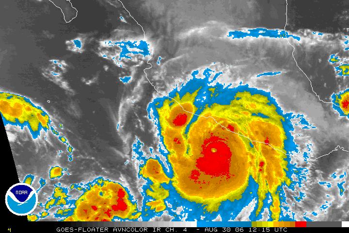
The big weather uncertainties are what will happen from now through Labor Day. Hurricane John (click for IR image) was found to be a Cat 3 storm by NOAA aircraft early this morning. Complicating the picture is the fact that nearby TS Kristy appears to be approaching hurricane intensity also. The two storms are quite close and it is not obvious to me how they will interact. There was a large ensemble spread yesterday, with the GFDL model actually predicting John would move up the Gulf of California.
The moisture surge situation becomes complicated if a strong hurricane moves into the mouth of Gulf or near the tip of Baja. Initially, the pressure gradient becomes north-to-south with low-level winds blowing across or down the Gulf. If the storm then moves westward, its winds and associated pressure rises can trigger the northward surge of moisture, or the storm can continue northward bringing its moisture field with it into the Southwest.
The current NHC forecasts indicate John to be moving from south of the mouth of the Gulf to near the tip of Baja as a strong Cat 3 hurricane on Friday. Thus, the situation is extremely complex and the timing of a strong push of tropical air into the Southwest is very uncertain. All of this complicated by the fact a strong cold front moves rapidly down the High Plains on Saturday and Sunday, trying to back-door into southern Arizona.
All that one can do with such a difficult mix of mid-latitude and tropical features is to watch the observations very very closely. Of course, most weather attention the next few days will be on the east coast events associated with Ernesto.
Subscribe to:
Post Comments (Atom)
No comments:
Post a Comment