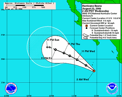
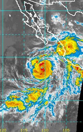
Hurricane Ileana has strengthened considerably since yesterday morning and has moved northwestward faster than forecast yesterday. Early this morning Ileana was a strong Cat 2 storm with estimated winds of 100 kt with gusts to 120 kt. The official NHC forecast calls for her to be located near 19.9 N and 114.4 W at 24 August 0600 UTC as a Cat 3 storm. The track forecast is shown in Fig. 1 IR satellite imagery from 1030 UTC (Fig. 2) this morning indicates that Ileana may be moving northward slightly to the east of the forecast track. Also of interest is the associated large mass of clouds and thunderstorms to the northeast of Ileana over west-central Mexico and also south of the Gulf of California. All of the above indicates that Ileana should trigger a significant northward surge of moisture that would reach into the lower Colorado River region by tomorrow morning.
However, the dilemma here is that high amounts of moisture and precipitable water are already present over much of the southwest U.S. So what impacts might be expected? I am going to guess that Ileana will result in increased moisture advecting into the lower Colorado River Basin, southern Nevada, and the southern California deserts. A distinct surface surge may be more difficult to detect, but one is certainly possible. Watch Art Douglas' surge index on the Creighton Univ. web page at:
http://whistler.creighton.edu/products/name/Yuma_Gulf_Surge_Index/
Subscribe to:
Post Comments (Atom)
No comments:
Post a Comment