Friday, October 29, 2010

Tomas Develops Off Northeast South America


Tropical Storm Tomas is currently off of South America near 58 W/11N and there are two active storms in the Atlantic, continuing a very active season (top image). Current Tomas IR image is shown in the middle graphic. Shary is forecast to pull rapidly northeastward and become extra-tropical. However, Tomas is forecast to move into the Caribbean and strengthen into a hurricane (bottom graphic).
-----------------------------------------------
Locally, as the cutoff in the East Pacific opens up and moves rapidly toward the Four Corners tomorrow, we can expect some more gusty winds. NAM forecast indicates a long fetch at 700 mb into Arizona tomorrow from low-latitudes of the Eastern Pacific. However, precipitable water over the Pacific southwest of here is quite low., with higher PW confined to the southern half of the GoC.


Wednesday, October 27, 2010

Large High Pressure Area

All the weather attention the last day or two has been focussed on the historically deep cyclone over the western Great Lakes region - see couple of previous posts. Now a large high pressure area will be covering much of the central U.S., bringing more typicall Fall weather. This morning's NAM forecast (850 mb forecast shown above valid 11 am MST tomorrow) shows that as the large high at 850 mb moves southeast from the central Rockies a strong east wind pressure gradient will develop across southern New Mexico and southern Arizona. This will result in a sort-of backdoor front, with gusty east winds developing by tomorrow morning. And that's about all there is to talk about here locally.

Monday, October 25, 2010

Art Douglas Reports Strong Winds

Art reports that winds have been gusting up to 36 mph over in Ash Canyon, in the southern Huachuca Mountains. I just scanned the observations in southeastern Arizona and found that most stations above 5000 ft msl are blowing at 25 to 35 mph. Gusts are higher up toward the White Mountains, with 40 to 50 mph winds. Strongest gust I found so far this morning in the TUS CWA was 51 mph at the Stray Horse RAWS. Of course this is pretty mild compared to what's evolving further north and east - as per post below.

Gray Morning Under Abundant Pacific Cirrus


"Mostly Sunny" skies have dawned gray and somewhat dreary under heavy cirrus streamimg in from the northwest, as a very strong shortwave at 500 mb moves across the northern and central Rockies. Top image shows morning view of Catalinas and middle image shows current, visible satellite image of the cirrus covering southern Arizona.
-----------------------------------
As the shortwave consolidates and moves east away from the Rockies, it appears that a Colorado Front Range windstorm is imminent, as well as a big blow for the western Great Lakes, as mentioned in an earlier post. Bottom image shows the current NAM 850 mb forecast for 00 UTC tomorrow evening. Very spectacular system with very low central heights. The surface forecast is now indicating a surface pressure with this cyclone of near 960 mb! Batten down the hatches across the northern tier of states.


Sunday, October 24, 2010

Beatiful Fall Day

It's a beautiful Fall day in Tucson. This morning's low here at the house was the coolest so far of the Fall. Low here was 42F compared to 51F at airport and 53F at Atmo on campus.
-------------------------------------
Speaking of Universities - I'm sure it's a glorius day in Columbia, Missouri, today, regardless of what the weather is!

Saturday, October 23, 2010

Late October Weather Misc.


Couple of things this morning.
---------------------------------
First, the top image shows a skew-T plot from U. of WY sounding page - Davenport IA, at 12 UTC this morning (Saturday Oct. 23rd 2010). The RRS sounding is quite a strange one. The sonde apparently had a bad RH sensor that measured almost no response to changes during the flight. Further, it has a large, warm spike near 0C that was likely due to water freezing on the thermistor, or inside the sonde package. An ugly piece of bad data headed into the archives.
----------------------------------
The models forecast a very significant storm to deepen over the Plains and move northward across Lake Superior by mid-week next week. The 500 mb and 850 mb forecasts from this morning's NAM run are shown in the bottom two images. At 00 OUTC on Wednesday it's forecast to be a very strong (surface pressure near 970 mb), wrapped up system and, if it materializes as forecast, will likely bring gales to the western Great Lake states.
----------------------------------
Thirty-five years ago (on Nov. 10th, 1975), the iron ore freighter Edmund Fitzgerald went down in Lake Superior during a similar storm, that had rapidly deepened and then moved into Canada north of Lake Superior. Canadian singer Gordon Lightfoot memorialized the ship, its lost crew, and the great storm in his well-known song, The Wreck of the Edmund Fitzgerald.

Thursday, October 21, 2010

Cool And Damp


While the cutoff low brought a big weather event to southern California, it has not produced much rain over southeast Arizona. Perhaps some more showers as it swings on by during the day today. So far it has been mostly a damping and a cool down. Top image shows Kitt Peak in the clouds this morning, and middle image shows the Catalinas with some low stratus hanging along the foothills and broken clouds above. Amounts of rainfall overnight have been quite light - could not even find a site in the southeast that had 2/10s" and most amounts have been around a 1/10" or less - 0.08" here at the house this morning. The change is nice, but a bit more rain on the ground would have been nice. The Pima County ALERT network had about 50% of measurable rain this morning and the gauges in the central metro area cane in with 80% coverage.


Wednesday, October 20, 2010

Situation Remains Muddled


The 500 mb cutoff low is currently centered along the California-Baja border (top image). The morning NAM forecast indicates that the associated vorticity maximum will have swung across southern Arizona by tomorrow evening. Precipitable water amounts over southern Arizona are currently less than an inch, and dry air at 700 mb and above lurks only a couple of hundred km south of the border (as per morning Guaymas sounding). So the impacts of this event over southeast Arizona will likely depend upon: how much moisture attends the core of the cutoff; how much warm, dry air at 700 mb may be pulled in ahead of the low; and how much instability will be present late tonight and tomorrow. Very tough forecast situation. Nice summation provided in the Tucson NWS 2:50 am FD:
-------------------------------------
DISCUSSION...UPPER LOWS ARE A WEATHERMANS WOE WHICH ALSO HOLDS TRUE
FOR THE COMPUTER MODELS. WATER VAPOR IMAGERY THIS MORNING SHOWED THE UPPER LOW OVER NORTHERN BAJA...OR JUST SOUTH OF IMPERIAL CALIFORNIA. ALL COMPUTER MODELS THAT I HAVE LOOKED AT THIS MORNING WOBBLE THE UPPER LOW NEAR THE CALIFORNIA/MEXICO BORDER INTO THIS AFTERNOON BEFORE UPSTREAM PACIFIC SYSTEM APPROACHING 130W GIVES IT THE BOOT INTO SOUTHWEST ARIZONA TONIGHT AND ACROSS SOUTHEAST ARIZONA ON
THURSDAY.
--------------------------------------
The morning Tucson sounding (middle image) indicates some small amount of CAPE present and this should increase - as long as the warm, dry air at 700 mb doesn't intrude northward across southeastern Arizona. The morning NAM forecasts that a north-south band of rainfall (bottom graphic for QPF during the 36-hour period) of up to a 1/4" will be centered out west of Tucson by the time the event has mostly ended at 5 pm tomorrow. So the NAM model apparently doesn't generate much CAPE from here east, although the model forecasts a significant rainfall event east of the Continental Divide in New Mexico.
--------------------------------------
So, even though the event is knocking on the door, it's detailed evolution remains somewhat unclear.
--------------------------------------
Jim Means reports regarding this event in the San diego area:

Hi Bob, I wanted to pass along that the cutoff low has been a MAJOR event for Southern California. Rainfall around San Diego county has ranged from about 1 to 3 inches. I've seen unconfirmed Alert gauges with readings up to 7 inches. We got a little lightning early yesterday morning but that was about it. I'm hoping for a little more today before the fun moves into your area.

Additional Comment On The Bad Flagstaff Sounding


BC comments further: Bob, it's more like a Stuve diagram, making it somewhat difficult to see superadiabatic rates. At least for me...
-------------------------------------------
I suspect that some readers may not know exactly what BC is saying here, since Stuve diagrams are not widely used today. The top figure shows a skew-T plot of the 00Z 8 September 2008 sounding for Tucson, while the bottom figure shows a Stuve diagram plot of the same sounding. There are at least three superadiabatic layers aloft in the Tucson data - one can be easily seen in the Stuve plot, but the other two are not nearly as obvious as in the skew-T plot.
---------------------------------------------
Thus, one must wonder why the RRS software provides only a Stuve plot. The skew-T plots are what NWS forecasters use in their operational diagnostics and quirks of the data are more evident. Perhaps the private sector contractors who developed RRS software weren't aware of NWS Forecast Office diagnostic procedures?


Tuesday, October 19, 2010

Models And Forecast Zig-Zagging A Bit


First - a beautiful Fall morning today on the University of Arizona campus and across Tucson metro (see top image).
------------------------------------------------------
The NAM forecast model (and the WRF) have been zig-zagging some on whether there will be rainfall in the lower elevations of southern Arizona as the 500 mb cutoff moves inland, and across Arizona, the next two days. The model forecasts yesterday were keeping the rainfall mostly to the north - i.e., drier forecasts than previously with low POPs. The runs overnight and this morning have resumed forecasting some rainfall here in southeast Arizona, although heaviest amounts stay north and on high elevations. The middle graphic from NCAR RAP shows the 500 mb cutoff to be positioned, at 12 UTC, over the Pacific, west-southwest of San Diego. Thunderstorms are active over the LA basin and the southwest California mountains this morning. The bottom graphic shows this morning's NAM rainfall forecast for the 24-hours ending at 5 pm Thursday afternoon. The Univ. of Arizona Atmo run of the WRF-GFS model at midnight indicated that the Tucson metro area would experience showers, and perhaps a thunderstorm or two, during the late night Wednesday and early morning hours of Thursday. Again, as per the WRF, amounts aren't heavy, but the convective character of the rainfall is delineated better in the WRF, with much of the metro area receiving only a Trace to a 1/10", while there are several narrow bands of heavier rain amounts forecasted.
----------------------------------------------------------
We'll now watch to see how things evolve the next 48-hours with this interesting cutoff.

Comment On Bad Flagstaff Sounding

bc has left a new comment on your post "Bad RRS Sounding At Flagstaff":

Bob, that's poor QC, plain and simple. Back in the olden days, observers would QC the data not by using algorithms on RRS but by actually plotting the sounding on a Skew-T. I believe that practice should resume.
---------------------------------------------------
BC - I guess that I thought that the RRS display system allowed the NWS operator taking the sounding to view the data in a skew-T like display - before the data were sent out to the users of the world. Perhaps I have misunderstood? Bob


Monday, October 18, 2010

Bad RRS Sounding At Flagstaff


This evening's sounding (00Z 19 October 2010) at Flagstaff (top image) is very strange and very bad. The strange, nearly saturated layer in lower levels jumps to very warm temps just below 500 mb. The sounding then appears to have a superadiabatic lapse rate for much of the rest of the tropospheric data. With only a quick look, I'm not quite sure what the likely explanation might be. But, the 500 mb plot for 00Z (bottom graphic) shows that Flagstaff data were plotted and that its temperature is 6 to 7 degrees C warmer than surrounding stations!

Another Fall Cutoff Low


I've been away for several days dealing with medical problems and am now back at work. Of note the past few days were the strong, high-based thunderstorms on Friday afternoon (October 15th). These produced light rains in the Tucson area but the rains came with very strong outflows - 52 mph at TUS, 68 mph at the Atmo rooftop anemometer, and I estimate 50 to 60 mph at TMC. There was one marginal severe storm report in the Tucson metro area.
-----------------------------------------
This week we're following another strong cutoff low at 500 mb. The water vapor imagery this morning (top graphic) shows that it is currently located south of San Francisco. The models forecast it slowly southward, before beginning to swing it northeastward toward central Arizona on Wednesday afternoon. The cutoff will bring heavy rains to southern California, especially tomorrow. This is the kind of cutoff that often brings strong storms and a threat of weak tornadoes to the LA Basin - so it will be interesting to see if 500 mb temps remain cold enough to produce thunderstorms in the LA area.
-----------------------------------------
The morning sounding at Guaymas, Mexico (middle graphic), shows that a northward push of quite moist low-level air is underway. The NAM model indicates a strong southerly fetch into Arizona the next couple of days, so lower-levels should moisten up (current surface dewpoints in sourthern Arizona - 40s to 60F at Yuma). The morning NAM foecasts also indicate that a backdoor front (currently moving southward down the High Plains) will move into southeastern Arizona by Wednesday morning, complicating the synoptic situation.
------------------------------------------
The NAM model forecasts little in the way of rainfall with this system across southern Arizona through 84-hours. The 60-hour forecasted rainfall ending at 12 UTC on Thursday morning is shown in the bottom graphic. Given the cold 500 mb temperatures with this cutoff and the influx of low-level moisture from the south, it appears that deep convection will be likely in southeast Arizona. The NAM model forecasts for southern Arizona may well be out-to-lunch this morning. I should note in closing that the strong system in early October pushed the very moist mT air far to the south, well beyond the southern end of the GoC. Thus, it doesn't appear that this current system will be able to pull mT air this far north.


Thursday, October 14, 2010

Unsettled Weather Returns To Southern Arizona


A 500 mb, cut-off low west of Baja has pulled moisture back into southern Arizona during past 24-hours, leading to high-based, afternoon showers and thundershowers. The top graphic is a visible satellite image for 3:45 pm this afternoon (Thursday Oct. 14, 2010) and the middle graphic is the Tucson composite radar image for about the same time. Most activity north of the border was from southwest of Tucson extending west toward southern California. This morning's run of the WRF-NAM model at Atmo predicted this scenario quite well - this run also predicts a considerable increase in shower and storm activity tomorrow afternoon. The bottom graphic shows an IR satellite image for 5 pm this evening that indicates considerably more, and stronger, storm activity to the south of the border over Sonora. During the next few days the Baja cut-off at 500 mb will pull eastward as a stronger short-wave digs south from the Pacific and cuts off over Arizona. Thus, unsettled conditions will prevail for the next seven days or so.

Rainfall Summary For Summer 2010


We have been away on a trip to the east coast and are now back in Tucson. Beautiful Fall weather out there in Rhode Island and a bit of Fall color showing especially on the maple trees.
--------------------------------------------
The following is the rainfall summary for Summer 2010 here at the house - where I'm calling June, July, August, and September "Summer".
--------------------------------------------
June - no measurable rainfall

July - 3.26"

August - 1.44"

September - 0.99"

TOTAL - 5.69" making 2010 the 5th driest summer since I started records here 13 years ago.
--------------------------------------------

Number of days with 0.25" to less than 0.50" 3

Number of days with 0.50" to less than 1.00" 1

Number of days with 1.00" to less than 1.50" 2

Number of days with greater than 1.50" 0

These six days (essentially 5% of the summer) had rainfall of 4.52", or about 80% of the total for the four months.
--------------------------------------------
The three days with the heaviest storms had rainfall of 3.37", or about 60% of the total for the four months. Further, these storms were very heavy and probably produced all of this rain during five hours or less - one event produced 0.77" in 20 minutes. Thus, the bulk of the rain (i.e., the rainfalls determining the character of the entire summer) fell in a time period that accounts for about 0.20% of the summer.
------------------------------------------
So, what does all this mean? As one might expect, the character of the summer, or a given summer month, for a location in the Sonoran Desert depends primarily upon how many heavy thunderstorms strike that location. Thus, monthly or seasonal averages of meteorological parameters actually provide minimal insight into why a summer (or month) was wet or dry at a given desert location [i.e., low elevation - elevations of around 1350 m (~4500 ft) or less - see above topo map].
-----------------------------------------
The meteorological factors that modulate the character of a summer in the Sonoran Desert occur on only a few days, and are those factors that lead to widespread, heavy storms, i.e., to the organization and propagation of intense thunderstorms on the medium to larger mesoscales.

Thursday, October 07, 2010

A Three-Body Scatter Spike Due To Large Hail Observed By Phoenix Radar


A radar-observed reflectivity spike extending from the far side of an intense thunderstorm was shown by Lemon (1998) to be the result of three-body scattering by large hail in the core of the storm. A very distinct example of such a spike observed by the Green Bay WI radar is shown in top image (snipped from Kurimski, 2010). A schematic (middle image) illustrating how the energy in the radar beam is scattered into the ground and then, eventually, bounced back to the radar receiver (also snipped from Kurimski, but originally in earlier work by Lemon) with the time delay from hail-to-ground-to-hail-to-radar producing the false echo extending out of the far side of the storm echo. Such severe hail signatures are very robust, and they are usually seen associated with central US thunderstorms. However, a rare example occurred here in Arizona on Tuesday afternoon. The bottom image shows the KIWA (NWS Phoenix) radar 0.5 degree reflectivity at 2335 UTC. The KIWA radar is just off the lower right of the image and the three-body scatter spike produced by the hail in the echo core (violet to white portion of echo) extends west-northwest out of the far side (left side) of the echo core. Storms producing large hail are quite rare in Arizona, and this is the only example of this radar signature that I've seen in Arizona.
-----------------------------------------------------
Lemon, L. R., 1998: The Radar "Three-Body Scatter Spike": An Operational Large-Hail Signature. Wea. Forecasting, 13, 327-340.
Kurimski, P. G., 2010: Radar Observations of a Rare "Triple" Three-Body Scatter Spike. Nat. Wea. Digest, 34, August 2010. This paper can be viewed on-line at:

Wednesday, October 06, 2010

Some Serious Overforecasting of Thunderstorm Threat Today


Have been away all afternoon and have just taken a look at the afternoon data. It appears that serious over-forecasting of the thunderstorm threat for southeastern occurred, well into the afternoon, by the NWS. Perhaps this is not surprising given the apparent moderate-level outbreak in south-central Arizona yesterday and this morning's tornado swarm (as per NPR) near Flagstaff.
---------------------------------------
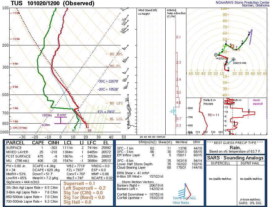
Top image shows the SPC diagnostic plot of the special 18 UTC sounding taken at Tucson. This sounding was a couple of mm too moist wrt GPS PW and, if one ignores the unrepresentative surface data, it has absolutely NO CAPE within the boundary layer - a serious decrease in storm potential from the morning sounding (see previous post). The hodograph is very nice, with substantial helicity (especially for down here!), but it needs some CAPE to do anything. However, the NWS forecast products continued to highlight a chance for storms with heavy rainfall and a chance for supercells and severe thunderstorms. The middle image shows the SPC severe thunderstorm outlook issued at 1938Z, after the special sounding.
---------------------------------------
Bottom image is the RAP regional radar composite at 2000 UTC this afternoon - this is as active as it ever was across southeast Arizona today - totally suppressed wrt deep convection.
---------------------------------------
The Univ. of Arizona, high-resolution, WRF models runs yesterday had indicated that today would be suppressed across southeast Arizona. The runs from this morning's data again repeated the forecast of no deep convection over southeast Arizona today. Mike Leuthold pointed this out in his morning WRF model forecast discussion, which proved to be right on!


Finally, Quick Look At Today


This morning's Tucson sounding (top) remains moist and very unstable in low-levels, with dry air above 600 mb. The wind shear profile is very favorable for severe storms. At 500 mb (middle) temperatures remain very cool over Arizona at -12 to -16C. Thus, at first glance there would appear to at least some threat of more storms today. However, model forecasts indicate little activity in southern Arizona today. The model forecasts rapidly advect drier air northward from Sonora, shifting the storm threat to the north. The current GOES PW image (not shown) indicates the presence of this very dry air in northern Sonora, so the models appear to be on track.
-----------------------------------------------------
The bottom photo is from John Diebold and was taken last evening as the intense arc of storms moved northward. Location is from west of the Tucson Mountains. John reported that power was out for several hoours over there due to downed power poles - so another severe report in the Tucson area.


Severe Storms In Central And Northern Arizona


Yesterday's outbreak of severe thunderstorms across portions of Arizona appears to have been the largest and most severe to occur in a number of years. The top image shows the SPC plot of severe storm reports for 5 October. There were 22 separate reports listed in Arizona with 8 reports of large hail and 8 reports of damaging winds within Maricopa County. The middle image shows an uncredited photo from the web of one of the thunderstorms moving across portions of Phoenix. Bottom image is the Phoenix Rainfall Index for 5 October. Note that there were a large number of reports of amounts greater than an inch. Yesterday's PRI for a single day indicates that about 50% as much rainfall occurred yesterday as fell during the entire period from June 15th through September 30th for the greater Phoenix area!
-------------------------------------------------
Intense thunderstorms continued this early morning in north-central Arizona with reports of tornadoes near the Flagstaff NWS Office which is actually located west of Flagstaff at Belmont, Arizona. The unusual early morning tornadoes resulted in a number of injuries, turned over trucks on I-40, and derailed a train, apparently on the Santa Fe railroad line (now BNSF).
-------------------------------------------------
Melissa Wagner of ASU reports the following about yesterday's storms -
My first hand damage accounts:

Golfball size hail in the NW valley; some houses near Glendale Public
Library were shattered from incoming hail. A friend in the region
described the hail as ice cube tray size.

At Flood Control District near the infamous Tent Cities:

Golfball size hail AND larger caused structural damage to seven cars
(meaning busted windows, broken mirrors and tail lights). Many if not
all the remaining cars in the lot had just the typical dents.
One guy (who recently purchased a new minivan) had the back and rear
windows busted out. Hail completely filled the backseats.
My husband's car had damage to side mirrors and the typical dents.


Storm In Southeast Arizona


Very active storm day yesterday and still continuing this morning; probably a bigger day than occurred anytime during the summer. First a focus on southeast Arizona - next post will deal with the storms in the Phoenix area and this morning's tornado just north of the Flagstaff NWS Office.
---------------------------------------------
Photos above are from just after 5 pm to about 6:20 pm (top to bottom) - Kitt Peak looking south (top); Catalinas from Campus (middle); and partial but double rainbow from house (bottom).
---------------------------------------------
Several rounds of storms yesterday from south to north across central portions of southeast Arizona. Heaviest storms occurred with a strong, east-west arc of storms that moved rapidly northward across the Tucson metro area around 7 pm. The rooftop anemometer at ATMO on campus recorded a gust of 85 mph with these storms and there was minor wind damage reported in Marana to the northwest.
---------------------------------------------
At 5 pm last evening 50% of the Pima County ALERT network had recorded rainfall during past 6-hours, but amounts had been mostly quite light, with a max report of 0.43". This morning 90% of the stations have recorded rainfall during past 24-hours with 12 sites reporting more than half an inch - max amount in the network was 0.75" up in Oro Valley area. Here in the Tucson metro area the airport had only 0.21", I measured 0.61" here at the house (0.47" with the storms around 7 pm), and ATMO measured 0.82". So, quite a nice storm and rain event down here in the southeast, but nothing like events further to the northwest, which will be covered in next post.


Tuesday, October 05, 2010

Cutoff Over Southwest Through 72 Hours


Summary of yesterday: There were some light sprinkles over central Tucson at midmorning yesterday. Numerous thunderstorms erupted by early afternoon, especially to the northwest of here in south-central Arizona, where there were a couple of marginal severe storm reports. Large storms also developed across Santa Cruz County and moved northward. When they reached to near Green Valley, they mostly crashed and shifted off to northeast. These storms threw out a very large, strong, and dusty outflow that appeared to result in a large are of subsidence over and west of the Tucson area. Thus, the afternoon and evening was devoid of storms over much of southeastern Arizona - the models obviously did not verify well for this part of state. Light showers and thundershowers developed well after midnight and moved through the Tucson area just before sunrise this morning. Again, the midnight model runs did not pick up on these showers either. Across the ALERT network about 80% of the stations of the stations had rainfall - mostly early this morning, although the southern stations had rain yesterday afternoon also. Amounts were quite light - 0.09" here at house; only 10 stations had amounts of 1/4" or more, with one station (Tubac) reporting a total of 0.51".
--------------------------------------------------
Top figure shows the dual cutoffs at 500 mb over the US - if interested, scroll down to the "Looking Ahead" post and you'll see that the ECMWF was vastly superior in the long range forecasts for this situation, when compared to the GFS.
--------------------------------------------------
Tucson sounding this morning was taken within the band of showers and is not representative of the larger-scale - temps were too warm and there was only a bit of CAPE. Other soundings indicate temps at 500 mb this afternoon of -10 to -12C. PWs are increasing over southeast Arizona and decreasing over southwest Arizona, where dry air has pushed in from the west at low-levels.
---------------------------------------------------
The SPC has a slight risk area over Arizona for today and a large area of strong storms is currently underway southeast of Flagstaff in the Rim Country. I also see a new storm has already developed over south Tucson - so looks like an active day.
---------------------------------------------------
Bottom two images show the midnight WRF and morning NAM rainfall forecasts ending near midnight tonight and both are very similar!

Monday, October 04, 2010

Interesting Weather Day Today


Looks like large-scale features are coming together for an interesting, and hopefully, wet afternoon and evening. The Tucson morning sounding is moist (see top image - PWs are 1 to 1/4" across southern Arizona), but with only a silver of CAPE. However, the NAM forecasts good southerly flow from Sonora by afternoon and 500 mb temperatures are very cool at -12 to -15C. The middle image shows the RAP analysis at 250 mb for 12 UTC this morning, indicating very pronounced difluence aloft. So, large-scale ingrediants are quite favorable for vertical motion and an active day, extending into the night. The NAM forecast for rainfall amounts for 12-hours ending at midnight tonight indicates a broad band of rains of 1/4" to more than 1" extending from southeast to northwest Arizona. Nice start to the week as the large Pacific cutoff at 500 mb develops along the Californina coast!