Wednesday, February 09, 2011
Hemispheric Pattern Change
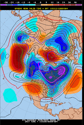
Shown above are the GFS ensemble, 500 mb, means from 00 UTC last evening for: 24, 84, 144, and 240 hours (from top to bottom). The models continue to indicate a pattern change in the Northern hemisphere, especially over the Pacific and North America. The strong ridge that has been persistent over the eastern Pacific finally shifts eastward over the continent, allowing a trough to develop and perist for a week or more along the west coast of the US. Also of note is the forecast deepening of the near-polar cyclone over Alaska and the redevlopment of a weak trough west of Hawaii - as per earlier in the winter. So, perhaps we will finally see a bit more weather possiblities here in the Southwest during the next couple of weeks.
Subscribe to:
Post Comments (Atom)


No comments:
Post a Comment