As the 500 mb short-wave trough over New Mexico heads eastward and the strong, cold system over the Northwest digs south today, the country is nearly covered this morning with NWS watches and warnings and special weather statements! See above - range is from a severe thunderstorm watch (TX and OK) to a blizzard warning (ID and WA).
The WRF-GFS run at Atmo at midnight, and the other forecast models, are forecasting gusty winds ahead of the Pacific Coast storm event. Above is WRF-GFS surface forecast for 4 pm Saturday afternoon. Looks like for second straight Saturday the air could be dirty with serious blowing dust and other sundry substances (see post for last Saturday morning down below). Also note above the warm temps with low dwpoints.
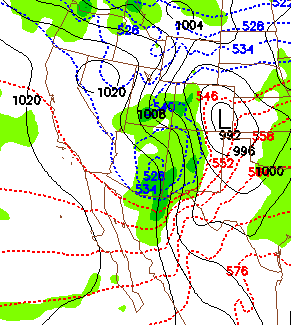
Finally, the NWS GFS continues to be the most agressive of the models for the weekend storm across southeast Arizona. The GFS operational member forecast for noon (from 00 UTC run last evening) on Sunday is shown above. All 12 GFS ensemble members now forecast a nice precipitation event for Saturday night. The forecast thicknesses appear cold enough for some flakes here at house, and would likely bring a covering of white to the Dove Mountain course for the finals of the Match Play golf tournament! We''ll keep watching as this event unfolds.


No comments:
Post a Comment