Thursday, July 04, 2013
More Re Yarnell Hill Wildfire - I
Above figure shows a regional radar chart from approximately 5 pm MST on June 28, 2013. The arrow points to the thunderstorm cell that produced the lightning strike responsible for the Yarnell Hill wildfire. Note that there were several mesoscale outflows present that were moving from higher to lower elevations (these are indicated by dashed lines). The Stanton RAWS station reported southwest winds at 10 mph (average for the past hour) at 4 pm, with the maximum gust during past hour reported at 26 mph. However at 6 pm the wind had switched to north-northeast at 28 mph with maximum gust during the hour of 43 mph. The mesoscale outflow on the 28th produced conditions very similar to those that would occur again on the 30th.
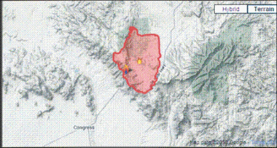
Map above shows detailed topography of the area where fire is burning. The highest elevation crest of the Weaver Mountains is indicated with dark-brown dashed lines. Yarnell (large black dot) is just north of a pass through the mountains, which Highway 89 follows. The topography would tend to funnel cold, stable outflows through the pass area and also likely accelerate wind speeds. The graphic below, from the 9 am incident report this morning, shows the area of the fire, which was 45% contained at the time of the incident briefing..
Subscribe to:
Post Comments (Atom)


No comments:
Post a Comment