
This morning from Jim Means, east of San Diego near Alpine, with Julian, California at the "A":
Hi Bob,
There were some pretty impressive rainfall totals in San Diego county yesterday. Several desert and mountain sites recorded more than 3", and the Pine Hills RAWS station, near the mountain town of Julian, had 4.42" on Sunday. That was enough to cause widespread flash flooding in the desert washes.
At my house--despite making into a flash flood warning box last evening--only got a few drops. We're getting a few more this morning. PW values remain very high, and if we could get any heating we could get some very good storms today, too, but the widespread cloudiness might keep amounts light.
Looks like a good week over here anyway.
Jim
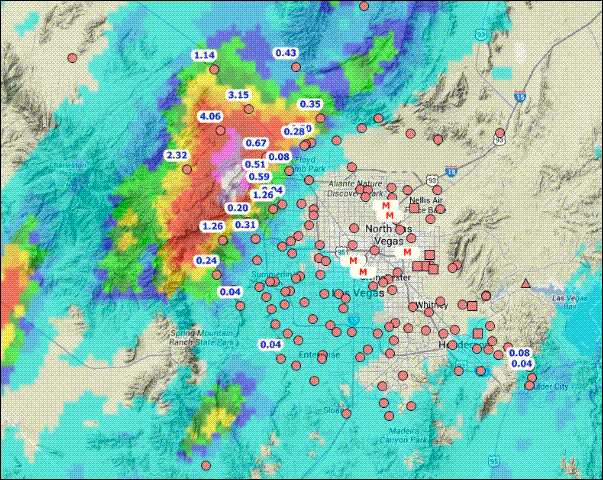
Yesterday Jim Steenburgh posted to MAP list, with above gauge and radar rainfall map, re storms just west of Las Vegas:
Mappers:
Several strong thunderstorms let loose on southern Nevada and California today. Attached is an image from the Clark County (NV) Regional Flood Control District web site showing the NEXRAD QPE (maximum > 8") for the6-h period ending just after 6 PM LT. One station north of the maximum reports 4.06" of rain. Mean annual rainfall at KLAS is about 4.5". If I am reading the tables on the Clark County RFCD web site correctly, a three inch storm has a recurrence interval of about 100 years in this area (presumably that is at any given location).
This map was generated at http://gustfront.ccrfcd.org/gagemap/gagemap.html, which is a really nice site and shows the incredible density of rain gauges available in southern Nevada. So many rain gauges, so little precipitation...
Jim
No comments:
Post a Comment