Yesterday was fairly suppressed in the Tucson metro area with activity remaining south along the borderlands. There were only 7 ALERT sites with light rainfall during the 24-hours ending at 6 am MST, and these were higher elevation stations to the east and southeast of metro Tucson. Heat continues with 7 straight days of high temperatures of 105 F or greater.
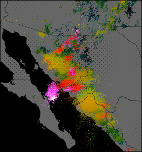
There was widespread thunderstorm activity in Sonora last night, as shown by CG plot above that is for the 12-hours of data ending at midnight last night. Southerly winds have pushed some recycled, low-level moisture north into south-central Arizona, as indicated by the CIRA blended PW product valid at 6 am (below)

This morning's Tucson sounding data (below from 12 UTC 20 August) has increased low-level moisture (PW just over 40 mm) and is the most unstable of the past few days. The wind field remains very chopped up however, with little in the way of steering flow. It is possible that if storms develop over the Catalinas that they will try to drift southward into town.
I looked quickly at the early runs of the WRF model but chose not to show anything from the forecasts because there appeared to problems in both the GFS and NAM versions. Both had forecasted PW valid at 12Z too low by 6 to 7 mm - so they both start out too stable. The GFS version had forecast way too much early morning activity and then forecast nothing over eastern Pima County during the afternoon. The NAM forecasts much more afternoon storm activity but keeps it south toward the borderlands. Of course, the low-level moisture that we've got this morning could also drift away, so it's yet another very difficult day for forecasting.

No comments:
Post a Comment