Tuesday, February 16, 2016
Perhaps Some Clouds And Sprinkles By End Of Week
The past week can be summed up as very warm to hot and amazingly clear. I scanned the week's worth of hourly images from the Computer Science web cam just a bit ago. The above image (this one from 3:00 pm MST on the 9th) dominates, with only a couple of views showing any cloudiness at all. The 6:00 pm image below, from Valentine's Day, captured the big weather event of the week, as some fairly thick, high cloudiness zipped by.
However, this morning's (Tuesday, February 16th) weather story from the NWS above actually indicates a 10% chance of measurable rain at the airport next Friday. This is the first time the airport forecast has indicated chances for measurable rain in many days.
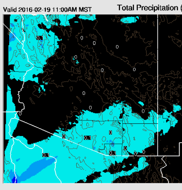
The 06 UTC run of the WRF model at Atmo forecasts some very light rainfall next Friday as some middle-level moisture sneaks in from the Pacific. Forecast above is from the WRF-GFS and shows total precipitation accumulated through 11:00 am on Friday. Certainly not much in the forecast yet, but a definite change from persistence. The forecast skew-T for the airport valid Friday at 11:00 am (below) is pretty dismal and indicates the bulk of the clouds and moisture in middle levels, with very dry air below 700 mb and especially below 850 mb. So, the model must be forecasting the development of some large drops for them to make it to the ground, perhaps melting graupel from around the 500 mb level. The WRF-NAM is considerably drier, but both models are indicating at least a brief change from our period of clear and hot days.
Subscribe to:
Post Comments (Atom)


No comments:
Post a Comment