Looking toward the Rincons at 6:30 am MST this morning.
Plot of detected CG flashes (from Atmo and Vaisala) for 24 hours ending at 0813 UTC this morning. It was a very active thunderstorm day across much of Arizona. Storms in our area occurred during the morning.
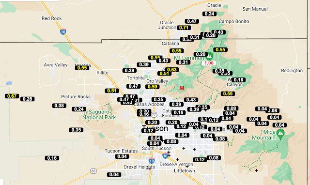
Plots of observed rainfall across the ALERT network (above and below) show widespread accumulations, with a number of sites exceeding half an inch. Here at the house we had a total of 0.27", which was first rain since the 1st. DM reported a Trace, the airport had 0.01", and Atmo measured 0.08".
The morning sounding from TWC/TUS (above) continues moist and unstable, with considerable CAPE. Winds aloft remain westerly through most of the troposphere.
Forecast precipitation totals (above, from the 06 UTC WRF-GFS) are valid for period ending at 5:00 pm tomorrow. Much of the metro area gets light showers, if forecast veriifies. Current morning forecast from the NWS (below) indicates 40/30 percent POPs for the airport this afternoon and evening.


No comments:
Post a Comment