Thursday, October 17, 2013

Question Re Long-Range Outlooks From CPC

First - today's temperature update. Low this morning at the house was 35 F versus 49 F at the airport official observing site. We are in a classic radiational cooling situation where morning lows are not well-correlated with elevation, since low elevation sites with drainage flow can be colder than high elevation sites. The closest RAWS stations (all higher to much higher elevations than here at house) mostly had warmer readings this morning: Sasabe - 35 F, Empire - 36 F, Saguaro - 44 F, Mt. Hopkins - 46 F, Rincon - 37 F, and Sollers (Mt. Lemmon) - 40 F.


An earlier post generated the following question: Hi Bob: It would interesting to see whether you agree with the NWS's 2, 3 months and out forecast. To a non-professional, the start of this fall portends a colder winter, not a 60% chance of above normal temps. These fronts that are coming direct from the Gulf of Alaska appear to be happening more often. Or am I misinterpreting what is going on????

I assume that the question refers to the various longer-range forecasts issued by the NWS Climate Prediction Center (CPC). I have posted their current NDJ three-month outlooks for temperature (above) and precipitation (below).

My basic answer is that I almost never look at these products, since they are so vague as to be almost meaningless. I have to admit that I don't know how these forecasts are generated, and I'll explore that issue some tomorrow.

When I do take a look at them, I usually end up scratching my head about some details. There was some controversy a year or so ago regarding the seasonal temperature outlooks. It appeared that CPC was "gaming" the forecasts to reflect the long-term trend in temperatures (the issue being what is long-term normal when there is are upward trends in temperatures, especially in morning lows?).

Another example of something puzzling is the "A" area below, indicating above normal precipitation for the three-month period over Montana, Wyoming, and parts of Idaho. What weather patterns would lead to this outcome? It does not seem to reflect more frequent or wetter systems coming into the Northwest. The only thing I can guess is that the area reflects more frequent, or wetter, upslope conditions and that whatever is causing this does not have a corresponding impact on seasonal temperatures, nor have much impact on precipitation to the east and southeast of higher than average area. This all seems strange to me, especially when what I am interpreting as "upslope" affects both sides of the Continental Divide.

In the shorter-term, CPC's 6-10 forecast does reflect strongly the current and forecast large-scale patterns over North America, as one would certainly expect.


Wildfires In Australia


An early start to the Australian wildfire season as serious fires are burning in New South Wales, near Sydney. Several booksellers in the Blue Mountain area have been posting blow-by-blow accounts, on a book dealer chat board, of the fires and evacuations.


The early spring has been hot and dry down there and the GFS, 00 UTC, 500 mb analysis below shows that a strong front crossed NSW yesterday. The front was dry, but accompanied by very strong winds that worsened fire conditions.


Wednesday, October 16, 2013

Very Persistent Ridge Over West Coast North America

First - coolest morning of the Fall so far today. Low hit 38F here at house versus 50F at the airport. Was actually cold when I walked at sunrise down in the Rillito Wash. Looks like low temps relative to the airport will be one of the few local weather topics for next week or so - see below.


Shown above is the 60-h GFS ensemble mean forecast  for 500 mb. The strong ridge over the western portion of North America extends eastward, at high latitudes,  into the north Atlantic. The ridge still persists in the 240-h mean forecast below, although heights have fallen over the north Atlantic. Weather will continue cool and unsettled over the eastern 2/3rds of the US, while the West is blocked-out wrt weather systems in the westerlies. Will October pass without rain here in the Southwest?


Tuesday, October 15, 2013

Sleeping Frog Farms - First Fall Frost


Sleeping Frog Farms reported in their last newsletter that the first frost of the Fall occurred there on the morning of October 6th (low here was 39F that morning). The Sleeping Frog is along the San Pedro River north of Benson - photo above. The frost was light but did cause some damage to sweet potato greens and peppers.

Art Douglas reports from Ash Canyon, south of Sierra Vista, include:

First frosts of Fall around Wilcox area and north on the same morning as reported above, which also had temperatures in low 30s in the San Pedro Valley to his east. Strong winds at his place (>40 mph) on both the 9th and 10th of October. Some nearby sites had winds over 50 mph and Art reports some wind damage to trees along and near the east slopes of the Huachuca mountains. Finally, he reported rainfall at his place of 2.33 inches for September, giving him a Jun-Sep total of 16.84 inches.

Monday, October 14, 2013

Octave And Now Priscilla Too


Tropical Storm Priscilla has developed to the south-southwest of TS Octave this morning. Current positions as per NHC shown above and a 1330 UTC IR image is shown below. Both storms are forecast essentially to move to the north during the next several days, impacting primarily Mexico. Forecast probabilities of TS strength winds for both storms are shown at the bottom.


Sunday, October 13, 2013

TS Octave


Tropical Storm Octave has developed in the eastern Pacific. Above is latest NHC forecast - which keeps it as a TS and moves it toward southern Baja as it decays into a remnant low. Below is IR satellite image from 14 UTC this morning, indicating quite a bit of conevtion to the northeast of the storm. Appears that westerly winds at base of western US trof will steer moisture associated with Octave into southern Baja, southern Sonora, and Sinaloa.


Friday, October 11, 2013

Dry Through Coming Week


The GFS operational member tends to be dry, but its forecast of 7-day total precipitation (above) for the period ending at 5 pm on Thursday the 17th of October keeps southern Arizona at the center of a huge void of rainfall. System that moved by yesterday is producing mostly rain over the northern High-Plains, which is probably a real relief for the Black Hills, which caught the brunt of the past blizzard.

Thursday, October 10, 2013

Event Heads Northeast


Today's weather "event" has pretty much moved away to the northeast. Above is visible satellite image from 1:30 pm and below is ALERT sector for Catalinas at 2 pm MST. Rainfall was light and limited to the Catalina Mountains here in eastern Pima County - pretty much as forecast by Atmo's WRF model runs the last three days. The model may have over-forecast rainfall out in central Pima County. Strong winds continue to the east of Tucson and the very exposed RAWS station at Guthrie has gusted over 60 mph. So, we ended up with wind and dust and no rainfall at lower elevations here in Tucson metro area.


Early Morning Update


Edited to add - 7 am MST web cam views of Kitt Peak (above) in the clouds and of Catalinas (below) with heavy, low clouds. Morning sounding shows a shallow cloud layer from about 800 to 700 mb. Morning walk was easier on my return with west wind at my back.


As the closed, 500 mb low moves into northwest Arizona, thunderstorms have returned to northeastern parts of the state. Graphic above shows lightning strikes during the six hours ending at 4 am this morning (10 October). Surface plot below is from 5 am and shows thunder, rain, and snow from northeastern Arizona into Utah and western Colorado. The Pacific cold front is just moving across eastern Pima County and at 5 am only 2 ALERT stations up in the Catalinas had reported precipitation.


Wednesday, October 09, 2013

A Political Aside


                       Header from Maureen Dowd's apocalyptic editorial of October 5th.

Quick Look AM 9 October 2013


The current short wave digging south toward southern California has not been able to advect subtropical moisture into it as of this morning. Above is CIMSS PW product at 9 UTC this morning and below is 12 UTC water vapor image - both indicate limited moisture for southern Arizona at this time.


The early run of the WRF-NAM at Atmo continues to forecast very strong south-southwesterly winds this afternoon (Wednesday, October 9th) for much of Arizona - above forecast of 10-m wind speeds is valid at 4 pm this afternoon. The model also forecasts a band of increased PW along the cold front tomorrow morning - the PW forecast below is valid at 9 am Thursday morning - note however that values stay quite low over southeast Arizona.


Finally, the model manages to forecast some rain at the ground out in central/western Pima County and the over the Catalinas. The forecast below is for total precipitation through 6 pm tomorrow evening - so much of southeast Arizona has winds and dust today and clouds and sprinkles as the front moves through tomorrow morning.


Tuesday, October 08, 2013

Windy Day Tomorrow


The early WRF forecasts from Atmo today (Tuesday, October 8th) continue to forecast primarily a strong wind event for southern Arizona as the next 500 mb closed low digs south into southern California. Shown above is the WRF NAM forecast of 10-m winds valid at 5 pm MST tomorrow afternoon. Below is the same forecast, on the 5.4 km grid, for the Southwest at 5 pm tomorrow. Strongest winds (> 40 kt) forecast over the southern California and Baja mountains.


Monday, October 07, 2013

Tropical Storm Narda


Tropical Storm Narda developed during the past day or so far southwest of the tip of Baja. The storm is forecast to move generally west-northwestward during the next several days, remaining far from land. Infrared image above shows the storm at 1930 UTC this afternoon and graphic below shows the current NHC forecast for the storm.


Strong Pacific Front Across Arizona Later This Week

First low temperatures - Yesterday was the first morning of the fall with a low temperature in the 30s here, with a min at house of 39F vs 50F at TUS. This morning, in contrast, lows held in the lower 40s at the house. But at the airport, TUS appears to have had a min temperature only in the low 60s - east-southeast winds prevailed at TUS during the night while things were calm here near the Rillito.


At 500 mb a closed low develops over southern California by 5 MST by Wednesday afternoon - above is 500 mb forecast from this morning's new NAM forecast valid at that time. By 5 pm on Thursday afternoon (below) the forecast low has opened up and moved rapidly east-northeastward. The associated vorticity maximum moves across northern Arizona, with strong winds likely ahead and behind the front. The current NAM forecast is quite dry for the southern half of Arizona.


However, several of the GFS ensemble members forecast subtropical moisture intruding into Arizona as the front moves through. The 5 am MST morphed PW product (below), from CIMSS at the University of Wisconsin, indicates the presence of two atmospheric rivers along and off the west coast, as well higher moisture over the southern third of the GoC. The evolution of these moisture sources will be important for the precipitation possibilities with this next weather system.


Sunday, October 06, 2013

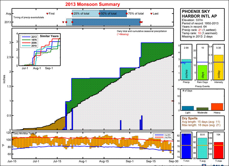
Detailed Rainfall Plots For Several Sites


Mike Crimmins (Univ. of Arizona - Dept. of Soil, Water, & Environmental Science) has developed a very useful web site for examining rainfall at a number of sites in Arizona and New Mexico. This information is at:
                             http://cals.arizona.edu/climate/misc/monsoon/monsoon_summaries.html

The perspective is Regional, but the data are presented in fine detail - as compared to say the fairly crude map presented in this morning's (Sunday, October 6th) Tucson newspaper. I've extracted the plots for summer 2013 at Phoenix, Tucson (above two), Douglas, and El Paso (two below).  These data are from the NWS observations at the airports in these cities. Phoenix ended up a bit above normal, while Tucson had a very down summer storm season (as I've been moaning about since the end of July). Douglas and El Paso were very wet this summer. But it is interesting that Douglas was extremely wet in July; whereas, El Paso picked up its heaviest rains during the second half of September during a significant transition event (this episode also produced devastating floods across portions of New Mexico and Colorado).    

At the url given above, Mike has provided a guide to the site and the data plots - enjoy.    


Saturday, October 05, 2013

Another Bobcat On The Circle


Our next door neighbor shot this photo of a large bobcat lounging on their patio yesterday afternoon. Outdoor pets beware.

Friday, October 04, 2013

Tornadoes This Evening


Large, wedge tornado (above) a bit over an hour ago near Wayne, Nebraska. Omaha base-scan radar from 6:10 pm CST (below), showing large supercell and hook echo east-northeast of Sioux City, Iowa.


Significant Storms Continue


Blizzard continues today in the Black Hills of South Dakota - above is from web cam at the Crazy Horse Memorial.

Santa Ana winds are blowing in southern California and statement just below is from the NWS Los Angeles office.

At bottom is visible image showing TS Karen in the Gulf of Mexico (center of storm circulation is just west of the deep convection - a bit west of 90 W). Karen will move ashore over the east-central Gulf Coast and bring some threat of heavy rains to much of the Southeast.


June Through September Rainfall


                             Early storms to the southeast, from here at the house - June 14, 2013.

Here are some rainfall reports for the past four months:

Holle (Oro Valley)                                  Jun  T   Jul  3.03  Aug  2.31  Sep  0.45  Total    5.79 inches

House (2979 E. Placita Santa Lucia)       Jun  T   Jul  0.83 Aug  0.68  Sep  1.04   Total    2.55 inches

Lyle (north of Broadway near                 Jun  .02  Jul  1.68  Aug  0.41  Sep  0.56  Total   2.67 inches
         El Con Mall)

Ertman (far southeast Tucson)             Jun  0.33  Jul  1.12   Aug  1.38  Sep  1.85  Total    4.68 inches

Santa Rita Abbey (NW of Sonoita)    Jun 0.30  Jul  5.28     Aug  2.63  Sep  2.22  Total   10.43 inches

Art Douglas (Ash Canyon)                 Jun  0.74  Jul 10.59   Aug 3.18   Sep  2.33   Total  16.84 inches

The totals here at the house for Jun - Aug and Jun - Sep are the driest during my 15-years of records here. The four-month rainfall was 2.91 inches in 2001 and 4.25 inches in 2009. So, a very dry summer season for the northern parts of the Tucson metro area.


                                        Santa Rita Mountains for the Abbey - August 10, 2013.

Thursday, October 03, 2013

Significant Storms - Elsewhere Of Course


Tropical Storm Karen has developed during past 24-hours and is now off the northeastern tip of Yucatan - above shows position this morning (Thursday, October 3rd). Below is the current forecast for Karen from NHC. The NHC forecasts Karen to briefly become a weak hurricane, before it goes ashore along the central GoM coast. Hurricane and Tropical Storm Watches have been issued. Weather attention the next several days will be mostly focused on Karen, especially given the forecast track.


Meanwhile, a cold, closed low at 500 mb is bringing snow to the northern Rocky Mountains this morning. The early WRF-GFS (at 5.4 km grid) forecasts the main snowfall from this storm to impact I-80 across southern Wyoming. The WRF-GFS forecast of accumulated snow through midnight Friday night is shown above.

Long dry spell continues here with breezy and slightly cooler conditions next couple of days.

Wednesday, October 02, 2013

Jon Talton Blog Re Yarnell Hill


Jon Talton (above) wrote an interesting blog entry on the day following the Yarnell hill tragedy. Jon is a journalist and also author of a number of mystery novels set primarily in Arizona. He is a native Arizonan. I am certain that he is not happy with the bland investigative report that has been released. The first two paras of his post are below - it can be read at:    http://www.roguecolumnist.com/rogue_columnist/2013/07/young-men-and-fire.html


Tuesday, October 01, 2013