Thursday, November 29, 2018
November Ends With Only Weather Event Of Month
Sunrise over the Superstition Mountains east of Phoenix (from Jack Hales web cam wall).
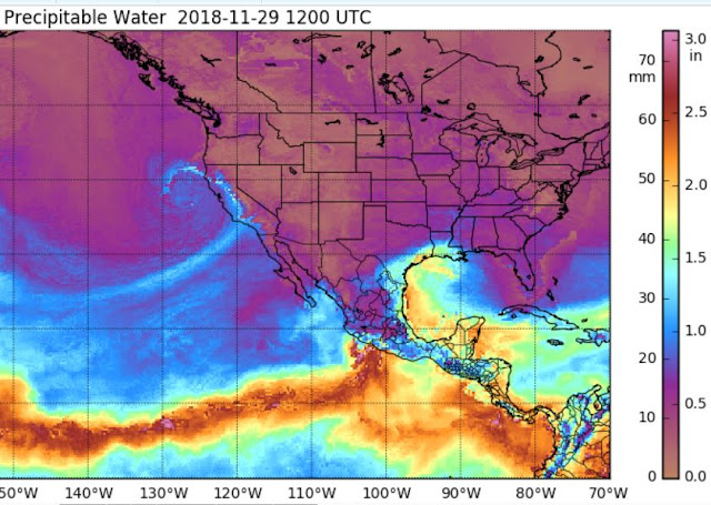
This morning the MIMIC toal PW analysis (above for 12 UTC) shows core of system approacging San Francisco. There is a distinct river of higher PW along the system's front, and light rains are already occurring over LA Basin. Model forecasts for PW at TUS jump it up to about 3/4 inch during frontal passage after midnight tonight.
The QPF plumes from 06 UTC GEFS (above - blue is operational GFS and balck is forecast mean) show all the members in tight agreement, with 100% of the runs producing a brief period of rain and about 0.20" at the airport. Forecast below (from the 06 UTC WRF-NAM) of composite radar echoes is valid at 03:00 am MST early tomorrow - note that model forecasts some echoes to have quite strong reflectivity cores. The forecast skew-T for TWC (second below) is for 02:00 am. CAPE is quite small and strong echoes are likely due to graupel forming in the 700 to 500 mb layer. Slightly more CAPE, however, would lead to some nocturnal thunder with the front.
The GFS version of WRF was wetter yesterday but today the NAM version is wetter. The NAM forecasts 0.3" at airport, while GFS version forecasts only a Trace. Compared to the GEFS forecasts above, WRF-NAM is wetter than any member, while WRF-GFS is a very dry outlier. Tomorrow morning we'll know which model came closest.
Subscribe to:
Post Comments (Atom)


No comments:
Post a Comment