
Cb over west end of Catalinas at 8:00 pm MST last evening. We had some thunder here a bit after 8 pm, but no rain.

Some reports of rain in north metro and Catalinas (ALERT map above for 24-hours ending at 7:00 am this morning). Heaviest amount was an isolated report of 0.39" over Keystone Peak southwest of the metro area. Composite radar plot from 8:10 pm yesterday (below) shows strong storm in northern part of city. Second below shows detected CG flashes (from Atmo and Vaisala) for 24-hours ending at 1403 UTC (7:03 am MST) this morning. Basically there was only one storm in eastern Pima County.


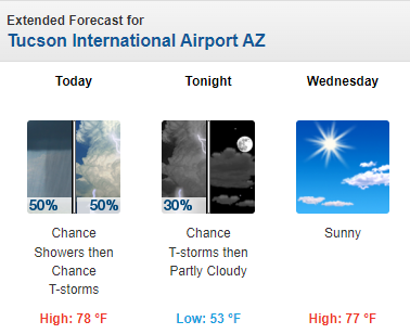
This morning's sounding from TWC/TUS (above) shows strong winds aloft and a small amount of BL CAPE. The 12 UTC WRF-RR forecast (below) indicates considerable precipitation across our region. The morning forecast from NWS (second below) calls for 50 percent chances for showers and thunderstorms today. Still hoping for some rain in the gauge here!

No comments:
Post a Comment