Clean, crisp skies this morning at 7:20 am MST, with only a few scattered clouds over the Catalinas.
Plot of detected CG flashes (from Atmo and Vaisala) for 24 hours ending at 1:03 am this early morning indicates widespread thunderstorm activity across eastern Pima County.
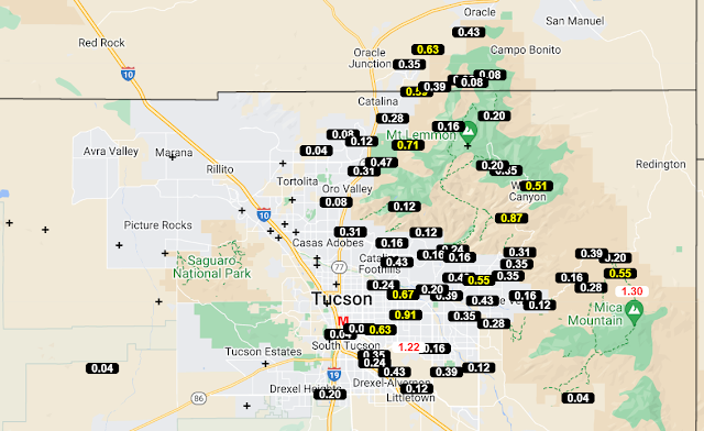
Data from the ALERT network (above and below for 24 hours ending at 7:00 am this morning) show widespread rain reports, except fr the northwest corner of the network. Many amounts were over half an inch, with three sites exceeding an inch. Here at the house we had 0.69", most of which fell shortly after 1:00 pm. DM reported 0.58", the NWS reported 0.19" at the airport, and Atmo had only 0.05". It was most rain here at the house since mid-July (0.82" on July 17th).
In the eastern Pacific Hurricane Otis (shown in IR image above just after landfall near Acapulco) intensified rapidly as it approached Mexico. The storm went ashore around 0625 UTC as a Category 5 hurricane with sustained wind speeds around 165 mph. Graphic below relates some details regarding Otis' strength. There was probably very serious damage across the Acapulco area.


No comments:
Post a Comment