This post is a follow-up to the previous post. After the model runs from 00 UTC data last evening, the ECMWF 500 mb forecast for 168 hours was further west and a bit deeper than was the GFS forecast for the same time - a bit of a flip-flop from the previous forecasts. It is interesting that from the time frame of 156 hours to 180 hours essentially all of the GFS ensemble members forecast precipitation over southeast Arizona. The ensemble POPs go something like 80, 100, 80% for these three long-range periods. The TUS NWS has gone a very bullish 40% POPs for TUS on day 7 (Monday the 19th). Other nearby NWS offices have "chance" or "likely" forecasts out for day 5 to 7 (depending on their locations). Chance and likely forecasts translate to POPs from 30 to 70%.
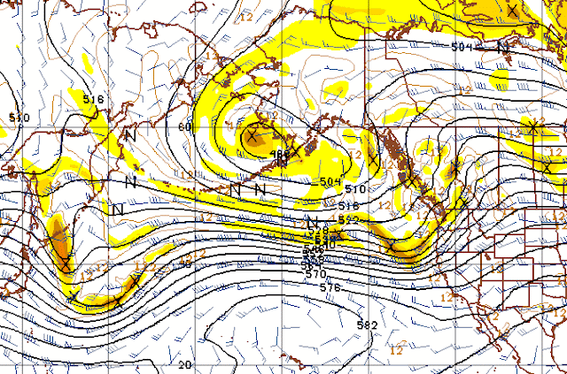
I've taken a look at the GFS operational member forecasts for 500 mb across the north Pacific. The 500 mb analysis for 00z last evening is shown below. At this time there was no distinct vorticity maximum clearly present that is forecast to be a player in the long-range. The red maxima over the Aleutians has a long tail to the west and the forecasts indicate that the maximum that will eventually dig down the west coast intensifies along this tail.
The 72-hour 500 mb forecast (below - valid at 00 UTC on 16 March) brings a distinct vorticity maximum off the Asian continent to just east of Japan. This shortwave is forecast to kick a ridge northward across the Gulf of Alaska, as it moves eastward. The vorticity maxima just east of the "528" contour label strengthens and begins digging southeastward , partially as a downstream response to the upstream ridging.
By 108 hours in the forecast cycle (below - valid at 12 UTC St. Patrick's day), the vorticity maxima of importance for the Southwest is forecast to be just off the central California coast. Several very long vorticity streamers are forecast to be feeding into this short-wave trough.
I find it quite remarkable that all the various long-range forecast models are picking up on a feature currently over Asia and making somewhat similar forecasts for our Southwest out at 7 days. Will continue to follow this interesting situation.
Tuesday, March 13, 2012
Subscribe to:
Post Comments (Atom)


No comments:
Post a Comment