Sunday, November 15, 2015
Light Showers This AM - Cold Mornings Coming
We have been away at Santa Rita Abbey (about 5 miles north-northwest of the highway intersection that is Sonoita) Friday evening and yesterday. The hills are in their winter browns with patches of green trees, but the cottonwoods at the Abbey were ablaze yesterday. Photo above is looking toward Mt. Wrightson.
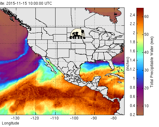
Watching the sky to the south yesterday, I noted cumulus appearing along the horizon around 10:00 am MST, and by 3:00 pm they had inched northward and extended almost to the Tucson metro area. The 10 UTC MIMIC blended PW analysis this morning (above from CIMSS at Univ. of Wisconsin) indicates a narrow atmospheric river extending northward to the northern California coast. Of more interest to us is the northward extent of subtropical moisture that now reaches into southern Arizona, much as the models forecast Friday morning.
Light rain showers are now occurring over much of southern Arizona - as per 5:00 am composite radar chart (above) from the NWS. Thunderstorms have so far remained along and south of 30 degrees north - as per plot of detected CG flashes during past 12-hours (below from Atmo and Vaisala).
The 06 UTC run of the WRF-NAM model at Atmo (second below) now forecasts a widespread precipitation event that is heaviest from the Tucson metro area northward and northeastward, with highest accumulations in the mountains. This forecast is very much different than the one I showed on Friday morning - the biggest difference being the large decrease in amounts forecast southeast of the Tucson area. Current NWS POPs forecasts for various grid points go like: TUS 60% (today)/30% (tonight); Mt. Lemmon 90%/60%; most of southeast Arizona east of Tucson 70-80%/40% including both the higher and lower elevations at spots like Mt. Hopkins, Art Douglas' place, Portal, Chiricahua National Monument, and Guthrie.
Quick update on early morning showers: between 5:00 and 7:00 am this morning 80% of the ALERT stations in eastern Pima County recorded 0.04" or more rainfall (Mt. Lemmon had 0.28" in those two hours), coverage of measurable amounts likely near 100%. Here at house 0.04", DM 0.04", Atmo 0.05", and TUS 0.06". So a widespread start of the precipitation this morning.
As the 500 mb short wave currently along the West Coast digs toward Arizona, temperatures at that level decrease markedly. The 500 mb forecast (above from the 06 UTC WRF-NAM valid at 6:00 pm tomorrow evening) shows temperatures dropping to around -27 C. Main impact of this cold air aloft will be several cold mornings next week. The WRF-NAM forecast of surface conditions over eastern Pima County (below) is valid at 7:00 am MST on Tuesday morning the 17th - the blue tones are near and below freezing. It appears that this forecast is picking up, albeit weakly, the cold zone along the Rillito Wash.
Note that, while there have been no freeze alerts yet for the metro area, here at the house we have already had four November mornings with lows of 32 F and colder, with frost on two mornings. Tuesday and Wednesday mornings this week should be down into the low to middle 20s F here.
Our interesting winter continues.
Subscribe to:
Post Comments (Atom)


No comments:
Post a Comment