Sunday, July 29, 2018
More Of Same
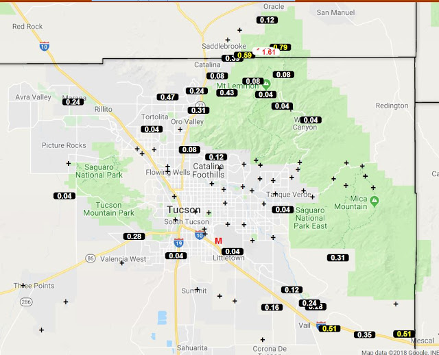
I'm off to a late start today. Fewer thunderstorms in eastern Pima County yesterday - a few weak cells in metro area but heaviest activity on north side of Catalinas (ALERT data above for 24-hours ending at 7:00 am MST this morning), and a severe thunderstorm in San Manuel with strong wind gusts and some damage. Lightning flashes again after dark, mostly to north, but nothing like the day before. There was anvil shading by late afternoon, as Mike L. warned yesterday. There was also a strong outflow from storms to south and southwest around 5:00 pm, with gusts of 30 to 40 mph. The airport had 0.02" and DM had a Trace - nothing at Atmo or here.
There was considerable thunderstorm activity between here and Phoenix during the early morning hours - the flash density plot above is for the 6-hours ending at 6:15 am, while plot of detected CG flashes below is for 24-hours ending at 1:00 am this morning. Parts of state were very active but mostly suppressed eastern Pima and Maricopa Counties. (Lightning flash data from Atmo, weather.graphics, and Vaisala.)
Composite radar chart above is from PHX at 6:43 am this morning. The early morning activity is leaving behind a mess of cloudiness over southern Arizona (visible image below from 7:45 am). Thus, both some low-level cooling and slow heating as negatives for today.
The 12 UTC analysis for 250 mb (above from SPC) shows the massive western U.S. anticyclone to be centered nearly over our heads. Stronger winds around the circulation in Arizona are across north portion of state.
The morning SPC sounding plot and analysis below shows that conditions today are much like yesterday. High PW and potentially high CAPE, but a very strange wind profile continues with light winds through most of troposphere, except for around 600 to 500 mb.
The WRF forecasts I've looked at (from 06 UTC and NAM version from this morning). Are forecasting storms much as yesterday, but with coverage over southern Arizona restricted mostly to Pima, Santa Cruz, and Cochise Counties. Storms around the metro area again mostly hug the mountains, as per yesterday. So it goes.
Subscribe to:
Post Comments (Atom)


No comments:
Post a Comment