Sunday, June 24, 2012
WRF-GFS Forecasts Strong Outflow For Tucson Metro
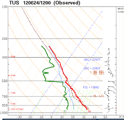
The early WRF-GFS forecast from Atmo this morning (Sunday, June 24th) is interesting because of the features that evolve over central and eastern Pima County this afternoon. The thing to watch will be whether or not the model has forecast the mesoscale details correct. The morning TWC sounding (above from SPC) was truncated at about 250 mb. But of note are the light and variable winds below 500 mb; however, the temperature at 500 mb is a cool -8C (but with warm advection possible during the day). My eyeball says that there is a small amount of CAPE possible at low elevations this afternoon - the WRF-GFS also forecasts some CAPE at TUS at 1 pm MST this afternoon. However, better CAPE is forecast over Santa Cruz County northwestward across central Pima County. By 2 pm MST the model forecasts strong thunderstorms in central Pima County (composite radar product below).
These storms produce a strong outflow (3 pm MST, 10 m winds below) that moves across the Tucson metro area from west to east during the mid-afternoon. We observe similar situations several times each summer, and I will be interested to see if the model forecast has these spatial details correct.
Although a second area of storms develops later in the afternoon over Santa Cruz County, the Tucson area is stabilized by the outflow, with only clouds and wind during the afternoon and evening. The total rainfall predicted by the model through midnight tonight is shown below. The model says close, but no rain here at the house, or at the airport.
Subscribe to:
Post Comments (Atom)


No comments:
Post a Comment