
Sunrise this morning from the Christmas Wash bridge on the Loop Trail section along the Rillito.
Plot of detected CG flashes (below from Atmo and Vaisala) is for 24-hours ending at 2:00 am MST this morning - thunderstorms were widespread across much of Arizona except for far western and southwestern areas. Much of Pima County had several periods of thunderstorms and rainfall.
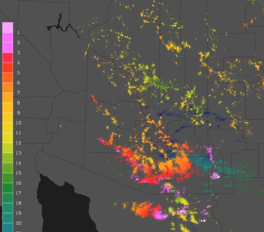

Plot of ALERT rainfall reports for 24-hours ending at 7:00 am this morning - north section above with south portion below. All sites had 0.04" or more, except for Oracle and Arivaca at the far corners of network. Heaviest amounts occurred near I-10 and also over south end of network. Here at the house we had afternoon storms and then another period before midnight - total of 0.39" here with just a bit of that after midnight; TUS had 0.37" with a thunderstorm gust to 56 mph; DM reported 0.33"; and Atmo had 0.49". Quite an event with eight stations reporting well over an inch of rain. Severe winds were reported again in Maricopa County, along with some large hail.


The 500 mb pattern (12 UTC this morning above from SPC) is extremely chaotic - heights have fallen and temperatures have cooled markedly, but there are numerous weak troughs scattered across the Southwest and northern Mexico. The sounding for TWC below shows that PW is down, along with substantial low-level cooling. Ignore SPC's worthless analysis of surface based CAPE and note that there is little mixed layer CAPE. The sounding, along with the cooling and widespread rain, should mean a down day at low-elevations. Two of three WRF forecasts from midnight and early this morning indicate this also.
But, rain in the gauge for the first two days of new month is nice relief from the dryness of the last week in August.

No comments:
Post a Comment