
An unusual sunset last night with lavender hues (above), while there was a more distinct orange to purple sunrise this morning (bottom).
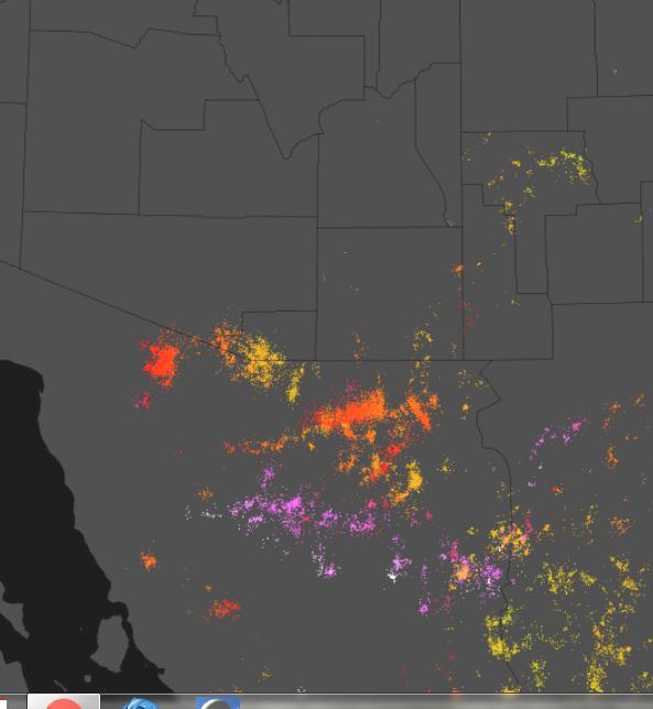
Thunderstorms yesterday were mostly southeast to southwest of Tucson (as per detected CG flash plot above for 24-hours ending at 12:30 am MST this morning - from Atmo and Vaisala). The interesting sunset colors were in the anvil clouds coming from Santa Cruz and a tiny corner of Pima Counties.
Four ALERT sites had rainfall of 0.04" and more last evening between 5:00 and 10:00 pm - these were the southern stations with very slight amounts, except Arivaca at 0.47". Nogales reported 0.45".

This morning Arizona is increasingly under the influence of the approaching West Coast trough - analysis of 12 UTC 250 level from SPC. A piece of that trough appears to extend down the GoC and will likely be an important player in today's weather events. Also of interest is the distinct Rex block over south-central U.S.
The morning skew-T plot of TWC upper-air data (below, also from SPC) indicates PW up to 1.75" in a very wet atmosphere. Winds aloft are better organized, veering from southeast at 600 mb to southwest in upper-levels. The old, surface based BL appears to have over 1000 J/Kg CAPE, but with considerable lift required to reach the LFC a bit above 700 mb.


The upper-tropospheric water vapor image above, for a bit after 7:00 am, shows the huge plume of moisture from south end of GoC north to southeastern Wyoming. Looks like very little solar heating during the day, so the approaching trough from GoC will be important for our local rainfall.
The model forecasts agree on rain today at TUS but possible amounts have large range. The 12 UTC WRF-RR (below) forecasts 1.2" through 6:00 am tomorrow morning (06 UTC NAM version forecasts 0.3" and GFS version is at 0.8"). This version of the model forecasts extreme amounts of up to over 6 inches on the mountains of Santa Cruz and Pima County. The 06 UTC GEFS plumes for Tucson indicate a QPF range from 0.2" to 1.25" through 6:00 am tomorrow.
Thus, a wide range of possible scenarios for the day - will sit and watch now. - I see that current radar indicates that a large thunderstorm has already developed west of Tubac - an interesting start.


No comments:
Post a Comment