Monday, March 16, 2015

More Winds Yesterday And Showers Later This Week


Yesterday turned out to be windier than expected - with many gusts reported into early afternoon in the 35 to 55+ mph range.  The above plot of winds with gusts in red is from MesoWest and was for 11:00 am MST yesterday.


The 500 mb closed low that is currently near the south end of Baja will move ascross northern Mexico tomorrow, as another weak S/W moves into the Southwest. The Baja system may produce some light showers mainly to the east. The trailing S/W however, is currently forecast by the WRF-NAM to bring more widespread shower activity to southeastern Arizona by Wednesday, the 18th. 

Forecast above is of composite radar echoes forecast for 11:00 pm on the 18th, while forecast below is of PW valid at the same time. The model's forecast for total precipitation through 1:00 pm MST on 18th is at bottom.

these forecasts are out at the end of 06 UTC forecast run and much can astray by the time they are valid - wait and watch.


Sunday, March 15, 2015

500 mb Closed Low Over Southern GoC

Was a very windy day in many locales yesterday. The airport reported gusts to only 28 mph, but up here along the Rillito wind gusts were considerably stronger for most of day - my estimates here were of gusts to 30 to 40 mph.

The 500 mb closed low centered over the mouth of the GoC this morning (NAM analysis above), has evolved about as predicted by various models. An approaching trough in the southern branch of the current split-flow regime will kick this low across northern Mexico by 5:00 pm MST on St. Patrick's Day (NAM forecast below). While the model forecasts a touch of light precipitation for southeast Arizona (forecast totals through 5:00 pm on the 17th at bottom), the main impacts will stay south of the border.


Cross-Country Contrast On The Ides Of March


Photo above from Ron Holle taken this weekend near Picture Rocks of Mexican Poppies contrasts nicely with web cam view of a bridge in northern Maine this morning.


Saturday, March 14, 2015

Book Festival Today And Tomorrow On The Ides Of March


Yesterday afternoon was characterized by high-based, light showers and sprinkles across eastern Pima County - view above is at about 5:00 pm MST. We had a couple of sprinkles here at house, along with a pleasant smell of rain in the air (Trace).


The WRF models run at Atmo continue to advertise strong and gusty east winds today and tomorrow. The morning sounding (taken at TWC on campus) plot above from SPC shows very strong east winds just above the surface layer. Just a touch of morning heating will re-establish the deep boundary layer and quickly mix the strong winds to the surface (vendor booths at the Book Festival are set to open at 9:30 am). There is a very strong, northerly jet stream (100+ mph) right overhead this morning.

The sounding is more stable than that of yesterday and WRF forecasts keep the showers off over higher elevations to the northeast and east this afternoon. The 7:00 am MST plot below, from MesoWest, shows surface winds with gusts in red - few sites are already gusting in the 20 to 30+ mph range. So, there may be flyers, brochures, and who knows what blowing in the wind at the Festival.


Friday, March 13, 2015

Bit Of CAPE For Friday The Thirteenth


This morning temperatures at 500 mb are quite cool (-19C), as a weak vorticity maximum digs southward across western Arizona toward the GoC. The cool temperatures combine with abundant sunshine today to produce some small amounts of CAPE this afternoon, especially over the mountains. The 06 UTC run of the WRF-NAM model at Atmo forecasts light showers over parts of southeast Arizona this afternoon (above forecast of composite radar echoes is valid at 3:00 pm MST this afternoon).

Main weather that will impact events this weekend will continue to be potential for strong easterly winds. The forecast below shows 10-m winds forecast for 9:00 am tomorrow morning - just when the Tucson Festival of Books will be starting up. Web cam view of east portion of University of Arizona Mall, at bottom, shows a beautiful and tranquil morning today, as tents are being put into place for tomorrow. The Mall is completely open to the east, so the winds will have maximum impact, since there will be no sheltering from tall buildings. Hope those running the Festival are keeping track of this potential problem and alerting all the vendors to batten down their displays.


Thursday, March 12, 2015

WRF Wind Forecast For Saturday


The seventh annual Tucson Festival of Books will take place on campus this weekend; it has become quite a big event during these seven years. While there is a slight chance of sprinkles here and there in southeast Arizona the next two days, the WRF-NAM forecasts strong easterly winds for Saturday morning. Forecast of 10-m winds below is from 06 UTC model run last night and is valid at 11:00 am MST on Saturday morning. Winds are always a worry for this event, since almost all the "booths" are set up in numerous tents, of varying sizes, that are spread up and down the University of Arizona Mall. So, something else to keep a weather eye on.


Wednesday, March 11, 2015

Western Pipistrelle Bats Return


Our resident Western Pipistrelle bats have returned (or perhaps come out of hibernation) and are active again, roosting between the adobe walls and two vigas on the front porch. This is about a month earlier than they appeared last spring. Hard to imagine that there are enough flying insects out now to sustain them. I call them "butterfly bats" because their flight reminds me of large butterflies. Four to six of them have made their summer home our front porch for about a decade.

Upper-Level Clouds Moving In From Pacific


The IR image above (from 0630 am MST) shows a broad band of cloudiness stretching from west of Baja to Wyoming this morning. Web cam view north from campus a bit after 7:00 am (below) shows that the metro air is a bit dirty and also that thin cirrus (and a number of contrails) are already present over our area.


Forecast above is from the 00 UTC run of the WRF-NAM (on the 5.4 km grid) and is for OLR valid at 6:00 am MST tomorrow morning (Thursday, March 12th). The model forecasts the thickest cloudiness to cross southeast Arizona during the night tonight and tomorrow morning. The cirrus will be thin much of today with abundant sunshine penetrating through. Forecast below is for solar irradiance valid at 1:00 pm this afternoon (from the 06 UTC run of WRF-NAM on the 1.8 km grid).

Cool morning here with lows in the 30s followed by afternoon highs up around 80 F - so very nice with abundant color breaking out everywhere.


Tuesday, March 10, 2015

Wide-Angle Views


A bit of a hodge-podge this morning. Above is an interesting hemispheric look at CG lightning flashes yesterday. This product is produced by Vaisala, but I'm not exactly sure how it is done - if anyone can steer me to an explanation, I would appreciate it. Of note yesterday were the very active thunderstorms over the Big Bend and adjacent areas. The small area plotted over central Canada is likely an artifact of the analysis procedures.


No winter weather highlights at all today (from NWS above) across the CONUS - most advisories and etc. are for heavy rain and possible flooding.


In the long term, the ECMWF develops an interesting pattern (above is 168-hour 500 mb forecast valid next Monday afternoon), with a substantial closed low west of Baja being pulled northward by height falls associated with the southern tail of a higher-latitude, Pacific trough. This pattern has brought several nice rain events to the Southwest during this fall and winter, and so is something to keep an eye on - but seven days is long way out, and models have been less than stellar past few months.

Monday, March 09, 2015

Second Week Of March Off to Mild And Quiet Start


Spring is well underway at many spots across southeastern Arizona. Above is a fruit tree in full bloom out at Santa Rita Abbey northwest of Sonoita. Very pretty, but it's a windy locale out there and the blossoms won't last very long.


Considerable thunderstorm activity has been occurring over the mountains of Mexico and graphic above shows CG flashes detected yesterday (March 8th) afternoon for 12-hour period ending at 9 pm MST. Note that Arizona is one of the few places in the U.S. that does not adopt daylight savings times - so times here will continue to be given in MST. Mexico and the Navajo Nation do go onto DST, so there are strange time switches if one crosses those borders.

The pattern for the next week will be stagnant, as a weak trough at 500 mb covers much of the southern U.S. and Mexico - below is the GFS ensemble mean and spaghetti plots for 500 mb for 168-hours from last evening. Considerable spaghetti over much of U.S. because of the weak character of the pattern.


Friday, March 06, 2015

Localized Gusty Winds Over Southeast Arizona

The winds are quite strong along the Rillito Wash this morning, with gusts of 30 to 35 mph, or a bit stronger. The current pattern is usually associated with very strong winds at Mt. Hopikins, and this morning the RAWS station there is recording strong gusts, with an early morning max of 82 mph. Here at the house there was a brief period of strong winds before dusk yesterday that were in the 40 to 45 mph range. Below is surface plot from MesoWest at 8:00 am MST - plot shows only local winds with gusts in red. Sheltered wind shadow west of Catalinas extends from Catalina and Oro Valley westward out to the north of the Tucson Mountains. Mt. Hopkins had calmed some to 59 mph.


The NWS link to MesoWest plots no longer works and gives you an error message - so the above plot came directly from:

http://mesowest.utah.edu/cgi-bin/droman/mesomap.cgi?state=AZ&rawsflag=3

Thursday, March 05, 2015

East Winds Today Plus Brief February Summary

Edited to add: Low temperature this morning here at house was 27F - coldest morning since January 24th, 2014.


The various WRF model runs continue again today to feature strong easterly winds for today and tomorrow - forecast above is of 10-m winds from the 00 UTC WRF-NAM run and is valid at 10:00 am MST this morning.

FEBRUARY SUMMARY

Very little to report from our location along the Rillito wash for the entire month. I measured only 0.04" of rainfall for the month, and that fell within less than one hour. Most other locations around the area had two days with precipitation and had more rainfall. Shown below are the monthly February totals for the east and west sectors of the ALERT network.


As for temperatures here at our cold location - it was a fairly mild month with no morning lows colder than 28F on the 25th. There were 22 mornings with low temperatures of 39F and colder, including 7 mornings with lows of 32F or colder. So very little to report for the entire month - March is already off to a better start.

Wednesday, March 04, 2015

500 mb Trough Moving Across Eastern Arizona This Morning


Significant cloudiness covers southeast Arizona this morning, as shown by 0715 am MST visible satellite image above. The 500 mb S/W is moving across eastern Arizona this morning (below is 12 UTC 500 mb analysis from NCAR), and there are light showers along and ahead of the trough.


The morning sounding from NWS TWC is plotted below (from SPC). Middle-level temperatures are colder than -20 C and moisture extends upward to above 500 mb. There is little resistance to vertical motion in the moist air and showers will continue until lower layers dry out during the afternoon. There may be a sliver of CAPE present in the sounding and surface heating, especially over the mountains, could lead to some thunderstorms during mid-day. After this system passes by the synoptic pattern over the Southwest becomes somewhat chopped up and ill-defined as we head into meteorological spring.


Tuesday, March 03, 2015

Brief Summary Of Yesterday's Event Over Eastern Pima County


View of Catalinas above is yesterday afternoon just before the Pacific cold front moved across metro area. Winds ahead of the front were very strong - estimated gusts of 40 to 50 mph here at the house. Rainfall was widespread with essentially 100% coverage over the ALERT network. There was one station see below that came in with 0.00 but that appeared to be perhaps a malfunction when compared to nearby gauges. The northern three sectors of the network are shown below - amounts were heaviest over the northern Catalinas and Redington Pass area with much lighter amounts across the City. We had 0.14" here at house.


Only thunderstorm activity in southern Arizona occurred far to the west (below shows detected CGs through 1 am MST today - March 3rd. As the showers passed through our area radar tops of the convection were in the range of only 14 to 20 thousand feet MSL.


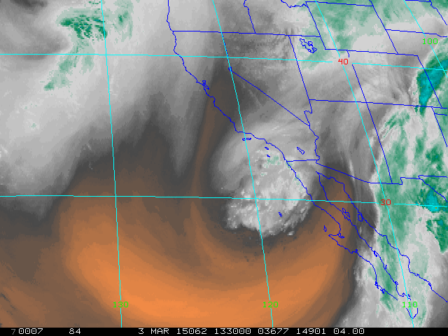
The trailing S/W has now closed off to the southwest of San Diego, after kicking yesterday's closed low rapidly northeastward - water vapor image above is from 1330 UTC this morning. This feature will open up and cross eastern Arizona and northern Mexico during the next 36-hours - NAM 500 mb forecast below is valid at 5:00 am MST tomorrow morning. The WRF-NAM forecasts some showers along the Borderlands as this happens with some activity as far north as eastern Pima County.


Monday, March 02, 2015

Early March Weather Event Still Approaching


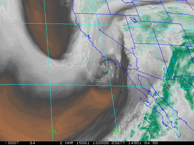
Water vapor image (above) from 12 UTC shows upper-level cyclone spinning west of San Diego this morning, as a trailing S/W digs southward toward it. The concurrent, blended PW analysis from CIRA at Colorado State (below) indicates that the AR that plowed across southern California and west to northern Arizona is now barely distinguishable, as a broad swath of tropical moisture is pulled northward - key question today is how much low-level moisture (mostly below 600 mb) will be pulled into southeastern Arizona before the event ends.


Radar echoes indicate most rainfall currently out along the Colorado River and extending into northern Arizona (above is Yuma composite radar display for 12 UTC this morning). Precipitation amounts exceed an inch at Kingman and the Grand Canyon (mostly snow so far), with Flagstaff reporting about 2 3/4" so far (mostly rain!). The 06Z WRF-NAM forecast from Atmo continues to weaken this event's impacts across southeastern Arizona - below is model's forecast of accumulated precipitation through the end of the main event (midnight tonight). However, yesterday's caution is still appropriate - model forecast soundings for metro Tucson during afternoon would support heavy, but not very deep, convective showers - so watch the radar a bit later today.


Sunday, March 01, 2015

Quick Look At Guidance Products/Forecasts


Only time for quick look at a couple of products re upcoming weather event. The graphic above is the QPF guidance from NWS WPC valid from 12 UTC this morning (March 1st) through 12 UTC Wednesday morning. The WPC's forecast amounts continue to decrease for southeastern Arizona as the event draws closer in time. The event, in their forecast, continues to be focused from San Diego across northern Arizona and into western Colorado. There is a secondary maxima forecast for northern Mexico.


For comparison I'll show the higher spatial resolution forecasts from the 00 UTC run of the WRF-NAM at Atmo. Above is the forecast on the 5.4 km grid through 12 UTC on March 4th and it is very similar to the NWS WPC guidance product above - almost looks as if the forecasters back there could have used this WRF forecast for their guidance.

Below is the same forecast but for the 1.8 km grid. Certainly the trend is not good for rain at lower elevations, with amounts over southeastern Arizona now focused on higher elevations in Pima County.

However, the event is still a day or so away (WRF forecasts main shower bands in Tucson area to occur tomorrow afternoon and evening). The soundings forecast for tomorrow afternoon for TWC are similar to other soundings this winter that produced nice amounts of rain - so we will need to keep an eye on tomorrow's evolution of the setting.