Monday, December 17, 2012
Looking Ahead To Christmas
About this time, during recent years, I start watching the GFS ensemble forecasts to get a feel for the variety of US weather being forecast for Christmas morning. Shortly (tomorrow?) NWS Offices will be adding a Christmas day outlook to their forecasts. However, this month the longer-term forecast models have been struggling out past 120-hours or so. Presumably, the less than stable forecasts reflect complex situations over the North Pacific, and at times very fast flow aloft. The GFS ensemble average for 500 mb at 12 UTC on Christmas morning is shown above. The average forecast indicates best chances for unsettled weather will be across the western half to two-thirds of the country. I haven't shown the spaghetti plot because, at this time frame, it indeed looks like a plate of spaghetti.
Here are some member forecasts of 500 mb at the same time. Member C000 (above) forecasts a strong and cold trough digging into the Southwest.
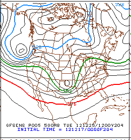
However, member P005 (above) forecasts a closed low over Oklahoma, which would bring wintery conditions to the Southern Plains and Mississippi Valley. This particular forecast also indicates a very strong coastal storm in the Pacific Northwest.
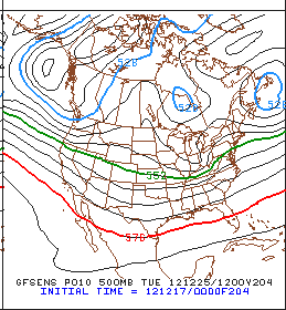
But, member P010 (above) forecasts a fast-moving, short wave heading from the Great Lakes into New England and another in the Pacific Northwest. So, right now it's a situation of very considerable uncertainty. Some parts of the country will likely have quite wintry weather on Christmas morning. Stay tuned as the final solution evolves over the next few days.
Subscribe to:
Post Comments (Atom)


No comments:
Post a Comment