First, a quick report on morning lows here in Tucson area - low at house was 25F. However, both my max/min thermometers were coated in ice at sunrise - so I'm not sure if readings were accurate. There was a moderate to heavy occurrence of frost here in the north part of the city. The low at the airport was officially 31F. The temperature here at the house was the same as the low on November 12th, with both days dropping to 25F.
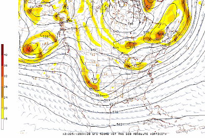
The GFS ensemble member forecasts for Christmas are now fairly consistent. The operational GFS 500 mb forecast valid 12 UTC 25 December 2012 is shown above, A short wave is digging some toward the Southern Plains and lower Mississippi Valley, with a weaker wave over the Great Lakes. The operational ECMWF forecast for the same time (below) is quite similar.
At the surface both forecast models are similar (GFS above and ECMWF below), with the main feature being a large, arctic high sliding south over most of the northern 2/3rds of the country. Cold and snow forecast for the upslope flow with this high and over the Great Lakes and rain and thunderstorms for the Gulf Coast. The ECMWF has forecast a more significant surface system over the eastern Great Lakes. Will check back on Christmas to see how the five day forecasts verified.
Thursday, December 20, 2012
Subscribe to:
Post Comments (Atom)


No comments:
Post a Comment