Friday, December 28, 2012
Cold And Unsettled For End Of Year
It is a picture perfect afternoon today (Friday, December 28th) in Tucson with bright, clear skies, as the Computer Science web cam shows above. Temperatures are in the 50s, after morning lows below freezing (26F here at the house). We continue to be in a pattern that is causing considerable uncertainty in the computer model forecasts - both short and long-term. The next storm was forecast to be somewhat warmer and perhaps with a subtropical moisture connection. However, the models are now indicating another cold storm event, and one with uncertain moisture influx from the southeast to southwest.
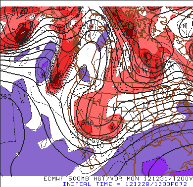
The two ECMWF graphics above are valid at 72-hours (i.e., at 5 am MST Monday morning, the 31st) for 500 mb (top) and 850 mb (just above). The ECMWF forecasts a trough over the Southwest that has two embedded vorticity maxima at 500 mb - one over northern New Mexico and the other over southwestern Arizona. Moisture at 850 mb is fairly widespread in the ECMWF forecast and 1000-500 mb thickness values are below 540 dm, which means fairly low snow levels. Thickness values of 534 or less usually mean snowfall into the Tucson metro area.
Similar forecasts from the GFS are below, for comparison. The GFS forecast emphasizes the vorticity maximum over southwest Arizona. Both models forecast a trailing vorticity maxima that is advecting southeastward beneath the ridge over western Canada. This is a complex situation with subtle differences between the two models at 72-hours - one to monitor closely, given the model uncertainty. Note that GFS ensemble members forecast precipitation over southeast Arizona for the 12-hours ending Monday morning in 10 of 12 members - a fairly high probability for precipitation some time on the last day of the year.
Subscribe to:
Post Comments (Atom)


No comments:
Post a Comment