First - Mike Leuthold's WRF forecast discussions will be posted at http://arizonawrf.blogspot.com/ this spring and summer. He did a post yesterday that keyed on the possibility of thunderstorms and winds this afternoon in Pinal and Maricopa Counties.
This morning's newspaper headlines actions by the ADOT after several crashes in blowing dust on I-10 east of Tucson. In this day of high-resolution observations, model forecasts, and grid point forecasts from the NWS (as well as inexpensive webcam capabilities), the ADOT will apparently implement a 1950s kind of action. They plan to change the I-10 speed limit from 75 to 45 mph along a stretch of the highway from Bowie to San Simon, Arizona.
Of course, the next traffic incident may well occur in some other dust-prone section of I-10.
Another closed low at 500 mb will swing across Arizona today, producing more unsettled weather for the last day of April. The 12 UTC NAM forecast above is valid at 5:00 pm MST this afternoon and indicates a quite strong vorticity maxima with this low. The current NWS Tucson forecast of maximum wind gusts expected this afternoon is shown below, and indicates strongest wind gusts along the Borderlands from Nogales east to New Mexico.
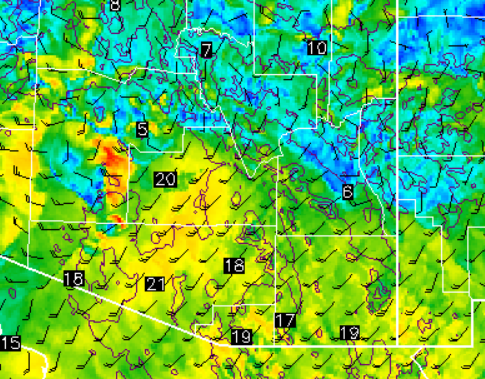
Last night's 06 UTC forecasts from Atmo's WRF model continue to forecast thunderstorms over parts of Pima, Pinal, and Maricopa Counties this afternoon. The forecast of composite radar echoes above is valid at 6:00 pm MST this afternoon (note that reds indicate storm reflectivities above 50 dBZ). The model forecasts strong 10-m winds (below, valid at 5:00 pm) from central Pima County northward into Maricopa County - red areas indicate wind speeds of 30 kts (35 mph) and higher with gusts likely increasing speeds substantially. If the model proves accurate, the infamous blowing dust zones between here and Phoenix may be active this afternoon.
Both the NAM and GFS versions of the current WRF forecasts keep the shower and thunderstorm activity to our north again, but with the Catalinas having some chance for storms. Although forecast CAPE (forecast skewT below is for PHX and is valid at 4:00 pm this afternoon) is small, storms would be high-based and with cold updrafts, favoring growth of graupel and perhaps small hail - thus the forecast of high reflectivities.
Our interesting weather continues, but the rain gauge here at the house remains empty except for dead spiders and dust.
Saturday, April 30, 2016
Subscribe to:
Post Comments (Atom)


No comments:
Post a Comment