Heaviest storms yesterday were out in the lower Colorado River Basin and also in the San Diego metro area - quite something. Many severe thunderstorm reports out there. Some heavy rains also occurring over in southwestern New Mexico.
There is considerable media frenzy going on with Jim C. of the Weather Channel setting up yesterday along the Rillito Wash trails, where I usually walk. I was half expecting to find Al Roker broadcasting from the Campbell St. bridge when I walked this morning, but he was a no show. I've seen people sandbagging residences - a first for me since I've been out here.
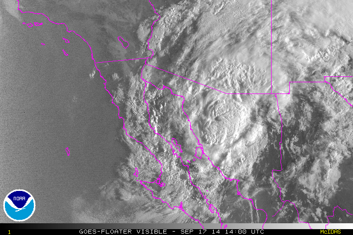
Odile is currently somewhere in the northern GoC, but with deepest cloud masses to east and northeast of the storm center. Visible satellite image above is from 7:00 am MST and does not show the center of the TS clearly. Below is the current NHC forecast for Odile and her remnant depression. This forecast brings the depression across central Pima County west of Tucson tonight, which would put us in the region of heavy rainfall.


Composite radar image from NWS TUS above is from 6:40 am and shows the first large rain band directly associated with Odile approaching metro Tucson from the south. This band is now moving across the metro area and it is raining lightly here at house. The radar shows nothing to its southwest where there should be lots of echo. This is because the precipitation echo tops are low, and there is a huge sector of terrain blockage to the lowest radar beams in that direction. Below (from College of DuPage weather page) is the lowest, 0.5 degree, base scan radar image. This shows clearly where the blockages are - the large one to the southwest is due to a small peak in the Empire Mountains just southwest of the radar and a designed blockage to the west by Mt. Fagan (at north end of Santa Ritas) that is meant to "protect" Kitt Peak from the lower radar beams.

I looked at the early WRF forecast runs. The NAM version is not reliable since it can't get Odile moving out of the GoC (I think that Mike Leuthold has been mentioning this in his discussions and updates). In contrast, this morning's early WRF-GFS moves Odile rapidly (faster than forecast by the NHC) northeastward right across eastern Pima County. Several intense rainbands accompany the circulation, producing very heavy rains in the model forecast. These basically are past the metro area early in the night and graphic below shows the very heavy rains forecast by that model through midnight tonight. Obviously this is a day for extreme caution and careful weather watch.

No comments:
Post a Comment