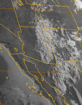
Friday, June 24, 2016
PW Up Over 30 mm
Another batch of cloudiness moving by this morning from Mexico (visible image above is from 6:30 am MST). However, it is not nearly as extensive today as it was yesterday. A couple of ALERT sites to the south actually had 0.04" from the light showers that were around much of day. High at airport yesterday was down 11 F from that on Wednesday. Most places around the metro had at least a Trace of rain.
This morning's sounding plot for TWC (below from SPC) indicates PW up to 1.41 inches (~36 mm), which is a nice increase and it's definitely humid out this morning. The sounding actually has some CAPE for low elevations, but the SPC algorithm is an over-estimate and my guess is that afternoon CAPE might be in 300 to 500 J/kg range. There is mixed flow at steering levels and winds at anvil level are unfavorable, since they would bring anvils out ahead of storms that develop to the south of metro area. So, things are improving but clearly have a ways to for conditions to be really favorable for desert storms.
The 06 UTC WRF forecasts from Atmo are a bit different with the GFS version above) having more thunderstorm activity off to our south and east at 4:00 pm. The NAM version (below, also at 4:00 pm) forecasts a couple of storms in eastern Pima County but not as much activity to south and east. So, another day to watch how the real world actually evolves.
Subscribe to:
Post Comments (Atom)


No comments:
Post a Comment