
Have been a bit distracted by TSs Bill (GoM) and Carlos (Ern Pacific) and didn't pay much attention to thunderstorm possibilities to our east. However, the CG flash density plot above (from Weather.Graphics/Vaisala for 24-hours ending 7:00 am MST this morning) indicates storm activity along the Rim Country and also the New Mexico border yesterday afternoon. There was a storm visible from here off to the distant east-northeast around 2:00 pm.

I have just looked at the WRF forecasts from the 06 UTC runs at Atmo and they are quite interesting. Both the NAM and GFS variants forecast thunderstorms in southeast Arizona this afternoon. The two forecasts of composite radar echoes here are both valid at 5:00 pm MST this afternoon (WRF-NAM above and WRF-GFS below). Both forecasts indicate strong thunderstorms over in Cochise County, but the NAM version also forecasts storms in Pinal and eastern Pima Counties (note that the current NWS forecast for the airport grid point has a 10% chance of measurable rain there today)..


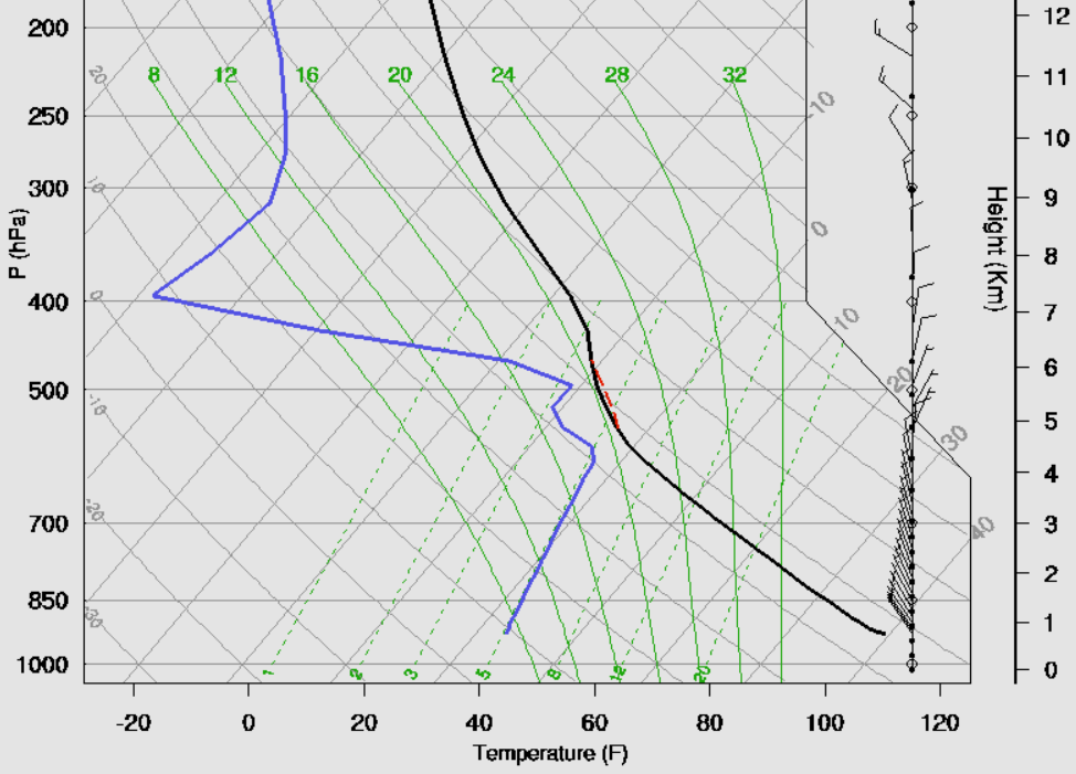
Here are the forecast soundings for TWC valid at 5:00 pm MST this afternoon. The WRF-NAM (above) forecasts a bit more moisture sneaking in from east and slightly cooler middle-level temperatures - subtle but important differences that yield CAPE in one sounding but not much in other. The forecast boundary layer (BL) is VERY deep, reaching almost to 500 mb (i.e., a troposphere that is half BL). Soundings as per above from the NAM version are notorious for strong to severe winds, blowing dust, and dry lightning - so there are weather concerns today.


Indeed, by 7:00 pm MST both variants of the WRF model forecast a strong mesohigh over Cochise County (where both models forecast some rainfall with the thunderstorms). The forecasts indicate severe winds along some portions of the outflow that is pushing westward across Santa Cruz, Pima, and Pinal Counties. At top above is forecast of 10-m winds from WRF-NAM and just above is same forecast from WRF-GFS. So, these model forecasts indicate significant thunderstorms, possible severe wind gusts, dust, and more dry lightning this afternoon and evening.
I will take a look at the morning observations in the next post.
No comments:
Post a Comment