
Full moon setting behind buildups to west this early morning. The 13 UTC IR image below shows dissipating MCS centered on Yuma.


The morning TWC sounding plot (above) shows much increased PW - up from 0.81 inches at 00 UTC last evening to 1.46 inches this morning. This increase was due to numerous outflows impacting Arizona during the afternoon and especially the early morning hours. These were working in concert with the local, diurnal circulations south of the heat low and in northwestern Sonora.
Below is forecast TWC sounding valid at 1 pm MST this afternoon - considerable CAPE that needs a bit of an outflow kick to produce low elevation storms. With cloud base holding around 600 mb, there's potential for more strong outflows.
An aside - it appears that today will be first day of the summer monsoon with an average dewpoint above above 54 F - as per the old NWS definition of when the monsoon starts locally (today would be the first day, if the next two days stay at or above 54 F). At least there was a bit of meteorology in that definition, as opposed to the current hand-wave that there's a "monsoon season" that begins June 15th. In fact,the season approach actually implies that there are separate "monsoons" occurring during the season, similar to the NHC tropical storm seasons for the basins.

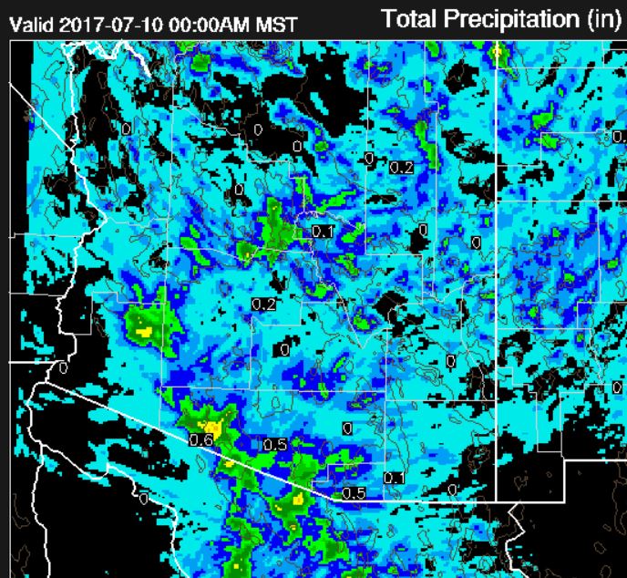
The 06 UTC WRF-GFS forecast for precipitation through midnight keeps significant activity mostly to south and west again today - but the soundings look better than that for low elevations - so it will be the main thing to watch this afternoon. The wind forecast for 10 m winds (below) is valid at 4:00 pm this afternoon and indicates a very strong outflow across the metro area by then.
Finally, Hurricane Eugene (bottom) is forecast to strengthen and perhaps stay close enough to southern Baja to increase the push of deep moisture into Arizona at mid-week.


No comments:
Post a Comment