Wednesday, January 31, 2024

Rain Likely By End Of Week


Venus rising at 6:05 am MST this morning, with a helicopter zipping by in foreground.

Forecast 500 mb chart (above - from 06 UTC GFS) shows negatively tilted trough crossing Arizona at 12 UTC on Friday, February second. Graphic below shows 09 UTC WRF-HRRR precipitation forecast through 5:00 am on Friday. Down at bottom is current morning forecast from the NWS Forecast Office.


Wednesday, January 24, 2024

Three Day Rain Event


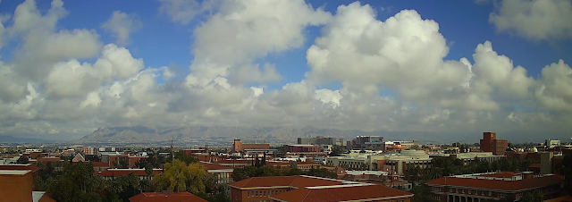
Morning view of low cumulus plus bright blue skies, looking toward the Catalinas at 11:00 am MST today.


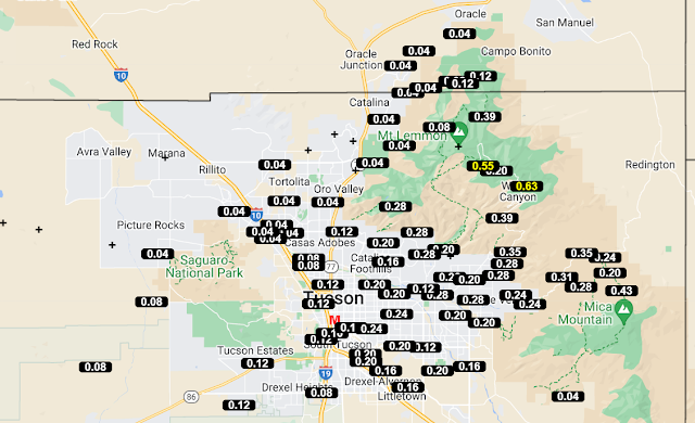
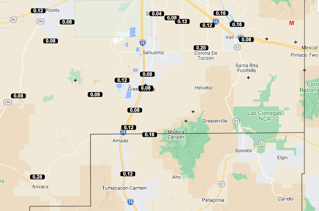
The event has ended and rainfall totals across the ALERT Network (above and below - for period ending at 11:00 am) show almost all sites had over an inch (note a couple of low, bad observations).
 Here at house we had a total of 1.67". This was largest single event here in over a year.

Tuesday, January 23, 2024

Overnight Rain Continued


View toward the Catalinas at 7:15 am MST this morning.

Plot of detected CG flashes through 1433 UTC (above - from Atmo and Vaisala) shows that all thunderstorm activity has, so far, remained far south and west of Tucson area.

Rain amounts for the event (ALERT above and below through7:30 am) show numerous sites with over an inch. Here at the house there is currently 1.42" in the gauge.


Plumes from the 06 GEFS runs (above and below) indicate heavy rains continuing later today. The temperature plumes show a distinct warm-up by early next week.

Monday, January 22, 2024

Event Update


Morning colors looking east toward the Rincons at 7:30 am MST today. Rain has ended for now across the metro area.

Event amounts, so far from the ALERT network (above and below). Quite a few sites had over an inch - note the suspect low amount near Green Valley. Here at the house there is currently 0.78" in the gauge.


Models continue to forecast additional significant rains into Wednesday morning. Forecast above is from the 12 TC WRF-RR and is valid through noon on the 24rth. Note the very heavy amounts forecast in parts of eastern Pima County. Current forecast from the NWS for the airport is shown below.

Sunday, January 21, 2024

Widespread Rain This Morning


View toward the Catalinas at 10:20 am MST this morning.

ALERT observations as per 11:00 am this morning showing widespread, mostly light rainfall since midnight last night. Here at the house there is currently 0.22" in the gauge.


The 06 TC plumes for QPF at the airport (above) continue to indicate a very significant event continuing through Tuesday. Plumes for PW (below) show a marked dry-out after Tuesday.

Saturday, January 20, 2024

Significant Precip Event Looms


Heavy clouds overhead at 10:00 am MST this morning.

The o6 UTC plumes for QPF at the airport (above) forecast a significant event beginning late tonight or tomorrow morning. 

The 00 UTC WRF-GFS (below) forecasts widespread, heavy precipitation across southeastern Arizona through 6:00 pm on January 24th.

Current NWS forecast for the airport is shown at bottom - very high POPs through next Tuesday.


Wednesday, January 10, 2024

Chance For Rain Tomorrow


Morning sun at 7:45 am MST this morning, highlighting Flattop and Finger Rock.

NOTE - Thanks for the comment alerting me that "Flattop" is actually Table Mountain.

Forecasts bring abrupt changes for tomorrow, as a strong, 500 mb short wave passes through Arizona - above shows 12 UTC GFS forecast for 500 mb at 11:00 am tomorrow.

Current morning forecast from NWS Forecast Office (above) for the airport calls for 80% POPs for rain tomorrow, along with an advisory for strong winds.

The GEFS plumes (from 00 UTC last evening - above) for QPF at airport all indicate rain, with average amounts around a tenth of an inch tomorrow. However, the morning WRF forecasts keep the precipitation well to our north - below shows 12Z WRF-RR precipitation totals through midnight tomorrow. 


The  GEFS plumes for winds (above) at the airport indicates steady speeds around 25 mph. Current NWS forecast calls for gusts as high as 45 mph at airport tomorrow. The WR-RR run (below) indicates steady speeds at airport of 29 mph at 11:00 am. Models agree on the strong winds but differ on precipitation locations - so an interesting day on tap tomorrow.

Tuesday, January 09, 2024

Brief Update


Wasn't able to post yesterday - here is a quick update.

Sunday's precipitation was snow up in Summerhaven, where visitors were jammed in traffic as they attempted to leave the mountain.

Temperatures here at house have been very cold, with lows of 22 and 21 F yesterday morning and this morning - coldest mornings of the winter.


Sunday's precipitation was light, but widespread. Here at the house I measured only 0.04". Four days already this month with measurable rain, but all amounts have been very light, totaling only 0.09".

Friday, January 05, 2024

Quick Look Ahead


View toward the Rincons at 6:40 am this morning.


Morning forecast from the NWS Forecast Office (above) for the airport continues the morning freeze warning through tomorrow. Sunday forecast indicates chance of showers, with perhaps some snow showers mixed in before the event ends.


Forecasts from the 00 UTC run of the WRF-GFS indicate a widespread precipitation event (above) through midnight Sunday night. The snow forecast (below) keeps the snow mainly at higher elevations  of eastern Pima County. It will be interesting to watch how things actually evolve on Sunday.

Thursday, January 04, 2024

Light Showers Early AM


Light snow occurred during the early morning hours at higher elevations - view of Summerhaven at 7:00 am MST this morning.


Early morning rain showers left mostly light amounts over portions of the ALERT Network (above and below for 24-hours ending at 7:00 am). Here at house we had 0.02"; DM had 0.05"; Atmo 0.03"; and the airport reported 0.02".

Current NWS morning forecast (below) indicates freeze warnings for tonight and tomorrow night, and then a chance of rain and perhaps snow showers by Sunday evening.

Wednesday, January 03, 2024

Chance For Showers Tonight


Clear skies over the Catalinas at 7:40 am MST this morning.

The morning 500 mb analysis (from SPC - above) shows a strong trough over California. This feature is forecast to move southeastward, crossing Arizona tonight. Graphic below shows the GFS forecast for 500 mb valid at 12 UTC tomorrow morning.


The WRF runs at Atmo are indicating a widespread coverage of light precipitation across all of southern Arizona with the passage of this trough. The 12 UTC WRF-RR forecast for precipitation through 5:00 am tomorrow morning is shown above. The current morning forecast from the NWS Forecast Office is shown below. Note that models are forecasting a stronger, colder system over Arizona on the coming weekend that will bring snow to fairly low elevations.