Wednesday, June 30, 2021

Increased Activity Today


View above of Catalinas is from a bit before 9:00 am MST - note that cumulus are already building over the mountains. View below is of heavy cumulus over mountains at about a quarter to seven pm last evening. Plot of rainfall (second below - from MesoWest) shows some light amounts at several sites in the east-central metro area for the 24 hours ending at 5:00 am this morning.


This morning's sounding (above) from TWC shows increased PW and CAPE, with a much lower lifted condensation level that is actually a bit below 700 mb. The steering winds are light, with variable directions, so slow moving storms with potential for heavy, local rain amounts.

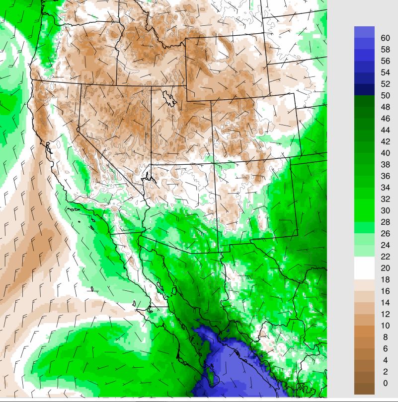
Forecast of radar echoes above is from 06 UTC WRF-GFS run at Atmo and indicates early, heavy storms in metro area shortly after noon. Precipitation amounts through 11:00 pm tonight (below) indicates widespread rainfall across much of Pima County.

Finally, the 06 UTC GFS forecast for total precipitation through 12 UTC on Monday the 6th of July indicates a wet Holiday weekend.

Tuesday, June 29, 2021

Another Windy Morning


Clouds over the Catalinas at sunrise this morning, as viewed from campus.

Thunderstorms yesterday mostly avoided Pima, Santa Cruz, and Cochise Counties, as per plot of detected CG flashes (above - from Vaisal and Atmo) for 24 hours ending at 11:30 MST last night. However, there was a severe thunderstorm that produced wind damage west-northwest of Safford. There were some light showers across parts of the metro area during the night - two sites had measurable, but less than 0.05", amounts, and the airport and DM reported Traces.

Surface plot above from a bit before 6:00 am shows warm temperatures and some windy spots across Arizona. Winds were gusting 20 to 30 mph here at sunrise, and around 2:30 am Marana report gusts to 43 mph and the airport reported 35 mph. Visible satellite image from 7:20 am (below) shows heavy cloud cover over New Mexico, while eastern two thirds of Arizona is mostly clear.


The NHC was still calling Enrique a Tropical Storm this morning, but satellite images show what appears to be a remnant low with little or no deep convection. The remnants will still help to keep low-level moisture moving into Arizona, but with highest PW amounts remaining out west in the lower Colorado River Basin.

Morning sounding above from TWC shows multiple, residual boundary layers, with the layer below 850 mb having the most cooling and moistening since yesterday. The surface parcel has has the most CAPE, with the mixed layer having less. However, DCAPE is very large, indicating significant potential for strong outflow winds. The 06 UTC WRF-GFS forecast sounding for TWC at 4:30 pm this afternoon (below) shows a single mixed layer, with surface CAPE fairly large, but mixed CAPE quite a bit smaller. The model does forecast light showers moving south across the metro area this evening.


Monday, June 28, 2021

Gusty Winds This Morning/Increasing Chance Showers This Week

Strange yellow/orange skies at sunrise this morning (above and at bottom). Strong easterly winds have brought in dust and perhaps some smoke aloft from the east.Winds have gusted just over 40 mph at both the airport and Pioneer Airfield early this morning, with gusts over 30 mph fairly common across southeast Arizona.

Hurricane Enrique has not intensified and remains a fairly unorganized Cat 1 storm - visible image above from 14 UTC. The current forecast from NHC (below) has shifted eastward and takes the weakening storm/depression eventually across southern Baja during the week. The more easterly track means the pressure gradient will likely point down the GoC and makes timing of moisture surges into southern Arizona more uncertain.

The plot of detected CG flashes through 8:00 pm MST last evening (second below) shows widespread thunderstorm activity from northeast of Enrique into southwestern New Mexico.


The precipitation forecast through 6:00 am (above - from the 06 UTC run of the WRF-GFS at Atmo) indicates little precipitation across all of Pima County for today and tonight. The model also forecasts (below) a return of moisture during the week, with local values around 35 mm by 06 UTC on Friday the first day of July. Current forecasts for measurable rain at the airport begin at 30 % for today and increase considerably through the week. Looks like the start of the summer thunderstorm season (aka monsoon) is imminent.


Saturday, June 26, 2021

Hurricane Enrique


Skies currently very clear - view south from Kitt peak above at a bit before 7:30 am MST this morning. Model forecasts increasing PW next week, and the current morning forecast from TUS NWS indicates 70 to 80 percent POPS for measurable rain at the airport for every forecast period Tuesday through Friday, July 2nd. I can't remember such high POPs for this long of a period, but certainly will be rooting for storms and some significant rainfall.


A wild card in the the weather situation is Pacific storm Enrique. The NHC declared Enrique to be a Tropical Storm Friday morning and upgraded it to a hurricane early this morning. Current location shown in satellite image above and forecast track below. Current intensity is Cat. 1, but storm is expected to become a Cat. 3 storm as it moves toward the southern end of Baja. The track of the storm should produce a strong Gulf surge that would reach into southwestern Arizona sometime Thursday morning.


The MIMIC TPW at 13 UTC this morning (above) shows Enrique's swirl of very high values, but with quite dry air over Arizona and the northern half of the GoC. The current model forecasts indicate a quick return of moist air into southern Arizona (below is PW forecast from the 06 UTC WRF-GFS run valid at 1:00 am on the 29th). Note that the increase in southeast Arizona appears to be coming in from the east - given the down-slope trajectories, there could be problems getting decent CAPE over our area. Things will be further complicated by falling pressures at the southern end of the GoC

Below is forecast skew-T for TWC from same WRF run valid at  1:00 am on the 29th. Note the very deep residual boundary layer, with limited CAPE and very high cloud bases. The moisture and CAPE does increase substantially by Tuesday afternoon. Should be an interesting weather week as we head for July.


Friday, June 25, 2021

Bear Crossing Airport

Black bear crossing taxi way at McCall, Idaho, airport. Apparently heading to check out a Lear (?) jet on the tarmac.. 

Checked a bit later (below) and he was long gone.

Both images from Jack Hales' webcam wall - link to right.


Enrique/Dry Weekend Here


We had a golden sunrise this morning in this part of the city. Image down at bottom shows a really large crowd watching Old Faithful do its thing this morning.


At 4:00 am (PDT) this morning the NHC declared that the disturbance off of southern Mexico had strengthened to become TS Enrique - IR satellite image above.  The forecast for Enrique (below) indicates the storm will strengthen as it moves slowly northwestward toward southern Baja - remains to be seen whether the storm might eventually impact the Southwest.


The morning sounding for TWC (above) shows dry west winds above about 650 mb and no BL CAPE. The 500 mb analysis (from SPC below) shows a chopped-up pattern across sourthen half of US that is dominated by a large ridge from northern Mexico to the East Coast, but with weak lows over Florida and California/Nevada border.

The 06 UTC GEFS QPF plumes (second below) for the airport indicate a fairly wet week beginning Monday. 


Thursday, June 24, 2021

Storms In Metro/Severe In Nebraska

There were light showers and thunderstorms across the metro area yesterday afternoon - above view of Catalinas at 4:00 pm MST and below shows view to east from Sahuarita at 3:45 pm.


Plot above shows CG flashes detected yesterday afternoon and evening, with considerable CG activity across southern half of Arizona.

Rain reports from yesterday for 24-hours ending at 7:00 am this morning: above from the ALERT network and below from MesoWest. Heaviest reports were from sites west of Green Valley and Tubac.

Here at house we had thunder (reported to me by neighbor John Ferner), but only a light shower that left 0.02" in the gauge - not even enough to wet the open ground.


Map from SPC (above) shows locations of severe storm reports yesterday (through midnight MST). There were isolated reports around the West - report in California was of a semi blown over on I-10. 

However, a derecho in northeastern Nebraska produced numerous reports of strong winds and wind damage. The three graphics below show: IR satellite image at 0200 UTC today (note that horse-shoe shaped IR signatures are almost always associated with severe thunderstorms); IR at 0635 UTC middle; and radar base scan from Omaha NWS at 0635 UTC at bottom. Strongest wind gust of 84 mph was measured by an automated surface station at Albion (southwest of Norfolk).


Wednesday, June 23, 2021

Interesting Situation Later Today


Hazy skies at 7:00 am MST this morning, with some high-based cumulus overhead. There were some sprinkles around early last night, and the NWS and DM both reported a Trace of rain - couldn't tell if there had been a sprinkle here.

The NWS weather story this morning (above) calls for scattered thunderstorms today and forecast below indicates 50% of measurable rain at airport today, decreasing tonight.


Visible satellite image from 7:21 am (above) shows significant cloud cover over northwestern two thirds of Arizona, extending into California and Nevada. The phoenix radar (below) at the same time indicates thunderstorm activity extending southwest into far western Pima County. Plot of detected CG flashes (second below) shows about the same thing for last couple of hours (white to pink shades).


The 500 mb anticyclone has shifted eastward and is centered near the Texas - New Mexico border southwest of Amarillo.


The interesting aspect of today's situation is the WRF forecasts, compared to the NWS forecast. The forecast TWC sounding above is valid at 6:00 pm this evening - sounding looks quite favorable for evening storms. However, that run's forecast of total rainfall through 6:00 am on Friday leaves most of the metro area high and dry. So, dueling forecasts - given how bone-dry it is here at house, I'll be hoping for storms later today.