Wednesday, March 30, 2022

Nice Rain To End March


Showers yesterday occurred from morning into early afternoon and produced amounts that were the highest of the new year. View above is of the Catalinas from campus at 7:13 am MST. Bottom view (7:00 am) shows snow still falling at top of Mt. Lemmon. 


ALERT measurements (above and below) shows that amounts were mostly less than half an inch. The airport only recorded 0.03"; DM 0.02"; and Atmo 0.11" - all within a zone of minimum amounts across southern parts of the metro area. Here at house I measured 0.30", the most since late last year. The 1.61" amount at west end of Catalinas appears highly suspect - I think this site has had overly high amounts in the past also.


Tuesday, March 29, 2022

Showers Likely Today


Heavy clouds overhead this morning at 6:47 am MST, but with a bit of blue and sunshine over western Catalinas.

Yesterday there were widespread sprinkles, with most sites across metro reporting a Trace - which is what we had here with a very light shower around 7:30 pm.

Plot of detected CG flashes for last 24 hours (below from Atmo and Vaisala) indicates early morning thunderstorm activity to our north and northwest (purples).


The morning sounding plot for TWC/TUS (above) shows continued strong winds aloft and a bit of CAPE below 500 mb. Some wind gusts yesterday afternoon: Marana 41 mph;Tucson 38 mph; DM 41 mph; Nogales 44 mph; and Pioneer Airfield 47 mph.

The 06 UTC GFS forecast for 500 mb, below - valid at 5:00 pm this afternoon - indicates that the trough currently over California, will move to the Arizona/New Mexico border during the day.


Above is morning rainfall graphic for today from the NWS Forecast office - POPs for airport are 100 % with amounts of a quarter to half an inch expected. The 06 UTC WRF-GFS forecast for precipitation  (below, valid through 6:00 pm this evening) indicates not quite as much at the airport, but with higher amounts over much of eastern Pima County.

Monday, March 28, 2022

March Ending With Showery Weather

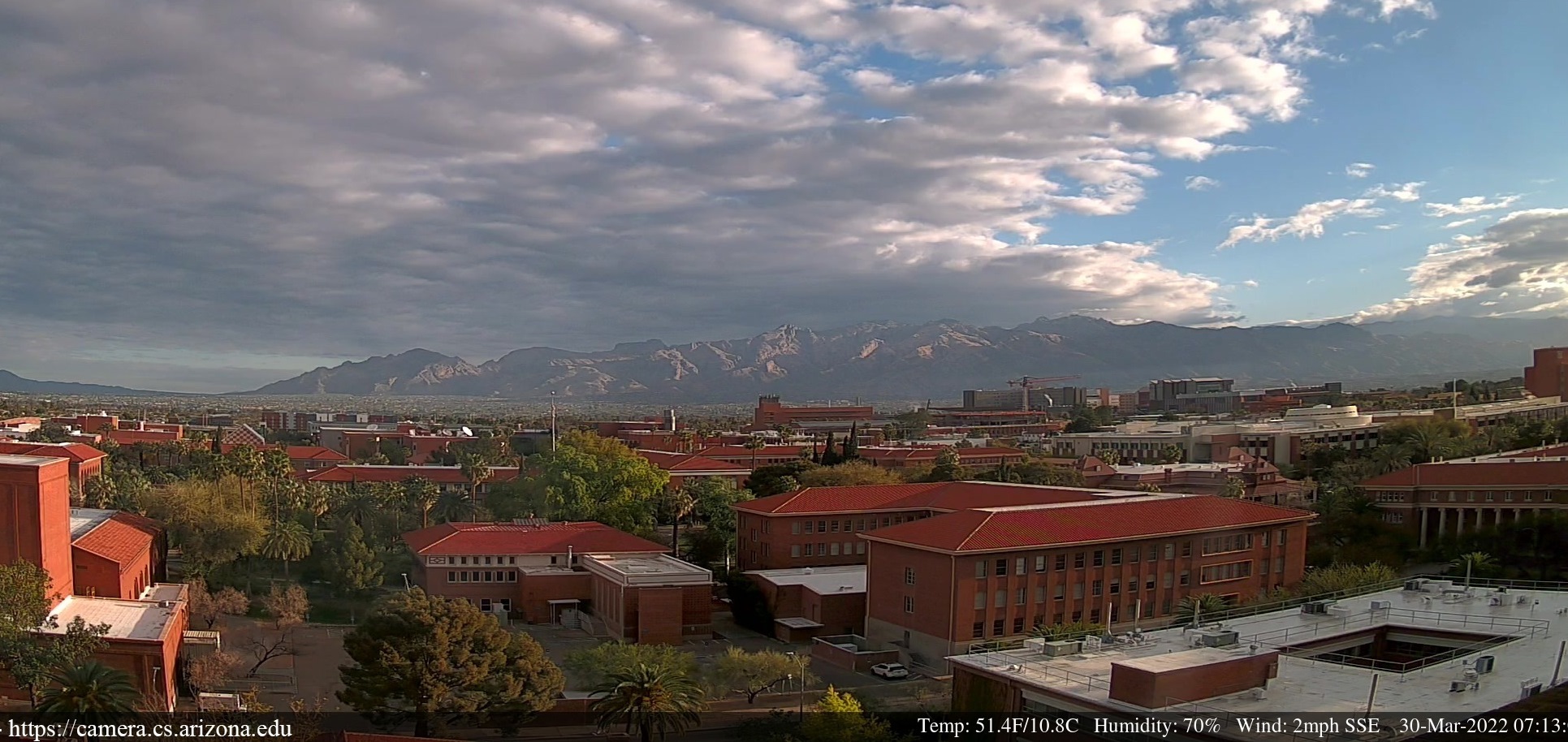
Some nice color over Catalinas a bit before sunrise this morning.


The NWS has issued a Red Flag Warning for critical fire danger today, as per area shown above, due to strong winds and low relative humidity. The 06Z run of the WRF-GFS at Atmo forecasts steady winds in 20 to 25 kt range both this afternoon and tomorrow. Forecast below is for winds at noon tomorrow, with strongest speeds over New Mexico and northern Mexico.


A strong 500 mb system is west of California this morning, and the 06 UTC run of the GFS model forecasts it to be over Arizona by 1800 UTC tomorrow (above). The GEFS plumes (below) continue to forecast rainfall at the airport during the day tomorrow - as they have for past 4 or 5 days. Amounts have been fairly consistent too, with averages of 0.2 to 0.3" at the airport.

Above is the 12 UTC sounding plot for TWC, showing moist conditions above 500 mb and strong winds aloft, from just above the surface. Forecast sounding below (from same WRF run) is valid at 11:30 am MST tomorrow morning. Forecast indicates CAPE after frontal passage, so there may be a chance for some thunder, since CAPE layer extends well above the -10 C level. 

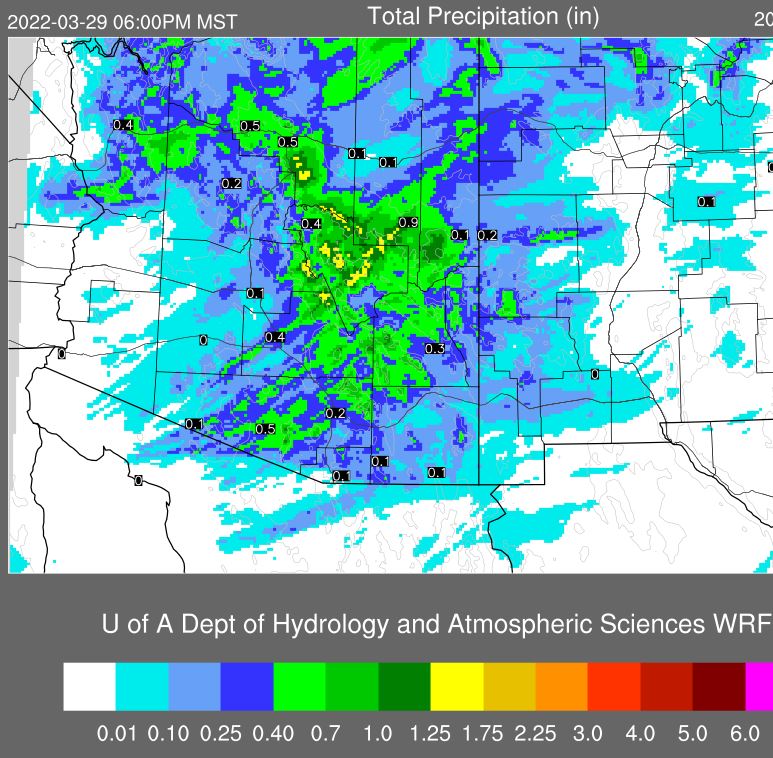
The WRF forecast for precipitation through midnight tomorrow is shown in second graphic below. It indicates 0.20" at airport, but with higher amounts over much of Pima County.

March definitely not going out like a lamb this year.


Saturday, March 26, 2022

Brief Update

Pre-sunrise colors this morning showing yellows to pinks - above from campus and bottom from Sahaurita.

Models continue to forecast a precipitation event early next week. Morning forecast from NWS (above) for Monday night through Tuesday night this coming week. Note the 90 % POPs for Tuesday, which is three days away. The QPF outlook (below, also from NWS) indicates amounts for the metro area of a quarter to half an inch for the event. If the forecast verifies, this would be largest event of 2022 so far.

Forecast QPF from 06 UTC WRF-GFS at Atmo (second below) for period through midnight on the 29th indicates 0.10" at airport, with heavier amounts to the north of the metro area.


Friday, March 25, 2022

Showers Before End Of March?


Pre-sunrise color this morning, looking east along I-10 from Wilcox.
Plumes for QPF at the airport (above) from the 06 UTC GEFS this morning - all of the ensemble members forecast rainfall at airport late Monday night into Tuesday.

 Current forecast from NWS indicates 60% POPs for Monday night and 80% for Tuesday. 

Forecast below is from the 06 UTC WRF-GFS run at Atmo, and is for precipitation through 6:00 pm MST Tuesday afternoon - the forecast is similar to the GEFS, with 0.20" forecast at the airport. Note the strong north-south gradient, with around an inch and half indicated for eastern Pinal County.


The GEFS plumes for temperature (above) indicate a dramatic cool down for Tuesday, but with another quick rebound. The WRF forecast (below) indicates 91 F at airport tomorrow, with all of southwest Arizona quite hot for this time of year.


 The plumes for wind indicate a blustery/windy afternoon here on Monday, and WRF forecast below (valid at 3:30 pm om Monday) indicates the same.

Perhaps I'll get a bit more rain in the gauge here before the month ends - precipitation here for month, so far, is only 0.03" (NOT 0.04" as I reported earlier).


Monday, March 21, 2022

Bit Of Rain Here


Heavy clouds over central and eastern Catalinas at 3:00 pm MST yesterday afternoon  We had a light shower here around 4:00 pm, but it only left 0.04" in the gauge. Other spots around area did much better (e.g., airport had 0.17" along with thunder, and two ALERT sites had over half an inch).

Image at bottom shows snow cover at the Mt. Lemmon General Store this morning.


The TWC sounding at 00 UTC yesterday (above) was quite similar to that forecast by the WRF - see previous post. There was enough CAPE to support thunderstorms, as per plot of CG flashes (below) for 24-hours ending at midnight last night (from Atmo and Vaisala). Note that much of the metro area was in in a donut hole.


ALERT observations for 24-hours ending at 8:00 am this morning. Most sites in the central and north metro had a Trace to 0.03" - i.e., not enough to make the ALERT cutoff.

Main question now is whether this event will be the only one for the month? The current model forecasts indicate that this may be the case.


Sunday, March 20, 2022

First March Rain?


Nice pre-sunrise color this morning with middle and high clouds overhead - top from campus and bottom from Sahuarita. Today is the first day of astronomical spring, and perhaps it will bring us the first rain of meteorological spring?

Plumes from the 06 UTC GEFS members (above QPF at airport and below temperature) indicate a high chance for light rain today and tonight. The temperatures are forecast to be cool today and tomorrow, and then to warm dramatically during the week.


The morning sounding from TWC/TUS is very dry, but the 13 UTC TPW analysis (above) indicates values over half an inch out in southwest Arizona. An approaching 500 mb trough will help bring the moisture our way today.

The 5:30 pm MST sounding forecast from the 06 WRF-HRRR (below) shows some CAPE below 500 mb by late afternoon. Looks marginal for thunderstorms, but certainly supportive of low-top showers. Second below shows precipitation forecast by same model run through noon tomorrow. 

Should be an interesting afternoon and evening.


Thursday, March 17, 2022

St. Patrick's Day


Pre-sunrise view this morning from Sahaurita. Today is St. Patrick's Day and the greens are showing in places like Chicago and Sydney Australia (bottom).


Re yesterday's post - it was indeed "windy" here yesterday as per TUS observations above, and the NWS definitions table shown in previous post.

The GEFS runs from 06 UTC today indicate a substantial cool-down coming for Sunday and Monday (above), as well as another windy period (below). Most models are also forecasting a slight chance for light showers Sunday and Sunday night. The brief period of unsettled weather is followed quickly by a return to mild weather. 

Still no rain in March here at the house. My records (beginning in 1999) indicate that there has not been a March here with no measurable rain.